NBAcentel
Member
GSP 
Beautiful!


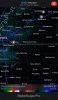
Dk why it's so blurry but there's a 30-60% chance across most of nc and scThese really aren't bad probabilities for accumulating snow (0.1 inch.)
Sent from my Pixel 3 using Tapatalk
These really aren't bad probabilities for accumulating snow (0.1 inch.)
Sent from my Pixel 3 using Tapatalk
Nice dry hole over Oconee and Anderson...gotta love itDk why it's so blurry but there's a 30-60% chance across most of nc and sc
Sent from my Pixel 3 using Tapatalk
Yeah for sure but those are still decent probabilities for everyone. I realize it's only 0.1 but I think that would definitely be a win.Look's a little bit off... A 20% drop-off from CLT to Union County? While Chester is at 39%? Normally the area's around the Southern Piedmont do better than other areas during these setups. Oh well, just thankful I don't live in Union anymore.
Yep. I was at 56 at 2:15 and now at 39. Wow.Cold front has passed through and the temperature is plummeting fast. Went down 5 degrees in the past 10 minutes.
Cold front has passed through and the temperature is plummeting fast. Went down 5 degrees in the past 10 minutes.
These really aren't bad probabilities for accumulating snow (0.1 inch.)
Sent from my Pixel 3 using Tapatalk
.jpeg")
Radar Returns are increasing around there. Flizzard warning activate!Corinth, MS reporting snow at 2:35