Could you post the Ptype for Columbia/Augusta Areas!!Pretty much every model now has that band reformation after it breaks up, just now looking at the Euro. It'll just be a matter of when it can and where it has the most impact south of NC.
-
Hello, please take a minute to check out our awesome content, contributed by the wonderful members of our community. We hope you'll add your own thoughts and opinions by making a free account!
You are using an out of date browser. It may not display this or other websites correctly.
You should upgrade or use an alternative browser.
You should upgrade or use an alternative browser.
Wintry More SE Snow ? (1/16-1/18)
- Thread starter GeorgiaGirl
- Start date
B
Brick Tamland
Guest
GeorgiaGirl
Member
Could you post the Ptype for Columbia/Augusta Areas!!
It's good even in South Carolina I think due to rates. Rain first but some time with good snow.
SnowMan
Member
Just subtract 6 hours from the Z time - 20Z = 14 central or 2 PM.Newbie question ...sorry...what is that time frame?
ForsythSnow
Moderator
48 here with darkening clouds to the west. More clouds since 11.
WarEagle22
Member
EURO looks to have the band reforming a little later on.
It could be semantics, but there are times in snow storms where every mile counts. That sliver of section B over into Richland County (South Carolina) is practically the area where I reside.
GeorgiaGirl
Member
Hmmm, that map looks familiar.
") I may have gotten my wish of a complete return to what the Euro was showing the day before this thread was started.
I may have gotten my wish of a complete return to what the Euro was showing the day before this thread was started.Wow EURO shafts SE TN
Snowflowxxl
Member
Clouds moving into ATL, 49 degrees
DadOfJax
Member
Yep...exactly what I was afraid of. Doesn't mean its going o happen that way, but I don't like the looks of that.EURO looks to have the band reforming a little later on.
Whats with southeast TN getting shafted but the HRRR having over 2-3" here. The consensus is still large. Not to mention the radar in Huntsville being down to
WarEagle22
Member
Wow EURO shafts SE TN
Ya and pretty much Central Bama too. I dunno if I buy that though. Short term models show different.
Phil Connors
Member
Global models are pretty useless at this juncture.
The Euro is farther south yet prints off a large chunk of 0.2-0.3" of QPF. If that axis is farther north, NWS BMX nails this forecast of 2-4".
Storm5
Member
Man some nice returns North north of Jackson Mississippi shooting NE
Sent from my SM-J320VPP using Tapatalk
Sent from my SM-J320VPP using Tapatalk
ForsythSnow
Moderator
Agreed. It's too close to be using about 3 to 6 frames. They also can't analyze minor changes until their next run unlike the HRRR.Global models are pretty useless at this juncture.
ARCC, hate to ask a IMBY post, but what are your thoughts up my way? I seem to be right on the line of where the heavier band may set up (Extreme SW Jefferson county). I feel like you're sitting pretty, I am just hoping I am far enough south to get into the good stuff. I am a bit nervous.The Euro is farther south yet prints off a large chunk of 0.2-0.3" of QPF. If that axis is farther north, NWS BMX nails this forecast of 2-4".
cd2play
Member
Ended up with about 2.5 inches of powdery snow in Nashville, aka "Smashville"
LovingGulfLows
Member
- Joined
- Jan 5, 2017
- Messages
- 1,499
- Reaction score
- 4,100
Latest HRRR looks fantastic for my area just east of Atlanta. Hour 14-16 redevelops the entire band and puts another round of moderate to heavy snow over Atlanta and east/south.
NoSnowJoe
Member
Kirk Mellish tweet fro about 45 minutes ago
New data from morning weather balloon release starting to come in, most interesting trends: driest NE suburbs in mtn shadow heavier south of #ATLweather and middle #gawx still wide range of amounts from each model smh, either way cold wave won't be denied. More later.
New data from morning weather balloon release starting to come in, most interesting trends: driest NE suburbs in mtn shadow heavier south of #ATLweather and middle #gawx still wide range of amounts from each model smh, either way cold wave won't be denied. More later.
ARCC, hate to ask a IMBY post, but what are your thoughts up my way? I seem to be right on the line of where the heavier band may set up (Extreme SW Jefferson county). I feel like you're sitting pretty, I am just hoping I am far enough south to get into the good stuff. I am a bit nervous.
I don't know, these things are so fickle. I definitely think you are sitting better if you are close to the same areas that December 8th hit, but it may be even farther SE.
Radar is really showing signs of that second band trying to form.
Kylo
Member
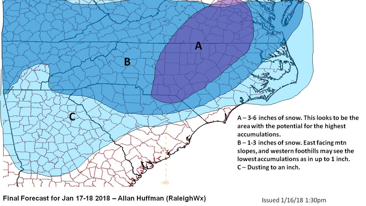
I don't like updating my map, but too much evidence not to bump up totals slightly in the highest zone. I also adjusted my colors slightly haha.
View attachment 3128
Are you surprised that RAH stayed with 2 inches across the triangle for the noon update? I guess if 4 inches happens they would rather be low then higher maybe.
ForsythSnow
Moderator
Can someone explain to me what even is with them mentioning the mountain shadow? I keep seeing it, but it makes no sense. The moisture is from the SW, not the NW. Only low level flows are.Kirk Mellish tweet fro about 45 minutes ago
New data from morning weather balloon release starting to come in, most interesting trends: driest NE suburbs in mtn shadow heavier south of #ATLweather and middle #gawx still wide range of amounts from each model smh, either way cold wave won't be denied. More later.
Yep, I am liking what I am seeing, but I'd like to see more. Would love the jet streak to shift north by about 100 miles.Latest HRRR looks fantastic for my area just east of Atlanta. Hour 14-16 redevelops the entire band and puts another round of moderate to heavy snow over Atlanta and east/south.
Attachments
atlantasweetie
Member
Update: 48 here as well.
Sent from my ONEPLUS A3000 using Tapatalk
Sent from my ONEPLUS A3000 using Tapatalk
Yep, I am liking what I am seeing, but I'd like to see more. Would love the jet streak to shift north by about 100 miles.
Where is the jet streak projected to align? I recall Simmons speaking of this earlier.
Yeah l am trying to hold myself together l think where l am is a very good placeI don't know, these things are so fickle. I definitely think you are sitting better if you are close to the same areas that December 8th hit, but it may be even farther SE.
Radar is really showing signs of that second band trying to form.
accu35
Member

ramsewr
Member
Wow at the returns in south eastern Texas along the Texas/Louisiana border. They must be getting slammed. So unusual for it to snow that far south. Crazy weather this year!
Benholio
Member
Can someone explain to me what even is with them mentioning the mountain shadow? I keep seeing it, but it makes no sense. The moisture is from the SW, not the NW. Only low level flows are.
There is a ~3 degree dewpoint difference in the wedge area compared to the surrounding areas. I don't know how big of a deal that is, but with limited QPF, we can't afford to lose too much saturating the column.

DadOfJax
Member
Unbelievable that places south of I20 are looking to score much better than north yet again. SMH!
Xtreme Weather
Member
I don't know, these things are so fickle. I definitely think you are sitting better if you are close to the same areas that December 8th hit, but it may be even farther SE.
Radar is really showing signs of that second band trying to form.
Someone may get lucky as storms begins to tilt at 500mb and slow down and if your under it I think may get another 2-3hrs of bonus precip
ForsythSnow
Moderator
The sooner those hit the Gulf and die out, the sooner we can fire hose the northern areas. Probably why N MS got screwed.Wow at the returns in south eastern Texas along the Texas/Louisiana border. They must be getting slammed. So unusual for it to snow that far south. Crazy weather this year!
mjscott30
Member
From WSFA: The precipitation is going to start a bit earlier, say around mid-afternoon but, temperatures should be well above freezing when that happens, meaning most or all of what falls will be rain for the Montgomery area. But, as cold air rushes in, the rain will transition over to a mixture of sleet and snow, our thoughts on the timing of the snow haven't changed much.
Storm5
Member
Thats the key once the tilt starts she will slow down . Get under the band as it pivots and boomSomeone may get lucky as storms begins to tilt at 500mb and slow down and if your under it I think may get another 2-3hrs of bonus precip
Sent from my SM-J320VPP using Tapatalk
weatherguy
Member
I got 1/8" in 30 min within the 15 dbz from 12pm to 12:30pm, so 1/4" per hour rates in the 15 dbz. Current total here in Franklin county AL: 7/16" of snow
B
Brick Tamland
Guest
4 inches is looking more and more like a safe bet for central NC.