• Hello, please take a minute to check out our awesome content, contributed by the wonderful members of our community. We hope you'll add your own thoughts and opinions by making a free account!

Wintry More SE Snow ? (1/16-1/18)

Again, we don't have temps, but I will be posting the higher resolution UKMET map when I retrieve it here in a few.

Again, expect Euro to increase moisture for some based on UKMET.
 
FWIW - the CMC surface temps are really messed up. At 18z on Wednesday in Wake County the CMC has already dropped 0.1", yet it's still 35/30 AND the 925mb temp is -2C in Wake County. At 12z it had the temps at 26F/20F. There is no way you go from that to 35F/30F with 0.1" QPF falling by 18z.

Agreed, the diurnal cycle might be too strong on the model and/or too much radiation may be penetrating thru the thick low-mid level clouds, unless we had an exceptionally strong low inland of the Carolinas that's not too feasible to see a substantial warm-up in surface temps like that...
 
Agreed, the diurnal cycle might be too strong on the model and/or too much radiation may be penetrating thru the thick low-mid level clouds, unless we had an exceptionally strong low inland of the Carolinas that's not too feasible to see a substantial warm-up in surface temps like that...
Is the main problem with our NWP that our data collection network isn't extensive enough?
 
NWS forecast for states..
Alabama is max 1.1 inches average .3 inch
more here:
Georgia 0.9 0.1
Tennessee 3.2 1.2
North_Carolina 2.7 0.5
Mississippi 1.6 0.7

found on weather bell so I didn't link it
 
Is the main problem with our NWP that our data collection network isn't extensive enough?

Tests had been run in the past of giving the Euro's initialization parameters to the GFS and it's forecast would sometimes outdo the Euro.
 
My UKMET source is slow; but here are the temps into the Carolinas as the precipitation is starting to fall in the Upsate:

TS_TS_PN_060_0000.gif
 
Is the main problem with our NWP that our data collection network isn't extensive enough?

That's definitely part of it and I think it would be beneficiary if we expanded our RAOB network (unfortunately this is very low on the government's list of priorities (if it's on there at all) as you can probably tell by their recent cuts to the NWS). Even if we could measure every point on earth at all points in time to initialize our models, it wouldn't entirely fix the problem because we're limited by the nature of NWP models themselves in that their internal physics, data assimilation schemes, and dynamical cores are far from perfect and we often lose some valuable information about particular phenomena (such as convection) at the expense of computational efficiency & producing output in a timely fashion w/ a coarser grid model...
 
Hey Eric, looking over 850 maps, that UKMET while warm down into parts of the Carolinas, might not be much rain. There is 0.30QPF falling in 6 hours or less in some of those zones that may argue to bring down the flakes faster and try to cool it down just enough. In fact, if we start to see a trend of moisture to get into the 0.30-0.50 range some miraculous way, some could really make out with bandits even with marginal temperatures.

In fact, that UKMET in theory, looks like some of the old ridiculous ensemble members of 4-6 inches of snowfall easily.
 
very similar for Alabama
26855899_1988314727862842_1319989317_n.png
 
Euro swings through as a nice snow band, then legit turns it right to rain for the Midlands of SC. ;) that problem is not going away, sorry guys.
 
Let's hope the short range models are right and not the Euro

Sent from my SM-J320VPP using Tapatalk
Yea no kidding . Just kinda shocked how the euro just dried it up. Oh well today by noon we will be in short range model range.
 
Whos up for the Nam, i know i am. Im on lunch break LOL.
 
00z EPS was lighter for some areas vs 12z EPS:

eps_snow_m_se_15.png
 
namconus_apcpn_us_25.png
The trend on the Nam has been better with precip and further south. I hope this trend keeps it up today.
 
SREF matches up nicely with the NAM for precip amounts around CAE 0.05 , yes, 5 - one hundredths. basically a couple flurries floating around.

20% chance of 0.05

Still not anything worth looking @ my SC Midlands friends.
 
How come some images aren’t showing up and others are? Just recently starting noticing this.


Sent from my iPhone using Tapatalk
 
  • Like
Reactions: Jon
FFC Morning AFD
Area Forecast Discussion
National Weather Service Peachtree City GA
419 AM EST Mon Jan 15 2018

.SHORT TERM /Today through Tuesday Night/...

Main focus is on the back portion of the fcst period (later Tuesday)
given the increasing potential for some light accumulating snow with
a fairly deep zone of moisture interacting with another strong cold
front and amplifying trough to the west. While thermal profiles and
partial thicknesses are in good consensus of mainly an all snow p-
type, the main question remains how much QPF and what snow to water
ratio would be progging expected snow amounts. WPC mean ratios look
to be close to 12 to 1, though will need to watch for any lift
potential in the dendritic growth zone that could locally enhance
amounts (which has some differences in the models). Still thinking
generally near 1 inch in the far north and now closer to a quarter
to half inch farther south including the Atlanta metro, and a tenth
of an inch as far south as Columbus to Macon to Warrenton. Onset
timing seems slightly earlier with the far NW as early as noon
Tuesday, then near Atlanta by the evening. Moisture and forcing
should shift east of the area by sunrise Wednesday, though sfc temps
will be bitterly cold with much of north GA in the teens. What is
able to accumulate will have a hard time melting Wednesday since we
struggle to get above freezing for the northern half of the CWA.
Given enhanced gradient winds behind the front, the resultant wind
chill values late Tuesday into Wed should range from the single
digits in north and west central GA to sub-zero in the far north.
All in all have opted to continue a Special Weather Statement for
this system since the amounts do not warrant Watch criteria and
timing/uncertainty in amount of precip is shy of warranting an
Advisory with this fcst package. This may be very well warranted
later today to cover updated expected snow totals and wind chills.
 
Nws just issued winter storm watch for Cherokee and etowah Alabama and that's to the east ?
 
Winter Storm Watch
URGENT - WINTER WEATHER MESSAGE
National Weather Service Birmingham AL
329 AM CST Mon Jan 15 2018

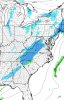
...SNOW MAY BRING SIGNIFICANT IMPACTS TO MUCH OF CENTRAL ALABAMA
TUESDAY MORNING THROUGH EARLY WEDNESDAY MORNING...

.An Arctic cold front will enter Northwest Alabama Tuesday morning
and move southeastward across Central Alabama Tuesday afternoon
into Tuesday night. This front should have enough moisture and
lift to generate a band of light to moderate snow, which could
potentially affect all of our forecast area. Currently the best
chance for accumulating snowfall appears to be along and north of
a line from Demopolis to Clanton to Wedowee. Though snowfall
amounts are expected to remain less than 2 inches, impacts to
travel could be significant due to temperatures falling into the
20s as the snow occurs.

ALZ011>015-017>036-152200-
/O.NEW.KBMX.WS.A.0001.180116T1200Z-180117T0900Z/
Marion-Lamar-Fayette-Winston-Walker-Blount-Etowah-Calhoun-
Cherokee-Cleburne-Pickens-Tuscaloosa-Jefferson-Shelby-St. Clair-
Talladega-Clay-Randolph-Sumter-Greene-Hale-Perry-Bibb-Chilton-
Coosa-
Including the cities of Hamilton, Sulligent, Vernon, Fayette,
Double Springs, Jasper, Oneonta, Gadsden, Anniston, Centre,
Heflin, Carrollton, Tuscaloosa, Birmingham, Hoover, Columbiana,
Pelham, Alabaster, Pell City, Moody, Talladega, Sylacauga,
Ashland, Roanoke, Livingston, Eutaw, Greensboro, Moundville,
Marion, Centreville, Clanton, and Rockford
329 AM CST Mon Jan 15 2018

...WINTER STORM WATCH IN EFFECT FROM TUESDAY MORNING THROUGH EARLY
WEDNESDAY MORNING...

* WHAT...Accumulating light to moderate snow. Plan on difficult
travel conditions, including during the evening commute on
Tuesday. Total snow accumulations of up to one inch are
possible, but isolated higher amounts cannot be ruled out.

* WHERE...Portions of central, east central, northeast,
northwest and west central Alabama.

* WHEN...From Tuesday morning through early Wednesday morning.

* ADDITIONAL DETAILS...Significant reductions in visibility are
possible.

PRECAUTIONARY/PREPAREDNESS ACTIONS...

A Winter Storm Watch means there is potential for significant
snow, sleet or ice accumulations that may impact travel. Continue
to monitor the latest forecasts
 
Nws just issued winter storm watch for Cherokee and etowah Alabama and that's to the east ?
BMX issued that watch for their Area, im sure Huntsville will follow soon as well.
 
I guess that string of no snow years after December snows in Birmingham is about to be broken


Sent from my iPhone using Tapatalk
 
Back
Top