kofiagyeiafc
Member
It looks like. I 85 is gonna be the cutoff in ATL.
through midnight tues night
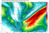
In that image specifically the left exit region over the upstate into west central ncWhere's a good spot to be under that streak?
uh, no, not needing much moisture at all for this. most all of northern half of ala getting .05 qpf, withe some above .10 and a small area above .15I don't know that we can call all of the runs bogus, but if everything is showing what we are seeing but with little moisture...uh yeah.
Caution peeps now not to freak out over what is showing at the surface.... I'm telling you we have seen this song and dance more than once this Winter. I don't know why models are struggling with precip when we have jet streaks like that but they are.... give me that look we will be fine
Except this time people in Birmingham know its coming so the roads will be treated ahead of time.This system is gonna have some surprises with it. With temps as cold as they are, if models are off by even just a little with the QPF, then this will be 2014 all over again in Alabama. Roads will be gridlocked.
uh, no, not needing much moisture at all for this
I would say most of Alabama north of Birmingham is bet for safe 1-3 inches.You're most likely good in AL, you're going to get a nice little event.
We're just all puzzled about what we're seeing eastward with the looks that we're seeing on the other maps. I'm not centered on where I am, or anywhere else.
can treat some main roads, but not the thousands of non main roadsExcept this time people in Birmingham know its coming so the roads will be treated ahead of time.
The earlier WPC discussion threw out the nam and Euro for being too amped and went with the middle of the road UKMET/Canadian blend.The Nam is now trending toward the GFS the last two runs. Went from neutral tilt cutoff ULL to a flat strung out mess...good for small snows in northern gulf states to make those folks happy, but would essentially shaft Central NC. Hopefully not a trend here. We need that cutoff....
Sent from my iPhone using Tapatalk
Damn. Now someone please tell me how there is no precip under that?Well
Sent from my SM-G955U using Tapatalk
The Nam is now trending toward the GFS the last two runs. Went from neutral tilt cutoff ULL to a flat strung out mess...good for small snows in northern gulf states to make those folks happy, but would essentially shaft Central NC. Hopefully not a trend here. We need that cutoff....
Sent from my iPhone using Tapatalk
Looking at that map, should précis be falling all the way to the gulf coast?Damn. Now someone please tell me how there is no precip under that?
Me and you bothWith what I have been told on here, why this doesn't have more precip produced from it, I really don't know...
I think Jon just said that. Very bad for NCDamn. Now someone please tell me how there is no precip under that?
The earlier WPC discussion threw out the nam and Euro for being too amped and went with the middle of the road UKMET/Canadian blend.

From snow hole to glory, lol, the models just lure you in. A hint might be the way the present snow in Ala. just sort of poofs as it senses the Ga line. I guess we can expect that, and hope for betterDamn. Now someone please tell me how there is no precip under that?
") T
TNot sure why you're saying that because it's pretty clear to me the NAM is trending away from the GFS w/ a slower & deeper s/w at the base of this longwave over the MS valley & is consolidating the vort max over the past few runs...
Webb didn't you make this almost exact argument for more precip before the early Dec. storm, reference the jet streak and what models were showing?
You’re right it is slower and deeper, my thought was just going from a cutoff (which have only been some by Nam and Euro) to a non cutoff solution (despite the slower and dapper progression of the vort) was trending toward something more like the GFS, not that it’s identical by any means.
Sent from my iPhone using Tapatalk
No, I’m with storm fury on this one. 850mb vectors get chaotic at hr 45 in GOM shift from SW to W basically shunting off moisture transport. If the mountains were a big issue, we would likely be having temperature issues east of MTNS.I think the problem here is the mountain elevation. Notice how everyone west of the Applachians gets in on the initial frontal precipitation but once it tries to cross the mountains everything disappears. That's the biggest factor here for folks on the other side IMO. Jets streak or no jet streak, elevation will cripple a system every time
I think the problem here is the mountain elevation. Notice how everyone west of the Applachians gets in on the initial frontal precipitation but once it tries to cross the mountains everything disappears. That's the biggest factor here for folks on the other side IMO. Jets streak or no jet streak, elevation will cripple a system every time