GSP Discussion: Significant Winter Storm, but who knows what where.
Key message 3: A potential winter storm system may impact the area
this weekend but details regarding precipitation amounts and type
remain uncertain. Confidence continues to increase that moderate
overall winter storm impacts could lead to hazardous travel and
power outages.
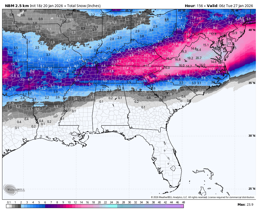
Focus turns to the potential winter storm this weekend and per usual
this is shaping up to be a messy forecast in regards to p-types
(this is the South after all). Timing appears to be late Friday
night into late Sunday night for now, although this is subject to
change. Majority of model guidance is on board with a wintry mix of
snow, sleet, and/or freezing rain. However, p-types will be highly
dependent on the timing of precip. If precip arrives later when the
cold air is in place, we could end up with mainly snow and sleet. If
the precip arrives prior to the cold air, then we will get a mix of
freezing rain, snow, and sleet. The 06Z
GFS depicts less ice and
more sleet while the 06Z
ECMWF depicts more ice and less sleet. The
12Z
GFS is showing precip coming in slower compared to the 06Z
(after the cold air is already in place) and now shows mainly snow
and sleet. For now it appears that we have a high chance for
warning
criteria snow, sleet and/or ice over the weekend. NBM shows the
probability of greater than 4" of snow/sleet ranging from ~20% to
50% across the South Carolina Upstate and northeast Georgia to ~50%
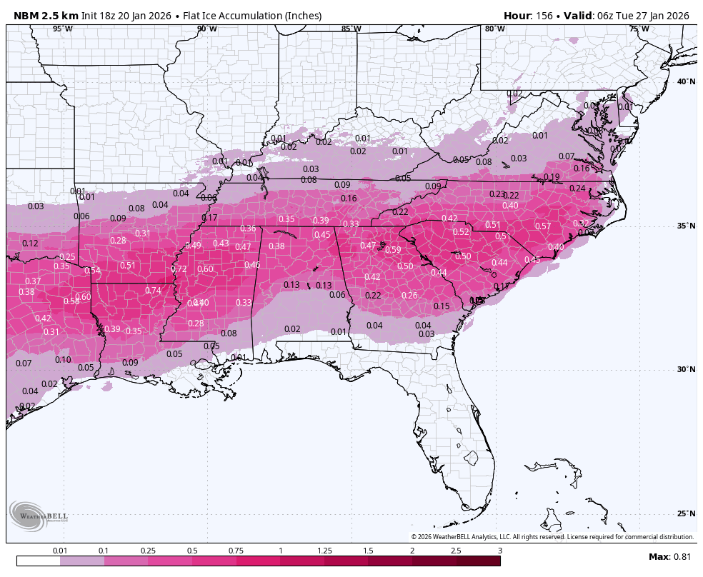
to 80% across most of western North Carolina. NBM also shows the
probability of greater than 0.25" of ice accumulation ranging from
~20% to 40% along and north of I-40 to ~40% to 60% south of I-40.
All this to say, confidence on p-types remains low but confidence of
getting
warning criteria snow/sleet and/or ice accumulations is
increasing. Regardless of exact p-types and amounts, confidence
continues to increase that this system could lead to hazardous
travel and
power outages. Make sure to stay up to date with latest
forecast information in the coming days as this is an evolving
system. Temperatures are expected to remain well below
normal
through much of the weekend.
Key message 4: Dangerously cold wind chills may develop Monday night
into Tuesday morning which could result in
hypothermia or
frostbite
if precautions are not taken.
Snowpack may linger through early next
week due to cold temperatures, which may keep travel issues and
power outages around.
Dry conditions return early next week but cold and well below
normal
temperatures will stick around leading to the possibility of
dangerously cold wind chills as well as lingering
snowpack Monday
night into Tuesday. If the current NBM trends hold, a Cold Weather
Advisory may be needed for the entire forecast area. Travel issues
and
power outages may linger through early next week depending on
how much snow/sleet/ice melts. There is plenty of time for this to
change with this being towards the end of the forecast period so
make sure to stay up to date with the latest forecast information in
the coming days.


 before Gulf Coast Blizzard