iGRXY
Member
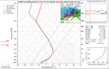
0.5” of ice accrual in the upstate would be likely on this euro run.
We still get 10" in the triangle for a run that amped? Very solid. Hoping we can get a little bump south to increase our margin for errorThose maps are misleading, I learned
View attachment 186394
View attachment 186395View attachment 186396
I tend to lean towards a snowier result north of 85 based on history. Models never seem to capture how stubborn the atmosphere can be along and north of 85.The euro would be a lot of sleet for the upstate but it does eventually flip to ZR and drops at least 0.5” to 0.75” of accrual. The 850’s flip to warm and we will get a real accrual.


That run would be devastating storm for the triangle. 10” of snow and then copious amounts of IP and FZRWe still get 10" in the triangle for a run that amped? Very solid. Hoping we can get a little bump south to increase our margin for error
How is it more amped with the delay in phasing? Early tilt, which seems off to me?We still get 10" in the triangle for a run that amped? Very solid. Hoping we can get a little bump south to increase our margin for error

how much front end snow for the upstate would that have been? Or is it all sleet and freezing rain?0.5” of ice accrual in the upstate would be likely on this euro run.
The baja low still ending up phasing with the northern stream energy. Although IF there are more delays in the baja lows movement then you gotta think phasing may be harder to come by.How is it more amped with the delay in phasing? Early tilt, which seems off to me?
As mentioned by a previous poster, the s/w over the Northern Plains digs a bit more west. This makes the heights over the E CONUS higher. 540 line over PA moved north about 30 miles or so.How is it more amped with the delay in phasing? Early tilt, which seems off to me?


View attachment 186399
Front end thump looks freaking insane for many in NC

What's your take so far Webb on amplification and location of miller-B transfer based on all the copious modeling afoot?The front end thump of snow usually extends further south in these big boy cads too

What's your take so far Webb on amplification and location of miller-B transfer based on all the copious modeling afoot?
[mention]Webberweather53 [/mention] sighting!
Does this thing tick NW… or SE with time?
Sent from my iPhone using Tapatalk

I don't think we escape without a historic storm, whichever way this goes. ECMWF's precip algorithm is also off. Pretty much all of our ZR is IP. Sounding attached below. It does get a little warmer at that 700-850 mb range the next couple frames but as that coastal gets going, it will wrap around cold air from the N and WThat run would be devastating storm for the triangle. 10” of snow and then copious amounts of IP and FZR
I can't wait to see your first call map that captures this line of thinking, especially for the Upstate just south of 85. That is only hope of seeing snow, I guess. I have told many to prepare for a damaging ice storm. Praying for sleet to keep the power.This front end thump is like a super charged version of Feb 2014. Way more cold air and way more precip
I remember that storm up in Baltimore. We got nearly 20" and dryslotted when we lost the thermalsThis front end thump is like a super charged version of Feb 2014. Way more cold air and way more precip
At least another half dozen runs.We're still going to see some back and forth as the baja low interaction get's figured out. Small differences can mean a 100 mi jump on the snow/ice/zr lines.
.gif") .
.That's what I'm thinking too, wonder if this hints at what the physical euro will showImplies the CAD has reached its maximum extentView attachment 186408 on the EURO AI, which has been trending toward the legacy operations.
It will be very interesting to see how this ultimately verifies, and whether AI was given enough training data to even begin to project this accuratelyImplies the CAD has reached its maximum extentView attachment 186408 on the EURO AI, which has been trending toward the legacy operations.
Which means the UKMet may not have been all yhat offThat's what I'm thinking too, wonder if this hints at what the physical euro will show
Or AI has ingested well enough to harness it's realistic press now.Implies the CAD has reached its maximum extent on the EURO AI, which has been trending toward the legacy operationsView attachment 186408 .
Yes, the operational was very similar.That's what I'm thinking too, wonder if this hints at what the physical euro will show

The models usually struggle with the magnitude of the cold air at the surface until pretty close to the event. They don't have it right yet.
Yes, the operational was very similar.
View attachment 186410

It handles surface thermals decentlyQuestion: How well does the NAM do at accurately getting CAD right