• Hello, please take a minute to check out our awesome content, contributed by the wonderful members of our community. We hope you'll add your own thoughts and opinions by making a free account!

Wintry January 23rd-27th 2026

We have pretty good agreement in the major ensembles...GEFS/EPS/EPS-AI area practically on top of each other and precip axis is fairly close too.

We can squint all we want about trends but this looks pretty good for being day 4 out, and really day 3 out for TX/OK.

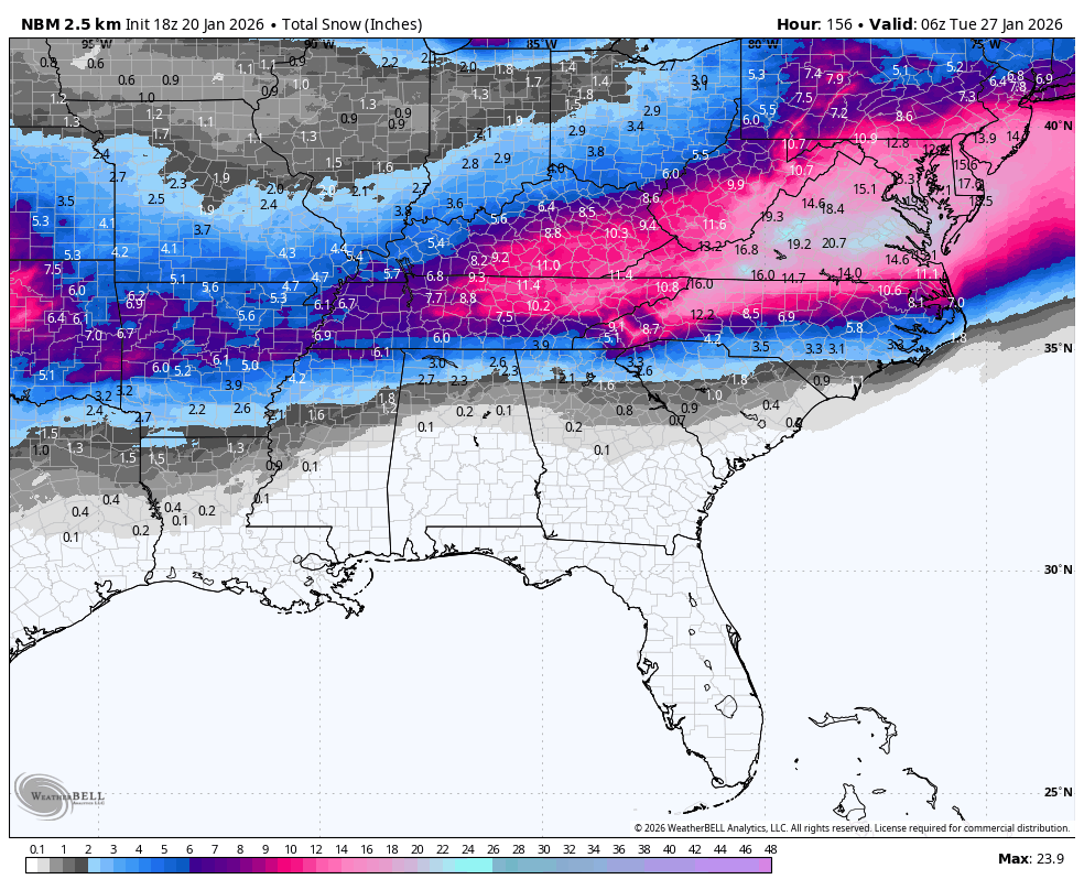
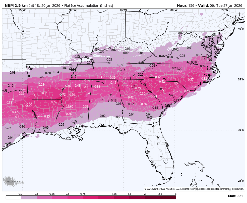
For us in Raleigh a mix of snow/sleet/frzn seems likely and I really hope we can keep that front end snow but that might be iffy for Raleigh.

View attachment 186439View attachment 186440

The Euro AI nailed this past weekend from this range and it did well last year for the 1/21/25 deep south event...that's kind of what I am leaning towards. I find it hard to believe the OpGFS is right but we shall see.
 
For snow in ga/sc/ and even North Carolina it’s all going to come down to how far south and east that initial finger band develops on Saturday.

Experience says it streaks out farther than models show and rips hard… and then behind that band will be the 750mb warm nose and sleet.

My only concern for my location is if it initially develops too far north or not. We need it to blossom from Atlanta to Columbia before slowly pushing north.

The more that cold airmass/high pressure pushes down early will dictate how far south that band initially sets up.
 
Looks good. Here's the latest National Blend of models:


Thats the highest Ive seen the snow packfan on this blended model for us. Puts us right on the 8. Which is my floor / current thinking for total sleet/snow accum. Top # to be decided. I never bet against the euro op inside 96 hours, especially when it lines up with its ens. I'm confident 95 % we get to the 8 total snow & sleet right now, way things stand. Its 8-?? (? part of forecast to be decided )
 
Looks good. Here's the latest National Blend of models:
1769493600-oapHLOjEG44.png

1769493600-Z14jG7Uyui4.png
NBM map with ice accum includes sleet or no?
 
For snow in ga/sc/ and even North Carolina it’s all going to come down to how far south and east that initial finger band develops on Saturday.

Experience says it streaks out farther than models show and rips hard… and then behind that band will be the 750mb warm nose and sleet.

My only concern for my location is if it initially develops too far north or not. We need it to blossom from Atlanta to Columbia before slowly pushing north.

The more that cold airmass/high pressure pushes down early will dictate how far south that band initially sets up.
Definitely watching for that to develop, as it seems to be a feature of many of our other major winter storms that involve strong CAD. It was nice to at least see the ECMWF show a more southern solution on the morning runs today for that initial band, and I have a feeling the short range might show it better.
 
The Euro AI nailed this past weekend from this range and it did well last year for the 1/21/25 deep south event...that's kind of what I am leaning towards. I find it hard to believe the OpGFS is right but we shall see.
This was last week's Euro AI output for the storm footprint around this range...

trend-ecmwf_aifs-2026011500-f084.qpf_006h-imp.conus.gif

Compared to the actual track (+ anything since Sunday I guess but IDK how to get pivotal to go back in time here for observation data)

1768939268835.png
 

Attachments

  • 1768939103348.png
    1768939103348.png
    774.1 KB · Views: 216
Last edited:
Area Forecast Discussion
National Weather Service Peachtree City GA
255 PM EST Tue Jan 20 2026

...Afternoon Area Forecast Discussion...

.KEY MESSAGES...
Updated at 250 PM EST Tue Jan 20 2026

- Very low humidity will lead to elevated fire weather concerns
across the area for the remainder of today, with a lower risk
possible on Wednesday.

- The next significant storm system will arrive as early as
Friday/Saturday, with the potential for high impact wintry
weather to affect north and central Georgia through the
weekend. Please monitor the forecast closely.

--------


.LONG TERM...
(Thursday morning through next Monday)
Issued at 250 PM EST Tue Jan 20 2026

Thursday will begin our very active potentially high impact weekend
of weather for north and central Georgia. Thursday into Friday will
have our first push of rainfall as a quick shortwave pushes through
the main trough over the eastern CONUS. QPF amounts are expected to
amount to between 0.5-1" of precip over northern Georgia.

Pushing into the main impactful weather that is looking to shape up
this weekend, there`s quite a bit to talk about. Saturday into
Sunday we will begin to see the overall troughing pattern begin to
dive south into the southeast while the low pressure system
currently off the Pacific begins to push inward. The timing of how
this low pressure moves is going to in turn factor into how long we
are expecting potential impacts. WPC has informed us that they plan
to do reconnaissance on this low pressure system to hopefully give us
a clearer picture into this event.

Some things to talk about with this event. This is shaping up to be
a potentially high impact event with moderate to major impacts. With
this amount of model consistency in the overall setup we are gaining
confidence that this could be a long duration event as well. With
initiation as early as Saturday afternoon and wintry precip looking
to extend into Sunday evening and potentially into Monday. The WPC
reconnaissance flight should give us a better picture into the
duration of this event. At this point (almost 4 days out) we are
confident that wintry precip will affect north Georgia in areas
north of I-20. The area south of I-20 to Macon and Columbus are a
little more uncertain but models are consistently forecasting wintry
precip for this area as well. A few factors into how much/what type
of wintry precip we receive are the influence of the wedge expected
to take shape and then how far north the front pushes. When it comes
to the wedge, the ensembles were having a tough time over the past
two days resolving the wedge but the ECMWF ensembles are beginning
to depict it better as of 06z and 12z. Current thinking is that snow
will be the main precip type for far north Georgia and wintry
mix/freezing rain will become the main concern for the remainder of
the north Georgia area. There is still a decent shot that we see
this freezing rain transition to more of a snow event as we get into
late Sunday and Monday but that is a bit more uncertainty.

Focusing on the probabilistic information for now.
--> 40-50% chance for 0.5" or greater of ice accumulation through
the weekend for the areas north of I-20.
--> 25-30% chance for 0.75" or greater of ice accumulation through
the weekend for the areas north of I-20.
--> 15-20% chance for 1" or greater of ice accumulation through the
weekend for the areas north of I-20.


--> 30-45% chance for 2" or greater of snow accumulation through the
weekend for the areas north of I-20.

Please take note of how this has ramped up from yesterdays
discussion. What we want you to focus on is being prepared for a
potentially high impact event this weekend. We will likely see more
changes over the coming days but please make sure you have a plan to
endure this event which could include power outages.
 
I'm sorry, but this is a joke imo. Ill let results be the jury. They will never own it, when it fails them.
If this is banter, move it. It'll be the last thing I say. But this is just terrible communication skills. Freezing rain is the most dangerous Winter weather there is.
 
All guidance showing significant icing but a current probability of Major impacts is at 0% in most of GA & SC????????


They have the storm impacts segregated by timeframes. The 0% is for Friday night and early Saturday. Which is correct for 'major impacts'.
 
If this is banter, move it. It'll be the last thing I say. But this is just terrible communication skills. Freezing rain is the most dangerous Winter weather there is.
Follow that up with bitter cold temps, this is a serious situation and must be treated as such. Agree with you man. Btw, Rah NWS already going for low of 4 here Tuesday am. Another aspect of this that has potential to be historic
 
If this is banter, move it. It'll be the last thing I say. But this is just terrible communication skills. Freezing rain is the most dangerous Winter weather there is.
I don't know how you can prepare folks in Atl for what might be coming. No matter what they think, if as depicted, it will be 10 times worse. A life threatening situation....but it might not happen. If you panic a city that big crying wolf, then when the real one comes no one believes you. But people will die. We had people trapped in apartments with no power for weeks. I don't remember having much warning, so I was not prepared, and when I walked up to Peachtree St next to Lenox square the next morning, it was poles and trees down as far as I could see, lines dancing and sparking, and the side roads were worse...... 20 trees and poles in the road in a block. Atlanta is a city of trees and hills.
Stock pile blankets Atl, if nothing else. Chainsaws. Food you can eat cold, and be ready to be scared out of your wits. It was two weeks before I could check on my mother and grandmother across town. She was having to care for her elderly mother using gas logs in the fire place, piles of blankets and a can of sterno to warm up soup. For two weeks. How do you prepare several million people for that? It comes down to the individual's survival skills. They both lived thru the depression, so they knew how to be tough. Many did not.
 
Great trend above Wyoming here if you are rooting for more snow to the south(I think). But it’s the nam, so who knows. View attachment 186456
More separation and retracting whatever that kink was in Saskatchewan. Should be headed for sustained cold press (and maybe some needed cowbell)
 
Great trend above Wyoming here if you are rooting for more snow to the south(I think). But it’s the nam, so who knows. View attachment 186456
Actually seems more connected than Euro at this range, but the trend continues to be interesting
1768941368975.png
1768941383955.png
 
Great trend above Wyoming here if you are rooting for more snow to the south(I think). But it’s the nam, so who knows. View attachment 186456
This, exactly. We want that TPV and NS s/w further east, lowering heights and shunting the SE ridge, esp for those of y'all south of a line from Huntsville to Charlotte to Fayetteville
 
Back
Top