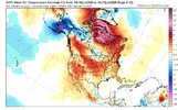
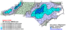
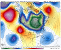
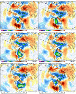
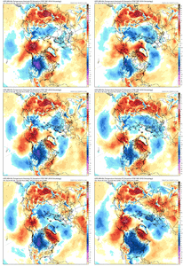
This is great stuff man thank youTheir analogs are colder than their forecast. I think pattern analogs are best used in a general sense. Sometimes useful, and sometimes they moreso highlight extreme scenarios. They've changed their analog maps and correlations over the past year, and it looks like they are just taking analogs back to 1990. But analogs seen here are from Jan 2009, Jan 2025, and Jan 2022, all which were chilly with wintry opportunities. Possible this Jan too, but this is evolving of course and reasons it could break either way for us IMO (good or bad)
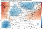
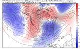
For their forecast, they used:
The official 8-14 day 500-hPa height blend consists of: 35% of Today's 0z GFS
Ensemble Mean centered on Day 11, 35% of Today's 0z European Ensemble Mean
centered on Day 11, and 30% of Today's 0z Canadian Ensemble Mean centered on
Day 11
View attachment 181011
-
Hello, please take a minute to check out our awesome content, contributed by the wonderful members of our community. We hope you'll add your own thoughts and opinions by making a free account!
You are using an out of date browser. It may not display this or other websites correctly.
You should upgrade or use an alternative browser.
You should upgrade or use an alternative browser.
Pattern January Joke
- Thread starter SD
- Start date
trackersacker
Member
That top analog date featured a mid south winter stormTheir analogs are colder than their forecast. I think pattern analogs are best used in a general sense. Sometimes useful, and sometimes they moreso highlight extreme scenarios. They've changed their analog maps and correlations over the past year, and it looks like they are just taking analogs back to 1990. But analogs seen here are from Jan 2009, Jan 2025, and Jan 2022, all which were chilly with wintry opportunities. Possible this Jan too, but this is evolving of course and reasons it could break either way for us IMO (good or bad)
For their forecast, they used:
The official 8-14 day 500-hPa height blend consists of: 35% of Today's 0z GFS
Ensemble Mean centered on Day 11, 35% of Today's 0z European Ensemble Mean
centered on Day 11, and 30% of Today's 0z Canadian Ensemble Mean centered on
Day 11
View attachment 181011
trackersacker
Member
I would take it in a heartbeat. Fun over performer at RDU, they were only calling for maybe an inch or so, but shortwave (maybe Manitoba mauler if I remember correctly) really tapped the Atlantic.
Tsappfrog20
Member
Yes, please!
Sent from my iPhone using Tapatalk
- Joined
- Jan 23, 2021
- Messages
- 4,602
- Reaction score
- 15,197
- Location
- Lebanon Township, Durham County NC
If I remember correctly, I think that’s the storm where Eyewall got that amazing video in Sanford
lol please tell me the purpose of statements like this? Got work to do, etc. it’s weather, we are watching to see what happens. That’s allI get it. but we ain't no time to wollar around & cry about it. We got to bully the atmosphere & make it stop being an idiot. Got work to do.
If you knew me, you would know. But you don’t, so I wouldn’t expect you to understand.lol please tell me the purpose of statements like this? Got work to do, etc. it’s weather, we are watching to see what happens. That’s all
Don’t need to know you to know how ridiculous it sounds. Maybe go “work harder” looking at the models and the will changeIf you knew me, you would know. But you don’t, so I wouldn’t expect you to understand.
packfan98
Moderator
Alright guys. Take it to banter or let it die here.
Already doing it! Thanks for the encouragement!Don’t need to know you to know how ridiculous it sounds. Maybe go “work harder” looking at the models and the will change
Alright guys. Take it to banter or let it die here.
Make sure the same happens with all the let’s rage posts tooAlright guys. Take it to banter or let it die here.
The Obama Inauguration Storm was my first storm as a poster at Talkweather! Good memories, even if it fringed me where I was...I'd be in a little better spot now, though. Luckily, March 2009 happened a few weeks later!
I think that was from the early March 2010 storm. Let me see if I can find it. It was kinda a crappy storm in the Triad since BL temps were above freezing, we were dealing with sun angle, and soil temps were pretty warm, but where it really pounded down towards the sandhills, rates overcame all that; I think more of their rates came after sundown, as well.If I remember correctly, I think that’s the storm where Eyewall got that amazing video in Sanford
EDIT: Good event summary discussing some of this...Jeremy's videos are on page 15 (assuming those are the ones you are referring to), but I can't get those links to work all these years later!
EDIT #2: I think he might've taken the video down based on THIS POST's link not working. Dang! That video was my favorite snow video.
Last edited:
Webberweather53
Meteorologist
It’s really interesting to see that we have already pushed the Pacific mean state to something in between La Nina & a modoki/Central Pacific El Niño.
Notice the recurrent appearance of westerly wind anomalies over the Western Pacific (warm colors).
Unlike most Nina winters that usually end up being very mild in February, seeing this change in the base state already occurring tells me that this winter has a few tricks up its sleeves
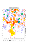
Notice the recurrent appearance of westerly wind anomalies over the Western Pacific (warm colors).
Unlike most Nina winters that usually end up being very mild in February, seeing this change in the base state already occurring tells me that this winter has a few tricks up its sleeves

It’s odd too seeing how the -VP signal doesn’t want to latch on to the Maritime Continent - but these go hand in hand as the low level convergence and uplift isn’t going to be located in the MC with those westerlies thereIt’s really interesting to see that we have already pushed the Pacific mean state to something in between La Nina & a modoki/Central Pacific El Niño.
Notice the recurrent appearance of westerly wind anomalies over the Western Pacific (warm colors).
Unlike most Nina winters that usually end up being very mild in February, seeing this change in the base state already occurring tells me that this winter has a few tricks up its sleeves
View attachment 181016
Mahomeless
Member
Lots of rain there. Would need the HP centered about 300 miles east.Big overrunning event setting up towards the end of the run. View attachment 181019
Webberweather53
Meteorologist
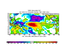
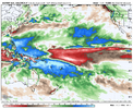
Fwiw, I separated winters that preceded cool ENSO (cold neutral or Nina) >> El Niño transition by “cold” and “warm” Februarys on the East Coast and looked at their OLR/convective anomalies in the Tropical Pacific
IMHO, given how much the Warm Pool has already advanced eastward, this year is leaning towards the “cold” February group with more convective activity or -OLR anomalies (cool colors) over the tropical West Pacific and tropical North Pacific, with a slightly weaker and eastward shifted area of +OLRa (decreased cloudiness, warm colors) near the International Dateline.
-ENSO >> + ENSO transition “warm” Februarys OLR anomalies:
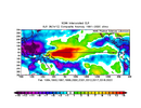
-ENSO >> + ENSO transition “cold” Februarys OLR anomalies:
Euro weekly forecast looks more like the “cold” February composite
IMHO, given how much the Warm Pool has already advanced eastward, this year is leaning towards the “cold” February group with more convective activity or -OLR anomalies (cool colors) over the tropical West Pacific and tropical North Pacific, with a slightly weaker and eastward shifted area of +OLRa (decreased cloudiness, warm colors) near the International Dateline.
-ENSO >> + ENSO transition “warm” Februarys OLR anomalies:

-ENSO >> + ENSO transition “cold” Februarys OLR anomalies:

Euro weekly forecast looks more like the “cold” February composite

Webberweather53
Meteorologist
Fwiw, I separated winters that preceded cool ENSO (cold neutral or Nina) >> El Niño transition by “cold” and “warm” Februarys on the East Coast and looked at their OLR/convective anomalies in the Tropical Pacific
IMHO, given how much the Warm Pool has already advanced eastward, this year is leaning towards the “cold” February group with more convective activity or -OLR anomalies (cool colors) over the tropical West Pacific and tropical North Pacific, with a slightly weaker and eastward shifted area of +OLRa (decreased cloudiness, warm colors) near the International Dateline.
-ENSO >> + ENSO transition “warm” Februarys OLR anomalies:
View attachment 181020
-ENSO >> + ENSO transition “cold” Februarys OLR anomalies:
View attachment 181021
Euro weekly forecast looks more like the “cold” February composite
View attachment 181022
IMHO, we have opened the door to the possibility of 2014 style Feb this year with how the low frequency state is evolving in the Pacific
trackersacker
Member
Wish I could find more documented graphics for East Tennessee. Wanna say we netted 4-6”? But airport doesn’t reflect that.I would take it in a heartbeat. Fun over performer at RDU, they were only calling for maybe an inch or so, but shortwave (maybe Manitoba mauler if I remember correctly) really tapped the Atlantic.
Webberweather53
Meteorologist
It’s odd too seeing how the -VP signal doesn’t want to latch on to the Maritime Continent - but these go hand in hand as the low level convergence and uplift isn’t going to be located in the MC with those westerlies there
While I have felt very confident in El Niño developing later in 2026 for months now, I was pretty unsure if we would see this base state change away from La Nina show itself in time to change the outcome of late winter.
It has certainly become apparent to me over the Holidays that it is already changing
trackersacker
Member
Say lessIMHO, we have opened the door to the possibility of 2014 style Feb this year with how the low frequency state is evolving in the Pacific
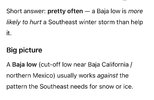
Baja low stays back = big dog. Baja low gets involved = warm.anybody’s guess here View attachment 181023
ChatGPT how often does the Baja low do the opposite of what is needed for a SE winter storm?Baja low stays back = big dog. Baja low gets involved = warm.
trackersacker
Member
Ok now we’re talking
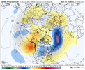
Height pump out front. Unless we roll the ol’ preverbal southerly bowling ball into a wagon wheel of coldlol didn’t expect it to be so honest.
View attachment 181024
That is how you get that frigid air around Alaska down here. Nice wide trough, too.
trackersacker
Member
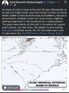
At least he didn’t go off on that corny little plug he always has for “some of our best snows have been in late February and March” .Bradley trolling hard on this fine Saturday evening View attachment 181026
Yeah Brad. Let me unpack that for you. Any snow that late in the season melts in 5 minutes. What we really care about is the next 5-6 weeks. Spare us.
Or option C, all roads lead to badBaja low stays back = big dog. Baja low gets involved = warm.
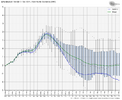
Coldest Jan 7th+ for Chicago lows on GEFS thru today’s 18Z:
1/2 12Z +25
1/3 0Z +25
6Z +21
12Z +19
18Z +15
So, the GEFS mean coldest low at Chicago on the 18Z is a whopping 10 F colder than it was just 18 hours ago and is actually now slightly colder than the 12Z EPS’ 17. The normal Chicago low is for then ~18. So, the source for potential cold in the SE has gotten sig. colder.
This colder GEFS was largely related to a stronger -WPO, -EPO, and -AO.
Last edited:
Check out how much colder the week of Jan 12-18th (week 2) has gotten on the GEFS from 0Z to 18Z run:
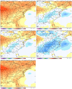
All 5 of the major indices improved for week 2. But the biggest improvement was for the WPO, which is coming just after a huge rise in it between the 0Zs of 12/31 and 1/3:
12/31 0Z WPO: strong -WPO
Look how cold the Canadian source region was then for 1/11-15:
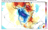
1/3 0Z WPO: had risen sharply to ~neutral and was a big reason why the Canadian source region had warmed so much
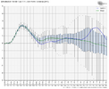
Look how much warmer Canada had gotten for 1/11-15:
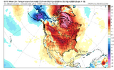
1/3 18Z WPO: big drop since 0Z
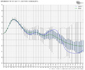
Canada during 1/11-15 has cooled back a good bit from today’s 0Z with the WPO drop:


All 5 of the major indices improved for week 2. But the biggest improvement was for the WPO, which is coming just after a huge rise in it between the 0Zs of 12/31 and 1/3:
12/31 0Z WPO: strong -WPO

Look how cold the Canadian source region was then for 1/11-15:

1/3 0Z WPO: had risen sharply to ~neutral and was a big reason why the Canadian source region had warmed so much

Look how much warmer Canada had gotten for 1/11-15:

1/3 18Z WPO: big drop since 0Z

Canada during 1/11-15 has cooled back a good bit from today’s 0Z with the WPO drop:
