-
Hello, please take a minute to check out our awesome content, contributed by the wonderful members of our community. We hope you'll add your own thoughts and opinions by making a free account!
You are using an out of date browser. It may not display this or other websites correctly.
You should upgrade or use an alternative browser.
You should upgrade or use an alternative browser.
Pattern January Joke
- Thread starter SD
- Start date

LukeBarrette
im north of 90% of people on here so yeah
Meteorology Student
Member
2024 Supporter
2017-2023 Supporter


What in the heck
ducketta27
Member
Whatcha think
Sent from my iPhone using Tapatalk
Stormlover
Member
Usually, not always.At least he didn’t go off on that corny little plug he always has for “some of our best snows have been in late February and March” .
Yeah Brad. Let me unpack that for you. Any snow that late in the season melts in 5 minutes. What we really care about is the next 5-6 weeks. Spare us.
LukeBarrette
im north of 90% of people on here so yeah
Meteorology Student
Member
2024 Supporter
2017-2023 Supporter
GFS is showing a wild scenario that would make sense in the coming pattern. A deep trough can bring snow for some and none for others. The tilt and timing of the system has to work a lot in your favor to get it to work however.Whatcha think
Sent from my iPhone using Tapatalk
LukeBarrette
im north of 90% of people on here so yeah
Meteorology Student
Member
2024 Supporter
2017-2023 Supporter

Hall of fame gfs image right here
Yes it’s 300 hours out
But always fun to see
Stormlover
Member

Can we start a thread for this mega wedge? I need some action 
UNCSC
Member

Alaska has had their fun it’s gonna be our turn late Jan-Feb
Brent
Member
Geez nearly the entire Euro run is above normal here
I'm about to cancel my model subscription haha
I'm about to cancel my model subscription haha
J1C1111
Member
I wouldn't put much stock into the very end of the euro run the way models are to get everything sorted out. Probably right where we want it at this range the way things have been going lately with all the flip flopping. Just trying to stay positive. I hate to see it to.
accu35
Member
That’s the thing, it’s the end of the run. “Long range” it will change. Let’s focus on the cold before thatThe Euro looks like Hot garage at the end of the run! Geesh!
tennessee storm
Member
What’s fun bout that . Just be dry n coldView attachment 181062
Alaska has had their fun it’s gonna be our turn late Jan-Feb
Would be cool if this did something... ya know with it being peak Winter climo & all.
.png")
.png")
Webberweather53
Meteorologist
My guess is we end up looking more like the AI ensemble suites when all is said & done.
Cross-polar flow w/ -EPO will favor a deeper Hudson Bay vortex than the traditional models (esp the GEFS) are currently showing.


Cross-polar flow w/ -EPO will favor a deeper Hudson Bay vortex than the traditional models (esp the GEFS) are currently showing.
It's good & bad. You got a ridiculous amount of cold that will likely set up for areas that have been cold, but it just seems like we enter a period in the 2nd half of January where it stays stupid cold to the North, warmer to the South & a tight slightly wobbling around boundary in between. That boundary will probably be an active Winter storm corridor. Which basically aligns with the 3-4 week outlook from the CPC. That leaves us further South begging for left over CAD set ups as cold air oozes down East of the mountains or as a trough finally digs, we are left over with NW flow snow & a cold dry day East of the mountains.My guess is we end up looking more like the AI ensemble suites when all is said & done.
Cross-polar flow w/ -EPO will favor a deeper Hudson Bay vortex than the traditional models (esp the GEFS) are currently showing.
View attachment 181065
View attachment 181066
Good news is there is a lot of cold air not to far away, just need dots to connect.
Webberweather53
Meteorologist
When it comes to deep western troughs in the extended range actually verifying, I’m at the point where I’ll believe it when I see it.
A mean ridge axis over the Gulf of Alaska into Alaska usually favors more of a Plains to Upper Midwest trough
A mean ridge axis over the Gulf of Alaska into Alaska usually favors more of a Plains to Upper Midwest trough
Webberweather53
Meteorologist
It's good & bad. You got a ridiculous amount of cold that will likely set up for areas that have been cold, but it just seems like we enter a period in the 2nd half of January where it stays stupid cold to the North, warmer to the South & a tight slightly wobbling around boundary in between. That boundary will probably be an active Winter storm corridor. Which basically aligns with the 3-4 week outlook from the CPC. That leaves us further South begging for left over CAD set ups as cold air oozes down East of the mountains or as a trough finally digs, we are left over with NW flow snow & a cold dry day East of the mountains.
Good news is there is a lot of cold air not to far away, just need dots to connect.
When you’re dealing with these big +TNH looks, subtle shifts in the longwave pattern lead to very outsized changes in sensible impacts. A small tweak can take you from what looked like a sure fire spring day to the icebox in a hurry.
Usually, when we get winter storms in these patterns, they end up being large scale warm advection & overrunning events and we rarely see them coming beyond the medium range, and the models underestimate them in the short term.
More times than not in these patterns, the cold ends up pressing further south and east than forecast in the extended range. I’m old enough to remember this was a common theme even back in 2013-14. A warm pattern suddenly flipped to a really cold one once we got inside day 7
Webberweather53
Meteorologist
It’s important to remember going forward the rest of the way this winter that handling strong, shallow Arctic air masses is not a strong suit of global model forecasts. This is one of the reasons why oftentimes these air masses end up sneaking further SE in this type of pattern
I mentioned that very thing yesterday. It almost always happens. And like you said, the propensity for the models to continually place a trough out west at the end of their runs, only to correct, is hilarious.It’s important to remember going forward the rest of the way this winter that handling strong, shallow Arctic air masses is not a strong suit of global model forecasts. This is one of the reasons why oftentimes these air masses end up sneaking further SE in this type of pattern
Either way, other than the continued lack of fantasy storms, I don’t see anything disastrous in the overnight guidance. At all.
As you said, a couple of small-scale tweaks and you go from spring to deep winter in a hurry, with a winter storm bearing down on you, seemingly out of nowhere. We've been in MUCH worse shape than this.
I seem to remember how the February 2014 storm or the back to back storms like some of us had, everything kept trending colder basically right up to go time. I think the important thing I noticed from the overnight ensembles is that cold is close byWhen you’re dealing with these big +TNH looks, subtle shifts in the longwave pattern lead to very outsized changes in sensible impacts. A small tweak can take you from what looked like a sure fire spring day to the icebox in a hurry.
Usually, when we get winter storms in these patterns, they end up being large scale warm advection & overrunning events and we rarely see them coming beyond the medium range, and the models underestimate them in the short term.
More times than not in these patterns, the cold ends up pressing further south and east than forecast in the extended range. I’m old enough to remember this was a common theme even back in 2013-14. A warm pattern suddenly flipped to a really cold one once we got inside day 7
CNCsnwfan1210
Member

Look at the adjustments the GEFS has made in 48 hours on the 06z run
Sent from my iPhone using Tapatalk
Yes, fantasy storms would be nice. It’s IMO the beginning baby steps of tracking.I mentioned that very thing yesterday. It almost always happens. And like you said, the propensity for the models to continually place a trough out west at the end of their runs, only to correct, is hilarious.
Either way, other than the continued lack of fantasy storms, I don’t see anything disastrous in the overnight guidance. At all.
As you said, a couple of small-scale tweaks and you go from spring to deep winter in a hurry, with a winter storm bearing down on you, seemingly out of nowhere. We've been in MUCH worse shape than this.
But I do like the fact that we will likely have a massive cold pool of air just North of us ready to be dislodged
packfan98
Moderator
Narrow path to victory here, but there’s more than one BIG DOG in the bunch.

Mahomeless
Member
- Joined
- Oct 17, 2023
- Messages
- 900
- Reaction score
- 2,158
How is that trolling when it’s true?Bradley trolling hard on this fine Saturday evening View attachment 181026
This is the way.Narrow path to victory here, but there’s more than one BIG DOG in the bunch.
View attachment 181067
NCWeatherNow
Member
If im not mistaken, 2014 February had a large amount of temperature swings before and after the big ice storm, even into march we had a cooldown which had zrWhen you’re dealing with these big +TNH looks, subtle shifts in the longwave pattern lead to very outsized changes in sensible impacts. A small tweak can take you from what looked like a sure fire spring day to the icebox in a hurry.
Usually, when we get winter storms in these patterns, they end up being large scale warm advection & overrunning events and we rarely see them coming beyond the medium range, and the models underestimate them in the short term.
More times than not in these patterns, the cold ends up pressing further south and east than forecast in the extended range. I’m old enough to remember this was a common theme even back in 2013-14. A warm pattern suddenly flipped to a really cold one once we got inside day 7
Cad Wedge NC
Member
Because it hasn't happened yet and he is implying that it certainly will... Also, he is quick to point out every model run that supports his warmist/no snow agenda.... need I say more?How is that trolling when it’s true?
The guy's got a track record in this particular behavior. It goes back years.How is that trolling when it’s true?
trackersacker
Member


 I’ve got a feeling there’s something brewing out in the 9-10 day range.
Way out there, but it's pretty.

NCWeatherNow
Member
Would suppression be a concern with a setup like this?

Looks good to meWould suppression be a concern with a setup like this?
View attachment 181084
rburrel2
Member
Biblical banger setting up at the end of the gfs ai run. Love to see it.
CNCsnwfan1210
Member

LOL
Sent from my iPhone using Tapatalk
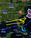
NCWeatherNow
Member
Wouldn't the storm track look something like this?Looks good to me
Attachments

One weenie's suppression is another's perfection. Just saying.Wouldn't the storm track look something like this?
NCWeatherNow
Member
Yeah I still consider that mid January storm good, even though I personally got 0.4" because areas in SE NC got around 5-7 inchesOne weenie's suppression is another's perfection. Just saying.