Wulfer
Member
I do a lot of lurking but, I post more in the winter period. I'm like a wolf that comes down from the mountain. Chattanooga is a fun place to watch in the winter!
I take it as a good sign that we are even getting some fantasy storms right now for December. Means things are going the right direction.Boy if the CFS could ever be right, Id cash out with the 12/1-12/2 Southernwx forum special it advertised at 0Z. Then the artic dump coming down the plains week before Christmas.


i'd be lying if i said i wasn't at least a little intrigued by the cold showing up beyond this late next week push. its out there, but man its loading up and ready to drop somewhere out of canada

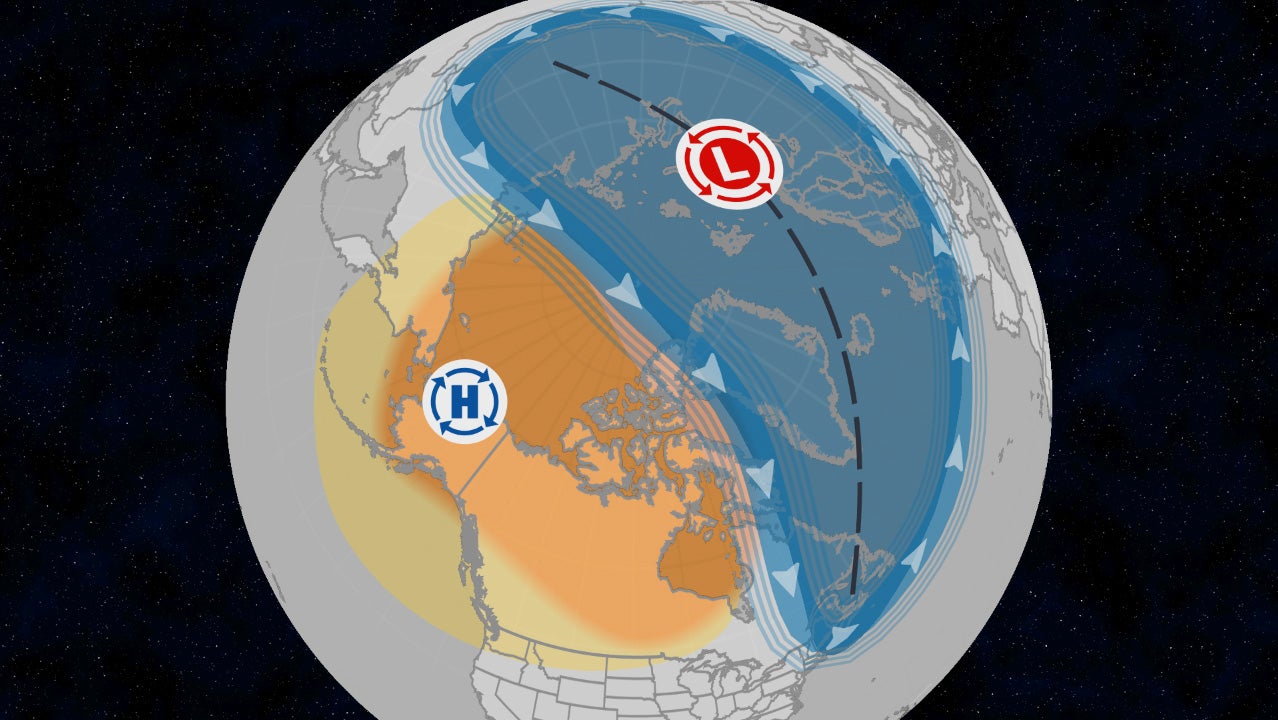
Is that coming from the SSW?It’s happening!
I guess it’s a combo of the PV split/warming and the movement of MJO into phases 7,8, and 1. Cold should start up here thanksgiving weekend and progress to the SE as we head into mid DecemberIs that coming from the SSW?
CFS & the CMC ensemble & GFS ensemble all showing that same fantasy storm right now for beginning of December for VA/NC and northward -- and right now it means next to nothing but if it is still showing up in a weekI take it as a good sign that we are even getting some fantasy storms right now for December. Means things are going the right direction.

Like this??CFS & the CMC ensemble & GFS ensemble all showing that same fantasy storm right now for beginning of December for VA/NC and northward -- and right now it means next to nothing but if it is still showing up in a week

I'd expect the effects from that to lag by a few weeks.Is that coming from the SSW?
 #winning

Agree, I like it as an upper outlier. It's probably too amplified, but the good news is that the really weak MJO models probably aren't amplified enoughThe GEFS is probably overcooking this MJO event a bit as it tends to do in the west pacific, but these kind of zonal wind anomalies over the Pacific coupled with the collapsing -IOD and reversal of Indonesian Throughflow probably spell the end for La Niña.
The amplitude just screams an 8/1 crawl for a few weeks right as we approach the winter solstice. Bring it!MJO model progs:
-11/18 GEFS/EPS runs similar to yesterday day by day along with good progression into 7(GEFS) and well into 7 (EPS).
-11/17 extended EPS remains consistent with recent runs with it getting into 8 on 12/14. But the big news is that the extended GEFS is its most progressive yet and with it actually moving into 8 a day earlier than the EPS (12/13).
At RDU/BWI since 1974 for the 23 three+ day long Dec phase 8 periods averaged out: lots of variation but with solid tendencies
-78%/61% of Dec phase 8 were cold
-Compare that to only 22%/13% that were mild
-Phase 8’s three+ day long periods have averaged 5 days with the longest being 13 days
-Phases 1 and 2 have also averaged cold at BWI but with again lots of variation but with solid tendencies
Based on all of this as well as a typical couple of weeks+ lag of cold in the E US after an SSWE, I’m hoping for cold domination to start in the E US around Dec 15th. Until then, I expect mild to dominate.
11/17 GEFS extended:
View attachment 176803


 weather.com
Yep! Raging deep into December and still wondering when the cold is coming!We are going to rage deep into the night this Winter.

You must eat greenbean casserole.Yep! Raging deep into December and still wondering when the cold is coming!


Hate the stuff actually!You must eat greenbean casserole.
It’s happening!

I like greenbean casserole.You must eat greenbean casserole.
The GEFS is probably overcooking this MJO event a bit as it tends to do in the west pacific, but these kind of zonal wind anomalies over the Pacific coupled with the collapsing -IOD and reversal of Indonesian Throughflow probably spell the end for La Niña.
Agree, I like it as an upper outlier. It's probably too amplified, but the good news is that the really weak MJO models probably aren't amplified enough


I agree that the ext-GEFS with its 3-3.5 amplitude phase 7 is very likely too amped. Looking back to 1974, there have been 32 three+ day long Dec phase 7 periods. Of those, only one, 12/27-31/1996, was as strong as these recent GEFS progs and it was very mild in the E US:
View attachment 176822
Compare that to the extended GEFS prog:
View attachment 176823
Based on my studies, the coolest phase 7 Dec periods in the E US have tended to be on the weaker side.


Prolonged multi-day wind reversal with the SPV on today’s Euro
Sent from my iPhone using Tapatalk
 Bradley is all in. So is Jimmy. God speed, boys

Somebody broke Brad p ? Holy ----

Yeh man... He is getting blasted right now... pretty bad.CJ starting the season aggressive. Full court press View attachment 176872
Idk I don’t really see anything to outlandish in what he’s saying. Am I missing it? Just some cold around thanksgiving and possibly some snow for a few areas.Yeh man... He is getting blasted right now... pretty bad.
Well, it's not that post. It's another post he did yesterday.Idk I don’t really see anything to outlandish in what he’s saying. Am I missing it? Just some cold around thanksgiving and possibly some snow for a few areas.


