Shaggy
Member
Foresee me making the 20 minute ride to some beaches this weekendVery wet eastern 1/3 and even tries to get some 40mph gust inland (we all know how that usually works out though)
Foresee me making the 20 minute ride to some beaches this weekendVery wet eastern 1/3 and even tries to get some 40mph gust inland (we all know how that usually works out though)
Yep. If this thing decouples it'll weaken fairly rapidly but its a recipe for a true mess since a shallow decoupled system is more likely to drift S or WIcon seems to have taken a step towards the euro with a SW drift
yeah i can't pretend to have tracked the rain potential super hard but i know i was hearing more about the potential late last week than i am now. even seen some discussions about severe wx possibilties. now looks like just a backdoor fropa with a few showersepic trend on the EPS for tomorrow from .5-1 to .005-.01


Welp looks like the threat of a thread killed this oneView attachment 175398
How much for PhillyCheck 18Z Icon
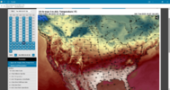
There is no way it’s going to be in the mid 90s in Mid October in Georgia, Alabama and South Carolina.This is what the highs for the first day of deer season look like. Needless to say, this will be miserable weather to hunt in. A cold front does sweep through and knocks twenty degrees off of the high temperatures the next day.
We have a recurring typhoon that should put a trough over the east and I think models will pick up on it later than usual imo. Quick shot of cooler airEuro has been stupid this summer. The retrograding system was dependent upon a phase with a shortwave diving through MO and a ridge building over the top. It has been showing similar stuff all summer out in time only to correct as we move in.
Likely we get a partial phase at least but farther north, keeping the bulk of the precip along/east of 95. Coastal sections up through the mid-Atlantic look to take it on the chin. Persistent onshore flow and now another offshore storm will continue to batter the coast with flooding and beach erosion.
Thank you. These posts of the GFS are worthless. It routinely does this in summer and when we transition into fall. Every single year it keeps 90’s and 100’s going well into October which doesn’t happen.There is no way it’s going to be in the mid 90s in Mid October in Georgia, Alabama and South Carolina.
This giving flashbacks to last months system that was supposed to dump on C/ENC, with FW issued for a few spotty showers. Models really have been horrendous with ULL and coastals this year it seemsHow much for Philly
at least you're not JonesvilleThank you. These posts of the GFS are worthless. It routinely does this in summer and when we transition into fall. Every single year it keeps 90’s and 100’s going well into October which doesn’t happen.
There is no way it’s going to be in the mid 90s in Mid October in Georgia, Alabama and South Carolina.
Maybe it will generate some afternoon T storms from instability, so we can get some rain around here. But most likely a dry heat incoming, 3 day stretch of mid 80's. Lower Miss valley/ mid west, looks to take the brunt.Euro AI looking like July fry the middle of Oct


We need an oof reactionEven with the cold front we still stayed above normal
We suck
We need an oof reaction


Yeah pleasantly surprised, might pick up .25It’s raining

.2 but .2 more than I expected lolYeah pleasantly surprised, might pick up .25
Lots of upper-mid 30s in Iowa todayEven with the cold front we still stayed above normal
We suck
Even with the cold front we still stayed above normal
We suck

I hear that we typically don't want a -nao in October. I know there are exceptions to the rule.Starting to think the 2nd half of October -nao might be a real thing. -nao precursor cutoff is getting within 5 days but the mjo doesn't support the -nao until p4/5. Might be the models rushing the pattern change idk