beanskip
Member
Did I miss the AIFS summary?
I'm hearing that GDOT is brining roads north/along of I-20 tommorow.Orange County, NC DOT is already applying brine to roads here.
.png")
View attachment IMG_1701.jpegNot sure if anyone posted this already, but FFC briefing is out on YouTube:
NWS Atlanta Winter Weather Briefing - 1-8-25

There are only 4 members on there, a lot more to go, you can't judge it at all at that point, it's just starting. Edit: looking at the whole thing, it has gone down some from earlier, but it's not done well in previous events I checked.FWIW, SREF total snow mean for HSV continues its march downwards.
View attachment 161396
That graphic makes me legitimately concerned about downsloping reducing snow totals in my area in Huntsville. The wind from east would support that theory. Am I crazy? that graphic even shows the higher amounts on the ridge tops here and then nearly a 2" drop off immediately west. Its only about 700' higher though.
This it the culprit, ptypes showing rain.FWIW, SREF total snow mean for HSV continues its march downwards.
View attachment 161396

Most interesting slides I saw from the video.Not sure if anyone posted this already, but FFC briefing is out on YouTube:
NWS Atlanta Winter Weather Briefing - 1-8-25


Cold rain.. I projected cold rain and freezing rain for mby last week. Looks like that is coming to fruition.This it the culprit, ptypes showing rain.
View attachment 161399


Looks like some discontinuity between RAH and GSP?
Watching the HRRR play catch up with the 500mb energy is going to be a thing of beauty!can we just take a min to appreciate this look. 36hr on the latest HRRR. Been so long.
View attachment 161403


It is the long range hrrr but nothing else to look at. Hr 40 and cranking
View attachment 161407
Moved alittle futher SE too.Surface low off the LA coast
Sent from my iPhone using Tapatalk
That's a strip of heavy snow to. Right along I-20. Ripping fatties!
 front end thump is thumping

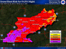
Seems about right to me. Although I question those 3-4" numbers to the north (not sure there's going to be enough QPF). We got the northern stream press I had anticipated, but not in the way I thought. Instead of amping up the system, it flattened it lol.
It’s going to look even better when it realizes the energy at 500mb further south.
Yeah I think it may be more of a stripe across the RAH CWA than that map indicates. Closer but not identical to some of those euro clown mapsSeems about right to me. Although I question those 3-4" numbers to the north (not sure there's going to be enough QPF). We got the northern stream press I had anticipated, but not in the way I thought. Instead of amping up the system, it flattened it lol.