WolfpackHomer91
Member
this might increase qpf over NC I would think?
Yea, but you gotta ride the line to get best rates. Whoever gets right on the pink line will have highest totals.
Sent from my iPhone using Tapatalk
this might increase qpf over NC I would think?
Given my location and the large majority of current modeling I could just about walk to either side of that line.Yea, but you gotta ride the line to get best rates. Whoever gets right on the pink line will have highest totals.
Sent from my iPhone using Tapatalk


850s touch colder, need this trend to continueNAM still ugly but a smidge colder, take improvements wherever you can get them


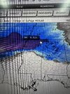
We need a bigger onset hit to rapidly cool the columnFor the RDU folks, look at the 3k NAM, not the 12k. At one point, early on, it showed RDU at 32/17 with rain.
Wow, the NAM's N.C. QPF output fell off a cliff. Kind of the "anti-amp" wants it gets to the Carolinas.
Yeah I've never seen this before. This is a Miller A gulf low going from TX, snow, GA snow, and dies in the Carolinas. Just never seen it before. Take me back to the Miller B days where we get a huge amped storm but a great High funneling in a super CAD. Miller B is the new old school, lol.
Anyone got the AI euro?
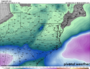
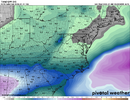
Euro AI Snow trendDon't think I saw it mentioned but the ECMWF-AIFS had a little bump in precip for most areas at 12z.

I don't have the snow map but from looking at the qpf and temps it's going to be similar to 6z probably shifted 1 or 2 county layers northAnyone got the AI euro?
This thing is locked in

I mean, that’s below the 90% confidence minimum FFC had in the briefing