NBAcentel
Member


Personally, I like the AO and NAO to be as low as possible, but with a southern stream underneath. That's the Nirvana pattern in my book, but it's really rare of course.The -AO can be a good thing if it's not too extreme like it was a couple years ago. We only had very cold and dry conditions as a result so I'm not rooting for anything extreme. The current projection does take it low but not as extreme as it was in 2022.
View attachment 157731


I was expecting worse looking at the mean. Still looks good for the 10th-12th View attachment 157832View attachment 157831


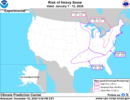
I wonder what they see that we don't see! Even metro Atlanta is in the slight risk.
An actual forecaster looks at the pattern instead of just taking literally what the current models are showing. They aren’t saying it will happen, but that there is a small chance. Which is exactly correct in my professional opinion.I wonder what they see that we don't see! Even metro Atlanta is in the slight risk.
Thank you. fun time ahead. Interesting to see what the GFS cooks up for dinner in a few.An actual forecaster looks at the pattern instead of just taking literally what the current models are showing. They aren’t saying it will happen, but that there is a small chance. Which is exactly correct in my professional opinion.
As the TV mets like to say, pattern recognitionI wonder what they see that we don't see! Even metro Atlanta is in the slight risk.
That's some great news if things line up right. The strong -AO also keeps places further south in the game as well.Personally, I like the AO and NAO to be as low as possible, but with a southern stream underneath. That's the Nirvana pattern in my book, but it's really rare of course.
Here are some examples of such a pattern that produced multiple winter storms across the south. Note the lack of a strong +PNA ridge
Personally, I like the AO and NAO to be as low as possible, but with a southern stream underneath. That's the Nirvana pattern in my book, but it's really rare of course.
Here are some examples of such a pattern that produced multiple winter storms across the south. Note the lack of a strong +PNA ridge

Can you KATL?
Can you KATL?

Not too bad...thank you
Took care of it for ya deleted it. I was just making a point that my best storms come with a banana high. All I care about at this range is ensembles I've been around long enough to know not to look at individual op runs 200+ hours out.Lot of banter in here imho. Cold and dry yada yada yada, better suited for the complaining thread.


I don’t think any of us are counting on a big event here. But an inch of snow or glaze of ice would be huge with how starved we are for winter weather. Just something to legitimately track inside day 4 would be awesome.CAD events with surface high centered off the SE US Coast rarely turn into big storms outside the mountains unless you have a ton of cold air already in place (or in-situ) & there's another mechanism to keep it there, like say a big snow pack nearby or already on the ground.
That however is simply not the case here w/ this storm late next weekend into the beginning of the following week.
That doesn't mean you can't get snow/ice, but your ceiling isn't that high.
View attachment 157829
View attachment 157830
Essentially, if we repeat this by this magnitude we're in business I'd think. I really want to see what the euro's got next run and if it too flips. We still have a lot of time to work with.The trend we want is to bury that southern wave, keep it clean at least till it’s around the SE, raise heights around the GLs, and slow down the SE can vortex View attachment 157844
Is that LP really going to plow into the cold press coming down?
Yep there’s some of that front end snow/ice
Sent from my iPhone using Tapatalk
I don’t think any of us are counting on a big event here. But an inch of snow or glaze of ice would be huge with how starved we are for winter weather. Just something to legitimately track inside day 4 would be awesome.
@Rain Cold might have an expert opinion on this matterIs that LP really going to plow into the cold press coming down?
It really wants to get cut off again. Might not be the run but at least it's bailing in TX vs CA.2nd wave looks like it’s going to kick out. Fingers crossed.


Yep, a lot better than 12z at the same time:2nd wave looks like it’s going to kick out. Fingers crossed.