packfan98
Moderator
It’s got some clipper energy from the northern stream diving in. Doesn’t look like it’s going to get together this run though.
We get another small jump like this in those directions and we will be looking at an all snow event with surface temps in the upper 20s, we were very close to holding on to a classic CAD event rooted in to some very cold air up north on that run.The trend we want is to bury that southern wave, keep it clean at least till it’s around the SE, raise heights around the GLs, and slow down the SE can vortex View attachment 157844
Glad to see you’re warming up to this period. I’ve been saying 1/3 - 1/6 for like 10 days now was our first window to watch.Fair. I’ve liked the Jan 6-7 period more than the rest of the beginning of the month for a while now.
I’d love to see this kind of storm appear again or some type of overrunning event after mid month when the cold air has been very well entrenched
Glad to see you’re warming up to this period. I’ve been saying 1/3 - 1/6 for like 10 days now was our first window to watch.
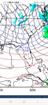
Where does it re-form off the coast grit? Need it at least 'B' on or below the 34th parallel
Ehhhh wrong. You’ve been on the week two train saying week one would be dry northwesterly flow.Ehhhh. You made a big deal out of me saying this had a better signal than the Jan 3-4th clipper system just a few days ago.
Wait a minute. It might work out!It’s got some clipper energy from the northern stream diving in. Doesn’t look like it’s going to get together this run though.
Ehhhh wrong. You’ve been on the week two train saying week one would be dry northwesterly flow.
I have said 1/3 - 1/6 the entire time. You said week two. To the point of dishonestly trying to misconstrue the ensembles and you know it. Now you’re trying to save face.And it is for the most part, especially for this Jan 3-4th system you have been hyping up for several days plus.

I have said 1/3 - 1/6 the entire time. You said week two. To the point of dishonestly trying to misconstrue the ensembles and you know it. Now you’re trying to save face.

For the western Carolinas, NE Ga, and Triad areas this is exactly where you want it two weeks out.It’s cutting across FL, not sure if it’s going to turn the corner or not, if so coastal snow imo
Sent from my iPhone using Tapatalk
Hubby works HVAC for a hospital… with a bunch of old.. I mean old!!! Equipment!! They don’t like for him to get overtime..but unless models change drastically.. he’s heading for a rough week next week!! Numerous other small buildings nearby he also has to serve including a hospice. They normally prioritize.. but this is definitely going to present a challenge..
You called that one right. Well done. Now we just need a little tweaking.i think the GFS is going to phase late and pop a coastal here
It’s not perfect or anything, but it’s in the mix with the other solutions. 850 deg 0 wedges into the PiedmontWhere does it re-form off the coast grit? Need it at least 'B' on or below the 34th parallel


I’ve also been keenly aware that week two was better. I just didn’t dismiss the first opportunity. Live and learn!Oh man, there’s only some potential for some of the strongest cold air in years, if not decades to impact NC during that following week, even without snow cover. Not to mention the signal for snow is still larger than it is during this coming period. I am simply flabbergasted at the error of my ways
I’ve also been keenly aware that week two was better. I just didn’t dismiss the first opportunity. Live and learn!
 . Granted week 2 doesn’t look as amazing in the snow department as it did just a few days ago.
 Please don't clog the thread with your locations in reply to this either.
 docs.google.com
Drop some clown maps!Oh mama… the gefs members are going nuts for the day 7 threat!
There’s really no reason to ignore the initial period as it 1) sets the stage for the next period and 2) there’s a -NAO in place with Arctic air nearby - that’s better than we do 99% of the time. Bird in hand and such…I’m just inherently choosy/picky and I’d rather focus my energy on the potential for a bigger fish
Drop some clown maps!