Belle Lechat
Member
- Joined
- Aug 29, 2021
- Messages
- 1,529
- Reaction score
- 1,215
Agreed. I think too much is made of storm size in regards to surge potential. Will more areas be affected by surge in a big storm with a long fetch? Sure. But you really need those cat 4+ max winds in the eyewall to push a 12-15ft+ storm surge.the usual suspects- dry air and shear. i still maintain that when this thing deteriorates it will deteriorate fast
you can feel it in the air this morning. woke up and the house was sitting at 65 (no heat on). i think it's inevitable dry air gets ingested tomorrow on the southeast side- all models show this- the question to me is how long it can maintain its structural integrity
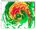
View attachment 152900
the impacts will be similar but i don't agree verbatim with the "the impacts will be the exact same" message- personally i think there's a big difference between a ragged but intact storm coming ashore vs. a half-icane that has been decaying for a little bit
While the southern eyewall may not make it, the eastern eyewall will likely be bolstered upon landfall by frictional convergence at the surface and for TB that may be enoughAgreed. I think too much is made of storm size in regards to surge potential. Will more areas be affected by surge in a big storm with a long fetch? Sure. But you really need those cat 4+ max winds in the eyewall to push a 12-15ft+ storm surge.
This is setting up to be a widespread 6-9 foot surge which will be very bad, but I don’t think 12-15ft materializes anywhere unless the southern eyewall stays in tact(not likely).
While the southern eyewall may not make it, the eastern eyewall will likely be bolstered upon landfall by frictional convergence at the surface and for TB that may be enough
Yea, if you’re looking for worst case scenario that would probably be it. Tampa Bay is oriented perfectly to funnel in water from an eastern eyewall impact.While the southern eyewall may not make it, the eastern eyewall will likely be bolstered upon landfall by frictional convergence at the surface and for TB that may be enough

right turn you mean?Yeah I'm curious if that left turn happens as it approaches the coast. It's been hinted at on several runs and that could be worst case scenario for Tampa if it happens. They definitely aren't out of the woods yet

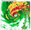
Yeah, that looks a bit south of previous GEFS runs. Drives me nuts the HWRF is insistent on its northern route vs everything else.So any change in landfall has bigger effects on my weather on the east cost, but does this look a little bit of a south shift in the GEFS?
View attachment 152909
If I remember correctly, the times it's been stubborn like that, it's had the closest forecast to landfall point. But take me with a grain of salt....I'm an Hwrf fan so I tend to look over it's faults.Yeah, that looks a bit south of previous GEFS runs. Drives me nuts the HWRF is insistent on its northern route vs everything else.
The HWRF can't simply be ignored but latest short term movement of Milton has been east and even wobbled a little south of due east again since the last center fix.If I remember correctly, the times it's been stubborn like that, it's had the closest forecast to landfall point. But take me with a grain of salt....I'm an Hwrf fan so I tend to look over it's faults.
It's 80 miles from Tampa to Crystal River, so even shorter across water. It could go either way.The HWRF can't simply be ignored but latest short term movement of Milton has been east and even wobbled a little south of due east again since the last center fix.


