Just a slight change from the 12z lol

Just a slight change from the 12z lol

1 step forward 2 steps back on the drought here. Especially since i whiffed the last 2 days while areas around got 1+. Pgv is pushing a 9 inch deficit now

Maybe this one can buck the trend and over perform.What a Plume headed up toward the SE this weekend!
Not going to lie this one is giving me fits to try to pin down. I can see how we could over perform with more widespread 2-3 inch totals and areas of 3-5, I can also see how a legitimate minimum of precip between US1 and I95 happens and we walk away with .1-.25. First real test will be tomorrow to see if the initial moisture surge and weak fgen can give us a solid band of rain or if it dies between coastal convection and better forcing to the west
This is going to happen because that's how this year has gone for MBY.Not going to lie this one is giving me fits to try to pin down. I can see how we could over perform with more widespread 2-3 inch totals and areas of 3-5, I can also see how a legitimate minimum of precip between US1 and I95 happens and we walk away with .1-.25. First real test will be tomorrow to see if the initial moisture surge and weak fgen can give us a solid band of rain or if it dies between coastal convection and better forcing to the west
This is going to happen because that's how this year has gone for MBY.
PWATs are quite high and there will be a couple of disturbances moving through the area, which should produce some pretty efficient rainfall. A general 1-3" area-wide is a pretty good bet.Not going to lie this one is giving me fits to try to pin down. I can see how we could over perform with more widespread 2-3 inch totals and areas of 3-5, I can also see how a legitimate minimum of precip between US1 and I95 happens and we walk away with .1-.25. First real test will be tomorrow to see if the initial moisture surge and weak fgen can give us a solid band of rain or if it dies between coastal convection and better forcing to the west
Dreading this. 12:30 kick tomorrow and I’m thinking we might be in the thick of it around thenI like your area tomorrow afternoon to get into some of the deeper convection to be honest. Probably going to be a lot of lightning delays for college football games regionally
I feel you. However, luckily, this morning's 6z is quite different in the long run. Still doesn't swing next week's front all the way east of the Apps, but brings another stronger one down the following week, brings 50s to most north of I20, and gets rid of most of the 90s. Who knows what the ground truth will be by then but nice to see positive changes nonetheless. Summer days are numbered my friend!there aren't any temps in the 50s on the gfs out to 300+hrs wtf. awful.
All we need is a hurricane approaching Wilmington and we wouldn't have any issues blasting a front through the entire eastern seaboard.I feel you. However, luckily, this morning's 6z is quite different in the long run. Still doesn't swing next week's front all the way east of the Apps, but brings another stronger one down the following week, brings 50s to most north of I20, and gets rid of most of the 90s. Who knows what the ground truth will be by then but nice to see positive changes nonetheless. Summer days are numbered my friend!
This won't happen because it has a deluge in Chatham.This is going to happen because that's how this year has gone for MBY.
I'm sorry, Shetley is unavailable right now. But if you would please leave your name, number, and a brief message, he will return your call when he's back in the office. Thank you.


Have you received a lot of rain? Nothing but an occasional splatter here so far, and it looks as if the western portion of the state did okay, but notta here in Chatham.How did the models miss on this forecast for NC. Up until last night there was not a lot of precip forecasted for our state. What changed?
What are things you’ll never get to say during a winter storm for 1000$ , Alex!Total forecast for my area was 2-4 inches; already over 1.4 and coming down steady. I think I might bust high.
not true fall air, but then again its September so i don't expect true fall air for another few weeks. It's a step in the right direction and it's better than what we've been dealing with.Next week looks nice with cooler air. Such a relief.

Are you back In Carrollton? Asking for a friend?not true fall air, but then again its September so i don't expect true fall air for another few weeks. It's a step in the right direction and it's better than what we've been dealing with.
DDnot true fall air, but then again its September so i don't expect true fall air for another few weeks. It's a step in the right direction and it's better than what we've been dealing with.
There was also one on Pawley’s Island earlier as well
84/72 sweatember it is
Pretty decent airmass change from lastnight till today. Much more humid.84/72 sweatember it is
83/74 here and the sun just popped out. Hope the warmth and humidity pay off. Pwats 2.2-2.3 are crazy high for the time of year without a tropical system if anything gets going should be pretty decent rain rates84/72 sweatember it is
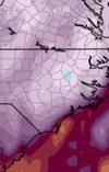
Where exactly on the US1 corridor?18z hrrr is going off along the US1 corridor some near/over 10 inch totals by morning
South wake, Chatham, Lee, Moore doesn't get up your wayWhere exactly on the US1 corridor?
Had a bunch of showers but it's those small beady rains so it's hard to judge how much we are gettingI had a good shower already and looks like more to come.