Looking at the newer model runs, it’s gonna be puking snow 85 and N, in Upstate, then probably mostly sleet with colder temps being modeled! If I lived Lauren’s to CAE, I’d get the generator ready!GSP starting to mention higher wind gust now for much of its CWA. This is going to very serious for many of us unless we somehow get sleet rather than ZR. They now think the warm nose will go all the way to even Avery county now.
-
Hello, please take a minute to check out our awesome content, contributed by the wonderful members of our community. We hope you'll add your own thoughts and opinions by making a free account!
You are using an out of date browser. It may not display this or other websites correctly.
You should upgrade or use an alternative browser.
You should upgrade or use an alternative browser.
Wintry Jan 15-16 Winter Storm Discussion & Obs
- Thread starter SD
- Start date
GSP gonna get smoked! Biggest snow since 2011!Gonna be lots of graupel in this View attachment 106096View attachment 106098
My hubby turned on TWC and it said state of emergency for GA. SC, NC and I believe VA.... Interesting...I had no idea...
NBAcentel
Member
These hrrr soundings just north of CLT. geez gonna be puking snow, snow is gonna be very rimed as well given how high the DGZ is 

Yep announced that yesterday eveningMy hubby turned on TWC and it said state of emergency for GA. SC, NC and I believe VA.... Interesting...I had no idea...
We are going to see a white ground regardless of when it comes in .. temps at 27 with all sorts of precip whether it’s ice or snow it will give the area a white tint as it buildsI'd like to see it trend earlier than that to start--preferably before sunrise so we can increase the chances of seeing white on the ground for longer.
ForsythSnow
Moderator
URGENT - WINTER WEATHER MESSAGE
National Weather Service Peachtree City GA
346 PM EST Sat Jan 15 2022
GAZ022-025-027-034-035-160500-
/O.UPG.KFFC.WW.Y.0003.220116T0500Z-220117T0500Z/
/O.EXA.KFFC.WS.W.0002.220116T0500Z-220117T0500Z/
Forsyth-Jackson-Madison-Gwinnett-Barrow-
Including the city of Lawrenceville
346 PM EST Sat Jan 15 2022
...WINTER STORM WARNING IN EFFECT FROM MIDNIGHT TONIGHT TO
MIDNIGHT EST SUNDAY NIGHT...
* WHAT...A mix of snow, sleet, and freezing rain, changing to
mainly snow showers by Sunday afternoon. Up to 1/4 inch of ice
accumulation can be expected with locally higher amounts
possible. 1 to 2 inches of snow is also expected. Gusty winds
over 35 mph at times will make for very hazardous conditions.
* WHERE...Forsyth, Jackson, Madison, Gwinnett and Barrow
Counties.
* WHEN...From midnight tonight to midnight EST Sunday night.
* IMPACTS...Plan on slippery road conditions. Icing on trees and
powerlines may result in some power outages.
* ADDITIONAL DETAILS...Strong wind gusts along with any ice and/or
snow accumulation will likely bring trees and powerlines down.
PRECAUTIONARY/PREPAREDNESS ACTIONS...
If you must travel, keep an extra flashlight, food, and water in
your vehicle in case of an emergency.
bud006
Member
Winter Storm Warning now for for Forsyth, Gwinnett, and Barrow counties.
--30--
--30--
Man, that's near hurricane-force gust modeled in N. Ga.By the way those wind gusts on the HRRR would be something else. Probably too high, but even if you take off about 10-15 MPH you still get 40-45 mph wind gusts.View attachment 106097
If anything near to these values materializes, this is going to be a storm talked about for years.
Latest WRF model:???
Snowflowxxl
Member
FFC saw the NAM and HRRR ?
21 years, new plug and that ole briggs and stratton still runing like day 1.
Flakes starting at Boone 4300ft. Just started spitting
Flakes starting at Boone 4300ft. Just started spitting
Flurry
Member
Seems to be trending better board wide…Don’t know how the ice people feel about it though
Sent from my iPhone using Tapatalk
Sent from my iPhone using Tapatalk
BufordWX
Member
Wow!

We now have (Winter related) Warnings and Advisories in every state in the South, except TX and FL. (Even LA snuck in a few counties in the NE corner.)
Good luck everyone!
farleydawg792
Member
Wonder if Clarke and Oconee will go under late this evening. Maybe ice storm warning to be honest.Winter Storm Warning now for for Forsyth, Gwinnett, and Barrow counties.
--30--
Meanwhile, the ULL wants to go to the Mardis Gras  This pig is still digging!
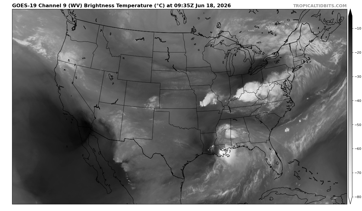
 www.tropicaltidbits.com
This pig is still digging!
Water Vapor Satellite Loop for United States | Tropical Tidbits
United States Water Vapor Satellite Loop
www.tropicaltidbits.com
iGRXY
Member
Got a feeling it may be south of guidanceMeanwhile, the ULL wants to go to the Mardis Gras
Water Vapor Satellite Loop for United States | Tropical Tidbits
United States Water Vapor Satellite Loop
bud006
Member
Wonder if Clarke and Oconee will go under late this evening. Maybe ice storm warning to be honest.
Just watched NWS briefing (was delivered at 2 p.m. and now is available on their YouTube channel. They did mention Ice Storm Warning being a possibility, along with WS Warning and High Wind Warning.
Wow!
Absolutely staggering. Not sure I’ve been under one of those. This might get bad y’all
Lee County AL
Member
Meanwhile, the ULL wants to go to the Mardis Gras
Water Vapor Satellite Loop for United States | Tropical Tidbits
United States Water Vapor Satellite Loop
Does this mean the ULL is more south than expected ??
I just took a peek, and guidance has been ticking south all day.Got a feeling it may be south of guidance
accu35
Member
You can see a little SE movement at the end, but still isn’t it still further SW than modeled?Meanwhile, the ULL wants to go to the Mardis Gras
Water Vapor Satellite Loop for United States | Tropical Tidbits
United States Water Vapor Satellite Loop
NBAcentel
Member
925s are trending colder as we get towards veri ?
Cary_Snow95
Member
38.7/23.9 Holding steady thru most of the day
I think
I think it's safe to yes...a little. It may not translate east, but so far, so good.Does this mean the ULL is more south than expected ??
Lee County AL
Member
Meanwhile, the ULL wants to go to the Mardis Gras
Water Vapor Satellite Loop for United States | Tropical Tidbits
United States Water Vapor Satellite Loop
Does this mean the ULL movement indicate chance of snow increase for Montgomery Alabama and Columbus Georgia ? Thanks
ATLwxfan
Member
Atlanta is so close to being a much bigger deal. Gonna be fascinating to watch in about 12 hours

3k NAM Kuchera ratio still pretty light for much of ATL metro. It’s the least impressive of the mesos but let’s see because the 18z was an uptick.
Sent from my iPhone using Tapatalk
Anyone have the last time atlanta was under a high wind warning?
Z
Zander98al
Guest
Looks like the surface low as of 3pm off of mesoanalysis. Is currently situated around New Orleans.
NBAcentel
Member
Normally we could handle these winds but they are coming in that “Hugo like direction”
I would think so, yes. For those areas, the stronger, the better too. Heck, for most of us for that matter.Does this mean the ULL movement indicate chance of snow increase for Montgomery Alabama and Columbus Georgia ? Thanks
GaSnowhound
Member
Yeah those clouds are thickening g up too. I was in Madison (Morgan co) few min ago and car therm never got above 46. I think this is our high and hopefully crashing hard from this point.Creeping south&west again. It's going to be a sleepless night.
45.5 240pm. That should about do it for the high.
GaSnowhound
Member
Good luck! Should be fun up there!!Snowing here in Hendersonville. And so it begins ?
If I lived in Greenville SC and had this forecast, I would need new pants! TR going to get 12”+
BufordWX
Member
Hrrr continues with the colder trends. Snow really starts breaking out around midnight.
bnathanb1982
Member
I'm in Walton about 3 miles from Barrow County which is in WSW...I feel pretty goof where I'm at. Mother nature sure as hell doesn't stop according to county lines or what counties are under a watch/warning thankfully ?Wonder if Clarke and Oconee will go under late this evening. Maybe ice storm warning to be honest.
GSP finally folds! Latest snow map and ice on their Facebook page!