Triplephase93
Member
I agree with this. Seemed to happen with the last system as well.Cold air in the these storms seem to always struggle over the Cumberland Plateau to get into Chattanooga, Dalton, and Chatsworth when it is borderline.
I agree with this. Seemed to happen with the last system as well.Cold air in the these storms seem to always struggle over the Cumberland Plateau to get into Chattanooga, Dalton, and Chatsworth when it is borderline.
I agree, but different setup from earlier this week. We are already suppose to get down to 32 tonight.Cold air in the these storms seem to always struggle over the Cumberland Plateau to get into Chattanooga, Dalton, and Chatsworth when it is borderline.
Clouds came in earlier.My high busted 3 degrees low today. High was 48 not 51… interesting
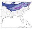
Nice of the GFS to put the bullseye over Van Buren country on the cumberland. I did not think we would top Sunday nights 7 inches, but who knows.18z GFS
A lot of sleet in that.Nice of the GFS to put the bullseye over Van Buren country on the cumberland. I did not think we would top Sunday nights 7 inches, but who knows.
I'm in Ooltewah and we busted on the high end. We hit 55° today. I "think" we were supposed to be at 52° for the high. I believe the airport officially hit 53° for the high. Speaking of the airport, for years I believe Chattanooga should move the official reporting station away from there. In general the airport usually runs warmer than surrounding areas and it really doesn't accurately depict all the various temperatures in our area. They need a more centralized location in my opinion or more than 1 reporting station like some other cities have.I believe we busted 2 degrees here. Would be nice to hang around 34 tomorrow instead of 36/37
Interesting. It’s going to be close tomorrowI'm in Ooltewah and we busted on the high end. We hit 55° today. I "think" we were supposed to be at 52° for the high. I believe the airport officially hit 53° for the high. Speaking of the airport, for years I believe Chattanooga should move the official reporting station away from there. In general the airport usually runs warmer than surrounding areas and it really doesn't accurately depict all the various temperatures in our area. They need a more centralized location in my opinion or more than 1 reporting station like some other cities have.
Sent from my moto z4 using Tapatalk
0.25” accretion is warning criteria, but 0.25” of freezing rain calling from the sky won’t lead to anywhere near 0.25” of accretion in many/most cases, especially if the precipitation is heavy or if temperatures are near freezing.that is a little more ice than i would like. you would think anything over .25 of ice would be winter storm criteria


I'd say to really see something go on up to Manchester or McMinnville TNGonna chase in north Bama tomorrow. When is the heaviest precip coming in?


that map includes all frozen precip though. Here is the snow


I’m sure it’s only for areas above 1500’Honestly not even sure why we are under a WWA.
This storm gonna go Boom for north Alabama.Encouraging words from the NWS Huntsville tonight:
Area Forecast Discussion
National Weather Service Huntsville AL
954 PM CST Wed Jan 5 2022
.NEAR TERM...(Rest of tonight)
Issued at 954 PM CST Wed Jan 5 2022
Clear skies continue across much of the area. A few high clouds
continue to push southeast into Cullman county and northeastern
Alabama at this hour. Very light or calm winds are in place in most
locations of northern Alabama and southern middle Tennessee as well.
These conditions, along with some drier air advecting into the
region, have allowed temperatures to drop into the mid to upper 30s
in most locations. In some locations, despite some drier air moving
into the area, temperatures have dropped down to dewpoint values and
some lowering visibilities are occurring as the boundary layer
saturates and fog formation is starting. Think this will mostly
happen near and east of the I-65 corridor. Around or just after
midnight, think that even drier air will push southeast ahead of the
resurging cold front dropping further south from southern Missouri.
This should put an end to any fog development then.
Complicated setup continues over the southeast this evening, as a
surface low that was over eastern Texas continues to move to the
east southeast over the last few hours. 3 hour pressure change trends
suggest this will continue. As mentioned earlier a strong cold front
with very dry air behind it is re-surging southward over the last
few hours. We will be watching this very closely overnight into
Thursday morning. Could see some isolated to scattered rain or
freezing rain push into northwestern Alabama with this forcing around
4 to 6 AM. However, the bulk of the precipitation and wintry weather
should push east into the area after 6 AM on Thursday.
The further south this front gets, the better chance lower dewpoints
and freezing temperatures around daybreak and into the day on
Thursday will combine with strong low/mid level forcing to produce
significant wintry weather across the area. Models hint that strong
forcing seen in guidance could lead to higher freezing rain or
snowfall totals over portions of the area, especially northwestern
Alabama east to near the I-65 corridor and in southern middle
Tennessee. Kept close to previous forecast with colder overnight
lows than more recent guidance with lows dropping into the upper 20s
to lower 30s around daybreak. Also, kept previous forecast for snow
totals (1-2 inches) in southern middle Tennessee and freezing rain
totals (0.01 to 0.20 inches) elsewhere, but subsequent shifts may
need to increase these amounts.
I think they are saying that NW AL and southern middle Tennessee totals may increase, nothing in there about north Alabama in general, to include the Huntsville metropolitan area.This storm gonna go Boom for north Alabama.
Not really, they say this"I think they are saying that NW AL and southern middle Tennessee totals may increase, nothing in there about north Alabama in general, to include the Huntsville metropolitan area.


Pouring snow here , silver dollar flakes ground solid white already here west Tennessee . I’m on west end of the meso put out by spc 1 to 2 inch per hour rates now fallingLooking good for Tennessee. Yall stay safe out there and enjoy!!! My mother was born in Rockwood outside of Knoxville. Go Volunteers!!!!
Likely will be a higher impact event then if rain washes the treated roads.Moisture outpacing the cold so far….rain and sleet well up into middle TN where snow was supposed to be falling….
Ughhhh it's all frozen in Tennessee right now.Moisture outpacing the cold so far….rain and sleet well up into middle TN where snow was supposed to be falling….
")
Interesting....the 2 people in southern TN I have spoken with says all rain, as do multiple mPing reports....guess they all wrong?Ughhhh it's all frozen in Tennessee right now.
very possible once the coldest of the air rushes in....Likely will be a higher impact event then if rain washes the treated roads.