D
Deleted member 1449
Guest
I’m with ya!I’m just wanting to see snowflakes fall.
I’m with ya!I’m just wanting to see snowflakes fall.

D12 looking pretty chillyI don't hate where the end of the Euro was going. At least the big Epac ridge is gone and there's some blocking setting up near the pole. Patience will continue to be required, I guess.
View attachment 99349
Bro huh??? Pattern look absolutely fine. We’re finally getting cold air into the mix and the specific storm details are obviously not going to be clear until u get into near 200 range … absolutely nothing to be worried about right now if you want cold and or snow in January in the SE … y’all do remember what models used to be showing like a week ago right?! Wall to wall torch? Anything is better than that and the January pattern to me looks very different than that ..January may end up being downright ugly for much of the lower 48 overall (the keyword is overall), with the exception being the far northern tier. Certainly, there is not much encouragement for the SE in the foreseeable future with respect to a genuinely cold/snowy pattern.
Bro huh??? Pattern look absolutely fine. We’re finally getting cold air into the mix and the specific storm details are obviously not going to be clear until u get into near 200 range … absolutely nothing to be worried about right now if you want cold and or snow in January in the SE … y’all do remember what models used to be showing like a week ago right?! Wall to wall torch? Anything is better than that and the January pattern to me looks very different than that ..
Typically southeastern snowstorms aren’t found in a frigid cold pattern. We need many factors to line up. It’s all about storm tracks and positioning. Good trends are close.What is it about the upcoming pattern that looks good to you that would support a genuinely cold and snowy pattern in the SE? What evidence is there to conclude that such a pattern will actually materialize beyond a brief cold shot?
The pattern looks like a flaming paper bag of dog ? if you're watching for a sustained cold and wintry pattern for the SE. Warm-ups and CADs are in store for probably the next two weeks. Beyond that, things could go either way.What is it about the upcoming pattern that looks good to you that would support a genuinely cold and snowy pattern in the SE? What evidence is there to conclude that such a pattern will actually materialize beyond a brief cold shot?
Also to go with that, punting January away on 12/27 is laughable. These are the types of looks you are going to get during a potential pattern change. Did everybody sit here and think every single model run was going to be a beautiful look and deliver cold to the east? That doesn't happen. As great as those cold runs looked I knew as soon as the models flip back to showing an iffy pattern again in the long range the jump off the ledge crowd would get going again. There's several things in our favor for cold in the east but we need more consistent showing in the pacific and that's the key word here. Consistency. I guarantee you at some point within the next couple of days you will get another cold look on the models and then you'll probably get another warm flip again. It's typical during boring upper air patterns much less when a potential pattern change could be happening.The pattern looks like a flaming paper bag of dog ? if you're watching for a sustained cold and wintry pattern for the SE. Warm-ups and CADs are in store for probably the next two weeks. Beyond that, things could go either way.
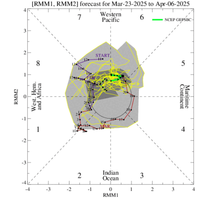
But to be fair, nothing guarantees January being a dud. And likewise, no amount of hopium means it will get cold and snowy either. Around D10, you can see some changes taking place. The image i posted above illustrates that.
From the latter frames, you can see a few legitimate options for a transition to a better pattern. You can also see how it could break the other way.
All that said, it is hard to get through the month of January without a couple of chances for ice and snow. It's that way for a reason. So, being somewhat optimistic and realistic, we'll probably see a transition to a week or two period that will feel, and possibly look, like winter.
Yeah I agree. Honestly, everyone has a right to make a prediction. And persistence is hard to beat. And people said the same thing about punting December near the end of November. December turned out to be a train wreck. But, I do think January will end up being a different story.Also to go with that, punting January away on 12/27 is laughable. These are the types of looks you are going to get during a potential pattern change. Did everybody sit here and think every single model run was going to be a beautiful look and deliver cold to the east? That doesn't happen. As great as those cold runs looked I knew as soon as the models flip back to showing an iffy pattern again in the long range the jump off the ledge crowd would get going again. There's several things in our favor for cold in the east but we need more consistent showing in the pacific and that's the key word here. Consistency. I guarantee you at some point within the next couple of days you will get another cold look on the models and then you'll probably get another warm flip again. It's typical during boring upper air patterns much less when a potential pattern change could be happening.
I couldn't agree more. The pattern is definitely changing around the 3rd. But other than for a day or two possibly we'll below average it looks average to slightly below average which doesn't work here. And big warm ups in between. My hope is it countinues to progress in our favor. It could go anywhere from a good pattern for us to zonal and flood the whole country with Pac air or back to the trash we're seeing now. It's a waiting game.The pattern looks like a flaming paper bag of dog ? if you're watching for a sustained cold and wintry pattern for the SE. Warm-ups and CADs are in store for probably the next two weeks. Beyond that, things could go either way.
But to be fair, nothing guarantees January being a dud. And likewise, no amount of hopium means it will get cold and snowy either. Around D10, you can see some changes taking place. The image i posted above illustrates that.
From the latter frames, you can see a few legitimate options for a transition to a better pattern. You can also see how it could break the other way.
All that said, it is hard to get through the month of January without a couple of chances for ice and snow. It's that way for a reason. So, being somewhat optimistic and realistic, we'll probably see a transition to a week or two period that will feel, and possibly look, like winter.
I agree but I think it will take until 2-3 week of January. I don’t know ---- about weather but I do have 37 years of experience seeing patterns evolve. At the end of the day we just have to hope.The progression on the MJO is very encouraging, and one would think the model runs will start to reflect that going into early January. Just my amateur analysis.
I would tend to agree January will end up normal at best and likely above average. Realistically any chance at a below average month this winter is going to be hard to come by in the SE. I can't speak for anyone but me but I'm only expecting windows of a week or two here or there to get winter weather. That's where I've been since the start.I'm not punting away January. I said it "may" end up being downright ugly for much of the country. I don't know how it will turn out, but if I were a betting man I'd bet on a warmer than average January for a large swath of the CONUS.
Not to mention sun angle being higher as well.I want to be the first to point out how grossly warm the soil temps will be after days-on-end in the 70s.
This is the number 1 reason why I am not as concerned that we aren't going to get at least a couple weeks of cold and at some point a storm is going to undercut the cold. The MJO is not the only thing influencing the pattern but when it's not on your side you're going to feel just how much of a potential good pattern can get cut to shreds. Last year we maintained a -NAO for most of the winter but the MJO stayed in terrible phases which help push the pacific into the garbage. It looks like we can keep at least a weak - AO/-NAO through January as of right now and you get the MJO is phase 7/8 or the COD in January and I will take my chances all day with that.The progression on the MJO is very encouraging, and one would think the model runs will start to reflect that going into early January. Just my amateur analysis.
Do What? Wow. smhJanuary may end up being downright ugly for much of the lower 48 overall (the keyword is overall), with the exception being the far northern tier. Certainly, there is not much encouragement for the SE in the foreseeable future with respect to a genuinely cold/snowy pattern.
Not this sun angle thing again. Winter just started, the sun angle is fine.Not to mention sun angle being higher as well.

#DirtyMayThe teleconnections this morning were very meh with only the -PNA being the only constant. The seasonal outlook models do some show us getting cold....in May
We've seen heavy snow overcome that many times. Don't be a debby downer.I want to be the first to point out how grossly warm the soil temps will be after days-on-end in the 70s.
Thank you I’m tired of all the dislikes I was getting for trying to breakdown this winter on the “when”. Some were screaming since November 1st and some have forecasted winter storms already for us. I’m sticking to my forecast and breaking down winter into segments even if it is “delayed” I think people want to know. I haven’t ruled out that back sided winter just yet either.I hope you guys score in the next 3-3.5 weeks or so, pattern is about as favorable overall as it’s gonna be this winter imo.
.png")
.png")
LOL!I would say due to the “heat wave” this week any chances of ice would be a self limiting process with roads being fine well into February. For snow, we can still get the grass covered but snow covered roads are gonna be a difficult task until at least Feb10 or after.
Yeah I agree. Honestly, everyone has a right to make a prediction. And persistence is hard to beat. And people said the same thing about punting December near the end of November. December turned out to be a train wreck. But, I do think January will end up being a different story.

StopWouldn't it be even more difficult to get snow covered roads after Feb 10 due to a much higher sun angle ?
It's the other way around. Sun angle actually provides lift for convection, hence heavier snow showers, more accumulation.Wouldn't it be even more difficult to get snow covered roads after Feb 10 due to a much higher sun angle ?
Smdh....we don't need zero to have snow on roads. I've always had snow stick on the roads especially in the night and in shady areas during the day. Got two inches in an hour last year around 4 in the evening with Temps in the 50s all day until the snow moved in.I say that with experience even Boone NC the roads would melt most snow storms under 6” fairly easy atm. We need major cold near 0 that would certainly help snow road conditions. Hoping for major cold air last day or January into February.