Blue_Ridge_Escarpment
Member
Beech Mtn specialSeeing some 6 inch hues showing up on the 12Z GFS run for Sunday. I like the trends.
View attachment 97015
Ray’s Weather Center taking noteSeeing some 6 inch hues showing up on the 12Z GFS run for Sunday. I like the trends.
View attachment 97015
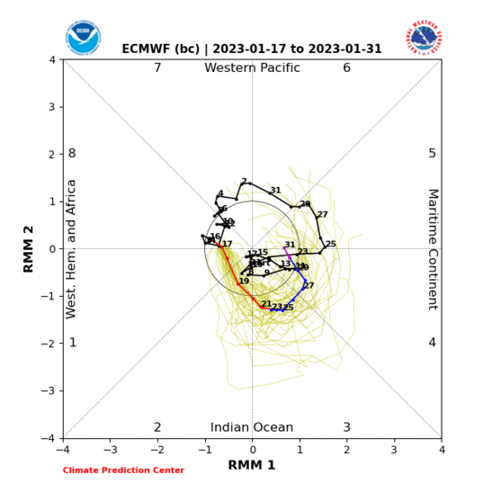
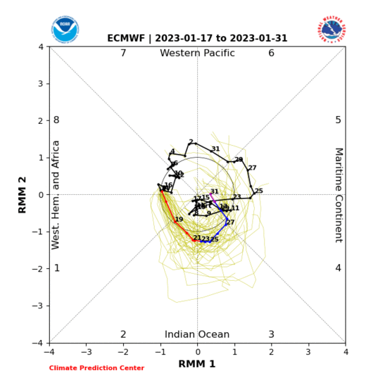
Lagged MJO phase composite evolution and NWP suggest the way we break out of this pattern is via -NAO. You can see the precursor signs of it setting up over Scandinavia and northern Africa + Mediterranean on the EPS & GEFS and slow moving MJOs like this one are more likely to trigger -NAOs barring it actually moves into the W hem. Probably still no less than a week, maybe two from this point in the model from a legit favorable pattern change, but that's generally consistent w/ what I've been thinking for the last week or so timing-wise.
Also we'll have to keep an eye on that vortex over NE Siberia (+WPO), if that extends eastward more towards the Aleutians, it could set off a -EPO in the late portion of the month &/or early January.
View attachment 96950


As a librarian, I am here for the citationsI've mentioned this a few times the past few days in passing...
....but, after reading some more on this, I'm starting to feel much more confident that the evolution of the subseasonal pattern going into the last few days of December and into early January has -NAO written all over it & thus real potential for a favorable pattern change for cold/snow in the SE US
While there's a link between West Pacific MJO (phase 6-7) & -NAO, slow moving West Pacific MJO events that also occur during La Nina winters are far more likely to produce a -NAO. -NAO in these situations tend to occur via retrograding blocking highs over N Europe (Scandinavian pattern that becomes -NAO), while El Nino -NAOs often are more in-situ based.
Here's a few pieces of literature worth reading if you're into learning more about some of these quirks in subseasonal prediction that are pretty applicable to what we may encounter over the next several weeks.
"Our results suggest that the NAO response to the MJO is in fact due to the more slowly propagating episodes"
"The slow episode changes for NAO− in phase 6 are much larger than seen previously for all episodes, indicating that this response is dominated by slow MJO episodes"
"For slow episodes, the midlevel height anomaly composite initially shows both the development of the low heights over the Gulf of Alaska followed by a strong projection onto the NAO+ regime. This strong projection of the composite anomalies is confirmed by a dramatic increase in the frequency of occurrence of the NAO+ regime 15 days following phase 4. The frequency of occurrence of NAO− following phase 6 increases sharply, in agreement with the very strong composite anomaly fields."

"Circulation Response to Fast and Slow MJO Episodes"
https://journals.ametsoc.org/view/journals/mwre/145/5/mwr-d-16-0352.1.xml
We show that the MJO to NAO+ regime tropospheric teleconnection is strongly enhanced during El Niño years, via enhanced Rossby wave activity, and suppressed during La Niña. Conversely, the MJO to NAO− regime stratospheric teleconnection is enhanced during La Niña years and suppressed during El Niño.
The NAO− regime teleconnection via the stratosphere from MJO phases 7–8 is most enhanced and occurring latest during La Niña years, while it is suppressed during El Niño years. The ENSO circulation anomaly modifies the MJO convection, impacting the Rossby waves generated, and their teleconnection pathways to the NAE (North America-Europe) region.
"ENSO Modulation of MJO Teleconnections to North America and Europe"
https://agupubs.onlinelibrary.wiley.com/doi/full/10.1029/2019GL084683

Webber and BAMWX now getting on same page.
Webber and BAMWX now getting on same page.
Off the weed!
That’s gonna be some heavy wet snow in the mountain locales!This reminds me of that March ULL that produced svr ??View attachment 97017
12/28-1/8 seems realistic given years past and how pattern changes are rushedGood to see they've finally realized they may have been too quick w/ this pattern change. It's definitely there (arguably more so now than before), just didn't seem like it would occur by Dec 20 like they suggested several days ago.
Geez the gfs in the strat was pretty crazy ends with almost a split and a new warming event over Siberia that might be the killshot
Nothing says happy holidays like a thunderstorm on December 6th.
To be fair I think we are still technically in the fall severe weather season.Nothing says happy holidays like a thunderstorm on December 6th.
Maybe the azaleas will start blooming soon.I’m telling you, if this isn’t late March, I don’t know what is. Thunder booming outside. Spring is in the air (minus the pollen!)
Sent from my iPhone using Tapatalk
Don’t sleep on that system this weekend , things are starting get modeled some ugly parameters More details as week progressesTo be fair I think we are still technically in the fall severe weather season.

Maybe the azaleas will start blooming soon.
You could be pushing mid 80s on FridayDFW currently has a +14.3*F departure for December
That boy is gonna cutI'm posting this only because I want to look back on the 22nd and see how this panned out. lol. It's a really nice look, setting up for a Christmas miracle, but unfortunately way out there in la la land.

You could be pushing mid 80s on Friday
