I think it's prudent to sound an alarm for New Orleans and for people to get out, but New Orleans is in a much better place than they were 16 years ago as far as surge protection is concerned. The surge protection system is very different than it was for Katrina. It's certainly not immune to surge, but it is much better protected. There are multiple lines of defense to stop surge, and surge is no longer allowed "inside" the city like it was before.
The city as a whole has not sunk an additional two feet. Some areas of New Orleans East and the Lower Ninth/St Bernard parish line have subsided about half that, but on a whole, the city sits on average a couple inches further down than before, and that average is skewed because of the extreme outliers. You'll see news stories mentioning rates of 2-3 inches per year, but that's for small portions of the city.
IMO, the major threat to the city these days is wind and rainfall within the levee systems. I think rain is the biggest and most likely threat. I have a very intimate knowledge of the storwater infrastructure of the city, and I have a little less than zero faith in it. The surge protection and outfall canal pumps are top of the line, but past that it gets scary quickly. An afternoon thunderstorm is enough to flood certain neighborhoods. If a train of tropical moisture sets up in the right spot, good luck. The system is theoretically able to handle 1" of rain in the first hour and a half an inch for every hour after that. At some point, due to crappy pipes and catch basins, the streets begin to act as conveyance. The city even uses 6" of stormwater storage capacity for all the streets in their calculations. It's mind-bogglingly idiotic, but whatever.
There is a possible scenario where a slow moving system keeps surge way up and dumps massive amounts of rain in the city. This would kind of fill up the areas between the lines of defense and outside the lines of defense, and once that area is filled up, it would flow back in to the city. It's a low probability scenario, but not a zero probability. A slower storm coming from a more SE angle increases the probability.
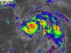
All that said, we thought the city was safe last time. It wasn't. We think the city is safe this time. We all hope it is as Ida is looking like no joke for SELA.
Source:
<-- worked on flood control for a decade in New Orleans following Katrina. I am by now means the end all be all authority, but I do have a pretty in depth knowledge of the water systems in the metro Nola area, especially the east bank portions. It has been six years since I worked in the area, so some of my information could be out-dated.