HSV AFD really hit the points this morning
1. An upgrade to an
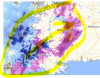
Ice Storm Warning was done across northwest and
much of north central Alabama. This replaces the Winter Storm
Warning. Significant ice accumulations and impacts will be felt in
these areas. Moreover, the predominant precipitation type in these
areas will be freezing rain (with sleet and/or light snow and rain
mixing in at times), depending on your location. Treacherous travel
conditions are expected in these areas with heavy
icing leading to
some tree and
power line damage.
2. A Winter Storm
Warning remains in place for all of southern middle
Tennessee and northeast Alabama. Confidence is still high that
widespread, significant impacts due to ice, sleet, and light snow
accumulations will occur in those areas. However, they will be less
so than areas to the south and west and ice accumulations will be
less as well. Regardless, it is critical for folks in these areas to
take this
warning seriously and be prepared for significant wintry
impacts.
3. The start time of the Winter Storm
Warning for Marshall, Jackson,
and DeKalb counties was moved up to NOW. The reasoning behind this is
that light freezing/drizzle will be moving in early this morning.
Ridgetops could start to see
icing impacts shortly, especially in
Marshall and Jackson Counties. It`s a much more a complex situation
here where valleys are a few degrees above freezing and
ridge tops
are below freezing. However, all locations will see wintry impacts by
later today and especially this evening and tonight.
4. Temperatures will vary during the event, depending on your
location. In fact, a brief change over to rain isn`t out of the
question in areas along and east of Interstate 65. Models continue
to "tease" a warm up to at or above freezing in these areas. While a
warming trend is
likely, the values advertised by the models for a
large chunk of the area are
likely overdone (as they have been for
several days). Thus, we continue to have confidence that most areas
will see significant winter impacts during the
warning window.
5. Freezing rain will begin to overspread most of the region from
the SW over the next couple of hours and impacts will be felt
immediately in areas that are below freezing. The aforementioned
locations in the
Ice Storm Warning will be primed for significant
ice accumulations and subsequently bigger travel and societal
impacts. Expect and prepare for hazardous travel for your morning
commute.
6. Regardless of where you live, hazardous travel impacts could last
well into Tuesday and potentially through Wednesday morning (when we
finally could warm up above freezing). Bottom line: With temperatures
not forecast to rise above freezing in most areas on Tuesday,
persons could be stuck where they are for as much as 24-48 hours.
7. Bitter cold air will filter into the region behind the arctic
front tonight, with temperatures dropping into the Teens late tonight
and Wind Chills in the single digits to near zero degrees in some
places. A
Wind Chill Advisory may be needed in later forecast
updates.
8. Depending on the magnitude of ice accumulations and travel
impacts,
power outages could persist in some rural areas for a few
days. The combination of bitter cold temperatures tonight into
Tuesday will make this particularly hazardous for those that do lose
power. Residents should be prepared and have an emergency supply kit
ready in the event of a long duration
power outage.
Overall the main forecast change was high confidence in ice/sleet
accumulations and less so on snow. Our analysis shows a classic setup
for freezing rain, especially across northwest Alabama and areas in
the
Ice Storm Warning. A warm nose aloft of +5-7C at 850-925
mb
combined with surface temperatures in the mid to upper 20s means
we`re especially primed for
icing in these areas. The window for
ice/sleet accumulations will vary by location, with the morning into
early afternoon being favored in northwest Alabama, the mid/late
morning and afternoon in north central Alabama and southern middle
Tennessee, and the afternoon/evening in northeast Alabama. Regardless
of what
warning type you`re in or the main timing of the impacts,
this doesn`t change our overall message of hazardous and potentially
dangerous winter weather conditions being expected.