Brent
Member
I could be wrong but honestly I still like where we're sitting being bullseyed last week did us no good


Honestly I still like where we're sitting being bullseyed last week did us no good
True.
The precip map was disappointing, but overall the GFS was still a step in the right direction.
As long as we can continue the trend towards a deeper closed ULL and the trough taking a neutral tilt, that's good.
Hour 84 NAM will save us, book itWhy do we suck so bad with surface temps this year? Maybe I just have a bad memory, but I don’t remember tracking terribly many storms in the past that were below freezing at 850 but warm at the surface.
Lack of snow cover to the north is one reason.Why do we suck so bad with surface temps this year? Maybe I just have a bad memory, but I don’t remember tracking terribly many storms in the past that were below freezing at 850 but warm at the surface.
I mean look at how much it's come north since yesterday as far as the thermals go well I've heard from some local people it's the warmest model and if the rates are heavy enough it won't matter
I just hope it doesn't come too north lol
My worst nightmare would be us getting whiffed while Corsicana gets a foot of snow.
Getting missed to the north and west so far is one thing, but getting missed to the south would just be dark sided.
I don’t think that would actually happen, but I’m sure there’s some piping hot warm nose at 750 mb or something, anyways, that doesn’t show up in the main maps.Why do we suck so bad with surface temps this year? Maybe I just have a bad memory, but I don’t remember tracking terribly many storms in the past that were below freezing at 850 but warm at the surface.

Yeah, in the Carolinas outside the mountains we need that tracking over the FL panhandle around Jacksonville or at least Savannah. Not so for AL/MS/TN, though.You can’t get temps below freezing with this type of low track. Not in a million years will it happen.View attachment 63794

Yeah. They don’t need the same angle of cold that we need. I feel like those guys have more ways to score.Yeah, in the Carolinas outside the mountains we need that tracking over the FL panhandle around Jacksonville or at least Savannah. Not so for AL/MS/TN, though.
Now I will say part of me is still skeptical about a real actual snow here for one reason... It's been 5 long years lol
Oh totally I know I got pretty annoyed last week but nothing tops for me watching that snow south of us in 17/18


.png")
.png")
A daytime snow would be so much fun just saying lol
Even my last couple chases were at night
Looks like I may need to snow chase to Dallas hey Brent do you know any great hotels in Dallas to snow chase too? ?Can it just be Sunday alreadyView attachment 63797

Ok Let me get my snow chasing funds back together looks like I’m back in business Dallas here I come lolOh my speaking of February 2010 lmaoView attachment 63807
Ok Let me get my snow chasing funds back together looks like I’m back in business Dallas here I come lol
Oh my speaking of February 2010 lmaoView attachment 63807


That 500mb look, combined with the placement of arctic high and the thermals, is about a good as we can get.
Not even February 2010 had this good of a synoptic setup.
View attachment 63814
View attachment 63815

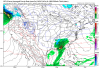
Nice increase for miss and I20/59 northward in Alabama on new gefs..View attachment 63819
Really wish you’d change your handle to SouthTXwx so I won’t keep getting suckered in. ?That 500mb look, combined with the placement of the arctic high and the thermals, is about as good as we can get.
Not even February 2010 had this good of a synoptic setup.
View attachment 63814
View attachment 63815
It's been mentioned a lot by some local people also February 2010 was supposed to be an inch or two lol
I was a big skeptic at first but I mean this seems like a perfect setup if there ever was one again
In theory they do, but we actually average significantly more snow than those areas. We tend to get bigger storms.Yeah. They don’t need the same angle of cold that we need. I feel like those guys have more ways to score.
Really wish you’d change your handle to SouthTXwx so I won’t keep getting suckered in. ?


.png")