Thought we were headed for glory.......
FACK!

FACK!
Warm nose sez, Hai!
Alot, on the board is in decent shape.Gotta get to Friday for this one to even start to take shape.
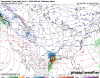
Wow looks like some accumulating snow in Columbia SC.
If we delay that H5 look another 24 hours that will be MS eastward for sure.Eps really cranked up from Mississippi to the west vs 00z
Sent from my iPhone using Tapatalk
This storm has been modeled for so long that it’s easy to forget we’re still five days out.If we delay that H5 look another 24 hours that will be MS eastward for sure.


Middle Tennessee and northern Alabama will like that.it may turn to crap but gfs at hr117 aint bad for the upstate...
EDIT: warms up at 123.

Already heading north. Next.Wow. Lookie here!!!
View attachment 63643


Only if heights didn’t build so much out ahead, this could be a actual Deep South snow, but this thing digs so early and cuts

Only if heights didn’t build so much out ahead, this could be a actual Deep South snow, but this thing digs so early and cuts
Smh
View attachment 63650
how accurate is the new gfs?Wow. Lookie here!!!
View attachment 63643
Yup...We in deep south need that northern piece to cruise through the lakes first.Only if heights didn’t build so much out ahead, this could be a actual Deep South snow, but this thing digs so early and cuts
Smh
View attachment 63650
Only if heights didn’t build so much out ahead, this could be a actual Deep South snow, but this thing digs so early and cuts
Smh
View attachment 63650
Temps better start changing quickly. 18z GEFS is nothing like the EPS. Quiet frankly the GEFS has looked like ? the whole time.


Gotta be some ridging nestled to the east. It can and will cut into a HP.How is that low able to run north with the position of those highs?


.png")