Can someone smarter than me explain the highlighted area, please? Why would that paragraph even be included???
Yo... this storm right now
Oh man hope you’re ok! Definitely send a report into NWS!I just had a pretty large tree fall on my house! First time ever in my life. Damage to eaves/roof. And this is with no big wind. It came down very close to where I was. Huge boom. Scared the crap out of me. Pic is too large to upload.
Glad you are ok! Sorry about your house.I just had a pretty large tree fall on my house! First time ever in my life. Damage to eaves/roof. And this is with no big wind. It came down very close to where I was. Huge boom. Scared the crap out of me. Pic is too large to upload.
You ok man? Take a screen shot of the lic on your phone and then upload the screen shot. That should work.I just had a pretty large tree fall on my house! First time ever in my life. Damage to eaves/roof. And this is with no big wind. It came down very close to where I was. Huge boom. Scared the crap out of me. Pic is too large to upload.
He has to get his core fixed and protected. Again this morning we saw a nice pulse but now that has waned. We should in theory see another pulse up once we get that NE motion. Isaias will then be traveling in parallel to the shear which should help limit its impact.
I think we will see some slow organization today up until landfall. Will probably just start looking good as it makes landfall this evening. We should see a jump up in winds especially around the center as the core breathes some once we see that NE motion.
Of course there is a lot of "I thinks" in there haha
Half inch from that. Gotta think we will keep bubbling these up when the sun comes back outDecent wind lots of lightning and a nice cool down from an oppressive start to the day

Yo... this storm right now

Half inch from that. Gotta think we will keep bubbling these up when the sun comes back out

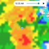
Well I disagree with Webber I think this is the main event for some with ties to the tropical storm. I think as the storm nears, attention will focus East to Raleigh as the atmosphere has been getting worked over since yesterday for areas in the west quad. View attachment 45922
Well I disagree with Webber I think this is the main event for some with ties to the tropical storm. I think as the storm nears, attention will focus East to Raleigh as the atmosphere has been getting worked over since yesterday for areas in the west quad. View attachment 45922
If you edit the picture by cropping a small portion out it should let you upload the photoI just had a pretty large tree fall on my house! First time ever in my life. Damage to eaves/roof. And this is with no big wind. It came down very close to where I was. Huge boom. Scared the crap out of me. Pic is too large to upload.
A few hot towers going up on the NW side of the MLC.....NHC basically says give it some time they think the improving conditions still make this a cane....
.gif")


Yikes granted this is the HRRR but after reading about that jet who knows right....
View attachment 45925
Been trying to see if I can find any low level drying on that baskside along with that strong llj, so far struggled to find drying in the low levels but the northernly llj is quite strong on its backside so if any low level drying was to occur than it would easily mix down
Been trying to see if I can find any low level drying on that baskside along with that strong llj, so far struggled to find drying in the low levels but the northernly llj is quite strong on its backside so if any low level drying was to occur than it would easily mix down


Oh man hope you’re ok! Definitely send a report into NWS!
I'm ok, thank you. Nobody got hurt, which is, of course, the most important thing. I called the NWS, but I don't know if they're going to include it because the wind was likely not more than 30 mph and it hadn't even rained that much. So, I think the tree came down mainly because it wasn't healthy and thus it didn't take much wind.
Been raining buckets here near Blackbear old hwy 105 area all morning.Flash flood warning! 3+ inches and counting
It's a mix here of in person for a week virtual for two. Its so they can reduce class size and keep social distancing. Sorry not trying to go off topic just trying to clarify its not all in person here where me and blue ridge are from (McDowell). And man has it been raining hard here all morning. Im definitely getting some much beneficial rain. Hope you guys to my east at the coast stay safe.All the counties around me (and mine) are rural. All virtual.