Cary_Snow95
Member
Trends this morning certainly favor the cmc
Yes, that’s also such a waste of good opportunity down this way. We traditionally do well w overrunning if CAD sets up strong east of apps. If this were a classic CAD HP.....I think you’re spot on re models struggling w LP not being formed during event. I wonder what the chances are of this energy popping LP in gulf. It’s happened before......a ltl wave in the stream sliding by and suddenly we have LP forming. May not be the right setup now but I find these scenarios fascinating. Either way it seems it’s gonna pop a coastal off Carolina.Yeah globals really have struggled. I think they do poorly in setups where there is no low pressure driving the precip. This setup is perfect to sneak under the global models noses.
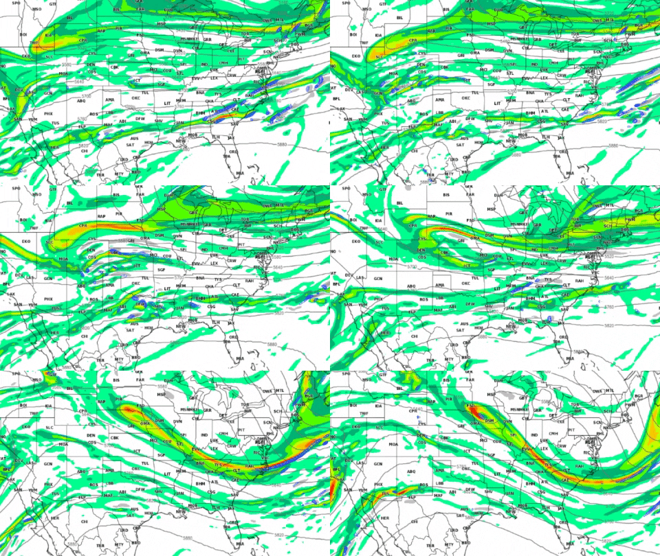
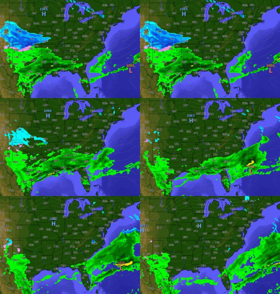
Already more moisture on the ICON,I’ll take this look from a warm biased model View attachment 34879
Can’t ever recall a coastal working out for us in the I-20 region of GA. We either get rain or get hosed on the transfer.Yes, that’s also such a waste of good opportunity down this way. We traditionally do well w overrunning if CAD sets up strong east of apps. If this were a classic CAD HP.....I think you’re spot on re models struggling w LP not being formed during event. I wonder what the chances are of this energy popping LP in gulf. It’s happened before......a ltl wave in the stream sliding by and suddenly we have LP forming. May not be the right setup now but I find these scenarios fascinating. Either way it seems it’s gonna pop a coastal off Carolina.
Yeah......the transfer can be a deal killer even when we do have a favorable LP track. Are you on north side of town (Atl)? If so, you’d stand a btr shot at some onset accum (if it’s even possible) than us further east.Can’t ever recall a coastal working out for us in the I-20 region of GA. We either get rain or get hosed on the transfer.
I’ve got a feeling this wi14 members now are getting north Georgia back in play. Slowly but surely. Reminds me of last weekend when we were only supposed to get a dusting the up to the night before the event and we got a little over 3 inches in Cherokee county Georgia.
like I said in a earlier post this looks like similar set up of what north Georgia went through a couple of weekends ago that went from a dusting to 3 inches It wouldn’t take much for this to turn into a north of I-20 special here in north Georgia. Moisture will not be a problem because every system we have had here in north Georgia has went over the amount of rain projected. I think this going to get better as we get closer and you can snow showing up now in north Georgia so temps are close and see that high pressure sliding into a good spot. Get the popcorn ready?No precip in the upstate. Coastal transfer kills it I think
That’s been my concern all along. We need that high pumping over NE to really feed it down east of apps I think. I’m out of town (beech mtn nc) and can’t see much on iPhone. Where’s that high modeling to set up currently??I’ve got a feeling this wi
like I said in a earlier post this looks like similar set up of what north Georgia went through a couple of weekends ago that went from a dusting to 3 inches It wouldn’t take much for this to turn into a north of I-20 special here in north Georgia. Moisture will not be a problem because every system we have had here in north Georgia has went over the amount of rain projected. I think this going to get better as we get closer and you can snow showing up now in north Georgia so temps are close and see that high pressure sliding into a good spot. Get the popcorn ready?
Would more of this be snow back in Charlotte?
That was a pretty shocking run. I don't think it's had more than trace amounts past the coastline in recent days, so that's a really huge shift at a pretty close range.I can't un-see the ICON, it has around .8 total qpf for this event imby and considering how warm it tends to be.... again let's see what the ukie and euro have to say.
About 2 miles south of 285/400 interchange. I’d be shocked if we see a flake. But we got in on the last system so anything else is a bonus this year IMHO.Yeah......the transfer can be a deal killer even when we do have a favorable LP track. Are you on north side of town (Atl)? If so, you’d stand a btr shot at some onset accum (if it’s even possible) than us further east.

Yep flow was back to flatter, still a decent hit but wrong directionNS energy on cmc not digging as much, probably won’t be impressive as the last run but will still be solid
I still wouldn’t be surprised that SER nudges it back in a bit. Coast looks good but piedmont may well cash in too before it’s over to some degree imho.And just like that, we have some convergence. Met MaulerView attachment 34891


This based on what exactly? Gut feelings? Wooly caterpillars? The magic conch?I don’t normally agree with Brad P. but I do for this one. This isn’t it for his viewing area of the Charlotte metro. Or even Boone NC for that matter.
WYFF noon forecaster has 47 and rain for Upstate on Th. 40% chance of precip.
They clearly are leaning on Globals vs NAM.
Sent from my iPhone using Tapatalk
That’s going to be pretty close to reality. I think there’s an outside chance we’re mostly dry though. That cold air behind the front is going to be pleasant ?WYFF noon forecaster has 47 and rain for Upstate on Th. 40% chance of precip.
They clearly are leaning on Globals vs NAM.
Sent from my iPhone using Tapatalk
They screwed that up up very badly. they were calling for a rain snow mix at most in the upstate.WYFF noon forecaster has 47 and rain for Upstate on Th. 40% chance of precip.
They clearly are leaning on Globals vs NAM.
Sent from my iPhone using Tapatalk
This based on what exactly? Gut feelings? Wooly caterpillars? The magic conch?
He’s been a metrologist for a long time. Based on his experience i would say
Sent from my iPhone using Tapatalk
