Also has the low stronger than 0Z, but we still need more precip to get anything out of thisEuro cooler for mid week system Still not much tho
-
Hello, please take a minute to check out our awesome content, contributed by the wonderful members of our community. We hope you'll add your own thoughts and opinions by making a free account!
You are using an out of date browser. It may not display this or other websites correctly.
You should upgrade or use an alternative browser.
You should upgrade or use an alternative browser.
Pattern January 2020 - Operation Thaw Alaska
- Thread starter KyloG
- Start date

And another look (cooler) for late week system. Lmao.
L
Logan Is An Idiot 01
Guest
Oh no.Euro actually was a little drier in the 700-850 layers versus the 0z around here. At face value it's a snow sounding
Attachments
Blue_Ridge_Escarpment
Member
The extended range warmth has just not verified this year.Oh no.
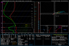
Not sure what got into the 12z cmc suite but there are a few members in the 996ish range near Wilmington Thursday morning while the closest gefs member was 1005. Eps should be interesting to see of there is any validity to the stronger father north idea
Which storm are we talking aboutNot sure what got into the 12z cmc suite but there are a few members in the 996ish range near Wilmington Thursday morning while the closest gefs member was 1005. Eps should be interesting to see of there is any validity to the stronger father north idea
These run to run changes are nuts. Every run showing different solutions.
Thursday 4 days from todayWhich storm are we talking about
EPS out?Not sure what got into the 12z cmc suite but there are a few members in the 996ish range near Wilmington Thursday morning while the closest gefs member was 1005. Eps should be interesting to see of there is any validity to the stronger father north idea
Probably but I don't have itEPS out?
Tomorrow looks very snow showery starting near 6z in the mtns (particularly Boone, NC). I wouldn’t discount a small chance of a mixed snow shower before lunch time in the western piedmont if we get to decouple tonight and moisture hits quick. Notice I left out most of the foothills, I believe a band forms just to the east. So maybe a small chance exists for Winston-Statesville areas or nearby. Otherwise, cold rain in the 30s.
Probably but I don't have it
No dice this run but the EPS is starting to juice the system up. Maybe this could turn out to be one of those surprise winter storms that creeps up on us within 5 days. We should probably keep an eye on this one.
12Z

06Z

Looks like a no go on th eps, precip stays south but I don't have great maps haven't looked at detailsProbably but I don't have it
My chase envelope includes the Catskills and while I would love to see a sub 970 occluding in to the LI Sound, doubts for next weekend starting early and only growing. Mid week kinda remind me of an event in 2014 or 2015, historians will need to keep me honest, forecasted as a chance of -RN and snow started in Greenville mid morning, snowed all day with about 3”. A low kicked offshore which kept the forcing and lift going through central and eastern Carolina. Cold was borderline and we went from nothing to Advisory pretty quick.
snowlover91
Member
NAM says hello.

Clem282340
Member
Would that be snow in the upstateNo dice this run but the EPS is starting to juice the system up. Maybe this could turn out to be one of those surprise winter storms that creeps up on us within 5 days. We should probably keep an eye on this one.
12Z
View attachment 32165
06Z
View attachment 32166
Looks like the NAM gets some of the ns energy in the system, helps juice it up and cold enough.... interestingNAM says hello.
View attachment 32170
NAM says hello.
I'll bite
Attachments
I’m not buying the long range NAM. I’ve noticed a clear bias with it being too wet. As much as I want it to be right..
NBAcentel
Member
I’m not buying the long range NAM. I’ve noticed a clear bias with it being too wet. As much as I want it to be right..
It’s actually been to dry recently
Clem282340
Member
Would that be snow in the upstate or is it to warmIt’s actually been to dry recently
Likely too warm but won’t know until the day before.Would that be snow in the upstate or is it to warm
Blue_Ridge_Escarpment
Member
Since the “upgrade” it’s been too dry.I’m not buying the long range NAM. I’ve noticed a clear bias with it being too wet. As much as I want it to be right..
NBAcentel
Member
NAM reminds me of a more north version of the March 12th, 2017 snow event, also the one from early March 2014, and those storms trended better in the 4 days leading up to it, just don’t think snow will be that far south 
... damn you 84 HOUR NAM .... DAMNNNNN YOUUUUUU FOR DRAGGING MY CHIPS IN
*i was going to put in whamby thread but seemed inappropriate with the other news sinking in*
*i was going to put in whamby thread but seemed inappropriate with the other news sinking in*
NBAcentel
Member
Nam is normally cold biased at the surface so we gotta take that into account, but this in my opinion is the best shot at seeing snow fall in NC outside the mountains so far this winter
NBAcentel
Member
What makes the run of the nam exciting was how temps were cooling during the event and 850s were cooling down a good bit along with the surface temps, NS energy phasing helps with that
Hour 81 (just west of CLT)
hour 84
 We still have a long way, but this one has me a bit excited that I least see a few snowflakes fall in this dumpster fire winter
Hour 81 (just west of CLT)
hour 84
We still have a long way, but this one has me a bit excited that I least see a few snowflakes fall in this dumpster fire winterCary_Snow95
Member

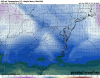
Here’s where the 18z ICON finished. It’s at 18z on the 31st so technically this is the correct thread to post this in 
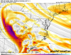
GFS definitely trending to send that thing negative tilt sooner..
If that were to verify, it looks like our area (RDU) would be good for wintery precip. At hour 84 surface temps would be ~34 with a dew point ~22. Surface winds would be from the due north, so no worries about warm air pushing in. 850 temps ~negative 4. At least this is something to finally track.... damn you 84 HOUR NAM .... DAMNNNNN YOUUUUUU FOR DRAGGING MY CHIPS IN
*i was going to put in whamby thread but seemed inappropriate with the other news sinking in*
Avalanche
Member
Chapel Hill putting the chips in.
Webberweather53
Meteorologist
GFS definitely trending to send that thing negative tilt sooner..View attachment 32187
This is great to see, w/ a stronger s/w we not only have a stronger system w/ more precip to work w/, but as the wave slows down, this allows for more separation between it and the vortex over Atlantic Canada, enticing a more intense storm to lift north in later runs. The increase in northern stream interaction also injects more cold air into this setup as we close in on verification. Hopefully this continues.
NBAcentel
Member
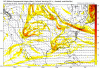
Obvious to see where this is going, soundings are noice just north of the precip sheild, supportive of snow, classic case of the north/northwest trend here with stronger energy/more digging 


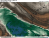
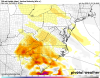
GFS much closer this run. Comparing the Nam and GFS, if we can see just a little more energy at H5 in the N/S (Circled region), this could put frozen precip in areas.
NAM

GFS


Much better than the last run
NAM
GFS
Much better than the last run
Last edited:
Could Columbia possibly get in the game? At Day 4Obvious to see where this is going, soundings are noice just north of the precip sheild, supportive of snow, classic case of the north/northwest trend here with stronger energy/more digging View attachment 32189View attachment 32190View attachment 32191
Also this system moves in over night .. we love to see itWhat makes the run of the nam exciting was how temps were cooling during the event and 850s were cooling down a good bit along with the surface temps, NS energy phasing helps with that
Hour 81 (just west of CLT) View attachment 32183
hour 84
View attachment 32184We still have a long way, but this one has me a bit excited that I least see a few snowflakes fall in this dumpster fire winter