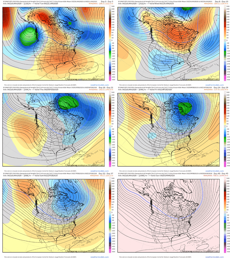
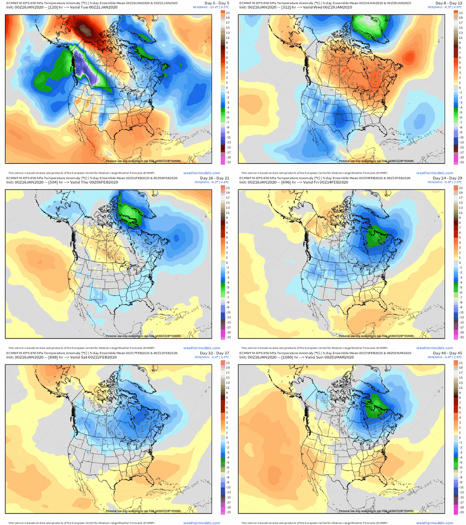
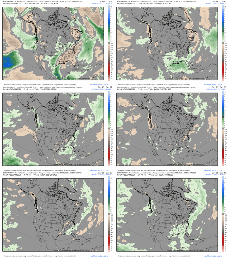
What do you have at 500mb you know I'm going to ask you this dailyEPS old day 10-15 versus the 5-10 from today's run. This is hard to believe the EPS bust this bad.
View attachment 31205
Sent from my SM-G975U using Tapatalk
What do you have at 500mb you know I'm going to ask you this dailyEPS old day 10-15 versus the 5-10 from today's run. This is hard to believe the EPS bust this bad.
View attachment 31205
I smell a huge CFS bust coming for Feb. Hopefully not though!
I don't remember any extreme changes like this ever taking place on the models. I wouldn't bite on any solution until there is actual consistency at this point.EPS old day 10-15 versus the 5-10 from today's run. This is hard to believe the EPS bust this bad.
View attachment 31205
CFS does this every winter. We will be in 5 or 6 in Feb and that’s almost a guarantee. CFS is awful and JB will use it when all other models should warm. Our only chance is Late Feb- March.
Sent from my iPhone using Tapatalk


In over 130 years of official records, Charlotte has never gone snowless for an entire winter, and only 6 or 7 times was there only a trace, so yes one would expect that even if we end up above normal on temps from now through the end of winter, history says Charlotte is more likely than not to have at least one snowfallThis may be me being an optimist, but I still am not ready to consider this winter over. We still good, solid 6 weeks of winter. I also have been living in Charlotte for 12 plus years and have never seen a winter with no snow. I think if and when we do get something, it won't show up until we get within the 5 day period. IMO, the LR forecasts from the models and the CPC haven't been that accurate this year. So, I have a hard taking them verbatim.


Why would you go with the colder GFS/GEFS and not the warmer Euro/EPS?I wouldn't go with the warm Euro or EPS. There is model agreement between today's 12z GEFS and EPS at 500mb. These maps are valid at the same day and time. Not sure why the EPS is warmer than the GEFS? and the GEFS is colder....but they both have the same setup at 500mb. GEFS is warmer than it's previous run, but it still has negative 2m temp anomalies in the southeast during and after the 27th. Hmmm, something isn't right. Sometimes I really do wonder if these models miscalculate numbers.

Sent from my SM-A102U using Tapatalk
Lot of zonal subtropical jet flow coming up. That's not gonna get the job done this winter, y'all.
That's exactly what I was thinking! This is crazy, no one would know which one to go with, but they're both identical at 500mb. There shouldn't be a huge difference with temps if they both have identical setups. Why would you go with the colder GFS/GEFS? Hasn't it been pretty consistent showing the cold? And the EPS has been flip flopping?Why would you go with the colder GFS/GEFS and not the warmer Euro/EPS?
crappy pacific+enhancement of the STJ from the AAM=poop sammichLot of zonal subtropical jet flow coming up. That's not gonna get the job done this winter, y'all.
crappy pacific+enhancement of the STJ from the AAM=poop sammich
That's exactly what I was thinking! This is crazy, no one would know which one to go with, but they're both identical at 500mb. There shouldn't be a huge difference with temps if they both have identical setups. Why would you go with the colder GFS/GEFS? Hasn't it been pretty consistent showing the cold? And the EPS has been flip flopping?
Sent from my SM-A102U using Tapatalk
crappy pacific+enhancement of the STJ from the AAM=poop sammich
Cutter city until either coast decides to offer some help too. Then you remove any semblance of a PV from the hudson region and actually go with a zonal flow there and the D10 eps is about as ugly as you can get.Big ol rain events


Pretty much every trend has been toward warming up, as opposed to cooling down. It probably makes more sense to lean in that direction, given the things we're seeing drive the pattern and the recent trends of the models. You were declaring winter over just the other day, when everything was looking cold. Now, you're leaning colder in the face of warmer trends. The warmer idea will likely turn out correct. But winter isn't over either.That's exactly what I was thinking! This is crazy, no one would know which one to go with, but they're both identical at 500mb. There shouldn't be a huge difference with temps if they both have identical setups. Why would you go with the colder GFS/GEFS? Hasn't it been pretty consistent showing the cold? And the EPS has been flip flopping?
Sent from my SM-A102U using Tapatalk
Yeah, I was declaring winter was over, but I wasn't serious about it. I was just frustrated that the patten went to crap as we went into this month. Sometimes after a long duration of a warmer pattern, the pattern can flip to a severe cold pattern. The 500mb pattern that we've been seeing during the last week doesn't look all that bad really. I'm still going with below normal temps, possibly much below during the last week.Pretty much every trend has been toward warming up, as opposed to cooling down. It probably makes more sense to lean in that direction, given the things we're seeing drive the pattern and the recent trends of the models. You were declaring winter over just the other day, when everything was looking cold. Now, you're leaning colder in the face of warmer trends. The warmer idea will likely turn out correct. But winter isn't over either.

Not with that look. Too much warm air. It's about as bad as the Euro was.Looking good at this stage on the 18z GFS. S/W sitting out to the west with the northern stream southward. We'll be watching this closely this weekend and all week next week. I bet there will be some good GEFS members this evening. View attachment 31219
Oh but you have. The ups and downs have been more extreme than usual. Just read the whamby. There’s really no need to even skim through the main thread tbhI'm glad I've been distracted from the increasingly grim medium-long range this week at AMS. Looks like I haven't missed anything.
I'm glad I've been distracted from the increasingly grim medium-long range this week at AMS. Looks like I haven't missed anything.
I don't have individual members but apparently some still do since the mean is showing some coastal snow@Ollie Williams or anyone else, would you please post the 12Z EPS members for the 1/21-2 coastal "threat"? I'm wondering if any members still have snow near the coast. The other day it was like 25-30% of them! TIA.

