2007-08 a good analog I think, just doesn't end well....
last part of Dec 2007, +AO/+NAO, Alaska in the freezer, warm east in general... 12/10/07 featured a high of 81!
View attachment 29473
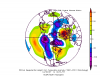
First half of January 2008. Featured more of the same, notice Scandinavia block building. This period featured monthly highs of 73 at RDU on 1/08-1/09. The first half of January featured cold shots but not super cold, warm overall. +EPO
View attachment 29472
Then came the mid month cool down. Our friend the GOA ridge. This period featured near normal temps for RDU a few below normal days.
View attachment 29474
But even in this period, we had a storm!
View attachment 29478
and another!
View attachment 29479
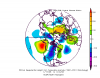
Last half of January....well this is awkward...that GOA ridge is still there. +AO/+NAO/-PNA
View attachment 29475
Fab Feb 2008?
First half of Feb...oh dear lord.
View attachment 29476
Last half. Colder, sure...but no blocking and a +NAO/+AO means near normal and some above normal days for RDU. No snow.
View attachment 29477
You don't want to see March.
I was actually just running with this and was hoping we'd get a stormy flip late, but we didn't. We did have two storms in January though so not all is lost even if we don't get a flip to cold and blocking...
edit: just ignore the attachments at the bottom of my post I don't know what I'm doing lol


 I am still watching mid next week for a slight chance.
.png")