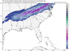
Some post frontal snow possible in parts of Tn, Ms, Al, NC.
Sent from my SM-G975U using Tapatalk
Sent from my SM-G975U using Tapatalk
It's a good setup to be honest for areas near Nashville. Have to be concerned about losing moisture in the dgz but good lift and enough lingering moisture to squeeze out a nice 1-3 event with maybe a 4 somewhere
Mid afternoon to midnight or so. Have to say I just looked at the icon and its basically a shut out so there's a little cause for concern here with maybe cold not making it in in timeWould this be a Tuesday daytime event for North Ms or an overnight Tuesday/Wednesday event?
Yeah, the 35” anafrontal snows for AL? When will we ever learn?"Remember last year" should be the battle cry here. Models are notorious for being way too fast with cold air.
Can you post the gefs members?Some of the gefs members has snow further south in MS/AL.


For you guys/gals in northern Al, the Euro actually looks better than the GFS.... keep hope aliveCan you post the gefs members?

Some of them is only 2 counties north from me

Yuck hope it trends better by tomorrow when do the new model runs arrive ?This was the 18z

Yes keep it going southWell the NAM keeps trying to inch that snow line down close into the NW corner of GA let's all hope that continues to maybe squeeze our some love for a few other southerners
It used to be. There has been a few times we been burned by it.Looks pretty good is this reliable though the model ?
Looks pretty good is this reliable though the model ?

We need this thing to tilt so neutrally that everybody gets snow. Probably won't happy though.0z gfs has central MS in the game now and almost central Al. Snow line creeping south. Gefs should good.
So close for places further south in MS/Al. I mean, couple of degrees?We need this thing to tilt so neutrally that everybody gets snow. Probably won't happy though.
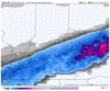
Don’t forget the tropical tidbits snow maps are honestly absolute TRASH. It’s the only part of the site I can’t stand. So that is very misleading. I really wish he would change them. I’ve seen those tropical tidbits snow maps in so many weather hyping posts across social media.
Pivotal Weather has Kuchera snow maps which are much much better. And much more realistic. We aren’t going to see widespread 5+ inches.
3km is even more conservative than this. That’s a Red flag and likely means this may even be overdone.
View attachment 27532