• Hello, please take a minute to check out our awesome content, contributed by the wonderful members of our community. We hope you'll add your own thoughts and opinions by making a free account!

Tropical Hurricane Dorian

How many other storms have hit the US three times? This one could hit Puerto Rico, Florida and go into the GOM for a third.

Puerto Rico is not a state and therefore not part of the United States of America so it's only two hits to the U.S. It is our territory, though. But it doesn't appear all that uncommon for a tropical system to make landfall on PR and then hit Florida and somewhere on the gulf coast states. If it tracks over PR for the length of the island, it may not recover much organization and strength before hitting FL. Hopefully this is the case.
 
Puerto Rico is not a state and therefore not part of the United States of America so it's only two hits to the U.S. It is our territory, though. But it doesn't appear all that uncommon for a tropical system to make landfall on PR and then hit Florida and somewhere on the gulf coast states. If it tracks over PR for the length of the island, it may not recover much organization and strength before hitting FL. Hopefully this is the case.
Oh ok. Dr. Masters said it could be a rare triple threat so didn’t know how many have done this to..Americans.
 
While the Euro landfalls in the same spot as 0z, afterwards it is a good chunk farther SW as it’s motion is much more westward due to the stronger ridge to its north which allows the second more stronger landfall in the GOM. The cutoff over the southern gulf is also stronger.

Really curious about the EPS.
12Z EPS has a considerable amount of members landfalling along the northern Florida, Georgia, and South Carolina coastlines. There are even a couple landfalling along the NC coastline. There is still considerable spread among the members though as several members also move accross Florida into the GOM.
 
While the Euro landfalls in the same spot as 0z, afterwards it is a good chunk farther SW as it’s motion is much more westward due to the stronger ridge to its north which allows the second more stronger landfall in the GOM. The cutoff over the southern gulf is also stronger.

Really curious about the EPS.

EPS 06Z is first 12Z is second

aal05_2019082706_eps_track_by_model_late.pngaal05_2019082712_eps_track_by_model_late.png
 
12Z EPS has a considerable amount of members landfalling along the northern Florida, Georgia, and South Carolina coastlines. There are even a couple landfalling along the NC coastline. There is still considerable spread among the members though as several members also move accross Florida into the GOM.

Definite jump North with the EPS since 00Z:


EPSTracks_2019-08-27_12Z_WN.png
 
Definite jump North with the EPS since 00Z:


View attachment 22105
Difficult to tell but it looks like, with the exception of a couple, most of the stronger members take it west.... which makes sense. But dang there is that one H that runs up I-95.... of course a couple down there that look like the ICON too so, long way to go no doubt
 
At this point I don’t think we’ll truly know the track until it gets closer to Florida. It’s all depending on the strength and timing of the ridge.
Along with about 6 other variables ... hang tight, keep an eye out, but no one needs to start calling a "landfall" or even strength at this point in time ...
 
Womp. May see more northward adjustments on upcoming model suites which puts the Carolinas & Georgia more in play. This also gives more time for Dorian to intensify and provides it a better chance to interact w/ the mid-latitude jet streak over the Carolinas around day 5 which would favor rapid intensification

 
Womp. May see more northward adjustments on upcoming model suites which puts the Carolinas & Georgia more in play.


One of the other 6 factors I alluded to above ... also include size, structure, sheer, steering currents, speed ...
Great point, Webb!
Phil
 
Instead of having a better idea of the track today, we have more uncertainty. I don't want to wish anything bad for anyone, but I am afraid if it doesn't hit south Florida and the more it stays north it will only get stronger over the open water for a landfall somewhere else.
 
Instead of having a better idea of the track today, we have more uncertainty. I don't want to wish anything bad for anyone, but I am afraid if it doesn't hit south Florida and the more it stays north it will only get stronger over the open water for a landfall somewhere else.

Definitely begins to put folks like us in NC closer to the line of fire if short-term trends continue going forward. Still a lot left to sort out.
 
Instead of having a better idea of the track today, we have more uncertainty. I don't want to wish anything bad for anyone, but I am afraid if it doesn't hit south Florida and the more it stays north it will only get stronger over the open water for a landfall somewhere else.
Still too early to rule out a east coast scraper and out to sea with only minimial coastal impacts given how the s/e coast is shaped.
 
203926_5day_cone_no_line_and_wind.png

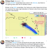
SUMMARY OF 500 PM AST...2100 UTC...INFORMATION
----------------------------------------------
LOCATION...15.3N 62.5W
ABOUT 80 MI...130 KM W OF DOMINICA
ABOUT 330 MI...530 KM SE OF PONCE PUERTO RICO
MAXIMUM SUSTAINED WINDS...50 MPH...85 KM/H
PRESENT MOVEMENT...WNW OR 300 DEGREES AT 13 MPH...20 KM/H
MINIMUM CENTRAL PRESSURE...1005 MB...29.68 INCHES


WATCHES AND WARNINGS
--------------------
CHANGES WITH THIS ADVISORY:

A Tropical Storm Warning has been issued for Vieques, Culebra, and
the U.S. Virgin Islands.

The Tropical Storm Watch has been discontinued for Saba and St.
Eustatius.

SUMMARY OF WATCHES AND WARNINGS IN EFFECT:

A Hurricane Watch is in effect for...
* Puerto Rico
* Dominican Republic from Isla Saona to Samana

A Tropical Storm Warning is in effect for...
* Puerto Rico
* Vieques
* Culebra
* U.S. Virgin Islands
* Dominican Republic from Isla Saona to Samana

A Tropical Storm Watch is in effect for...
* Dominican Republic from Isla Saona to Punta Palenque
* Dominican Republic from Samana to Puerto Plata

A Hurricane Watch means that hurricane conditions are possible
within the watch area. A watch is typically issued 48 hours
before the anticipated first occurrence of tropical-storm-force
winds, conditions that make outside preparations difficult or
dangerous.

A Tropical Storm Warning means that tropical storm conditions are
expected somewhere within the warning area within 36 hours.

A Tropical Storm Watch means that tropical storm conditions are
possible within the watch area, generally within 48 hours.

For storm information specific to your area in the United States,
including possible inland watches and warnings, please monitor
products issued by your local National Weather Service forecast
office. For storm information specific to your area outside of the
United States, please monitor products issued by your national
meteorological service.
 
I know you get asked this all the time but can you put this is laymen’s terms? Does it simply mean the guidance could track more easterly than it has been previously?
Edit - Stupid me found the explanation earlier. Sorry.
 

Attachments

  • 52F8AF1C-51F5-49B4-A2ED-70164D3E66FD.png
    52F8AF1C-51F5-49B4-A2ED-70164D3E66FD.png
    488.1 KB · Views: 14
EURO looked devastating for north Georgia anyone have rain total access
I wouldn't call 4 inches devastating like you had in your death "map" with 352385723890472389704mph winds and 3957290375 miles deep ocean of rain you created. Please keep it reasonable. Here's the map.
 

Attachments

  • us_model-en-087-0_modez_2019082712_240_508_220.png
    us_model-en-087-0_modez_2019082712_240_508_220.png
    312 KB · Views: 44
Womp. May see more northward adjustments on upcoming model suites which puts the Carolinas & Georgia more in play. This also gives more time for Dorian to intensify and provides it a better chance to interact w/ the mid-latitude jet streak over the Carolinas around day 5 which would favor rapid intensification


A westward moving, rapidly intensifying hurricane would be devastating to that area.
 
A westward moving, rapidly intensifying hurricane would be devastating to that area.
It's definitely going to be a big threat to Florida if it hits and crosses into the Gulf with that speed. I still think a track like Frances could happen. Seems like it would just get in line with where it went and hit Florida with similar intensity at worst case.
 
I wouldn't call 4 inches devastating like you had in your death "map" with 352385723890472389704mph winds and 3957290375 miles deep ocean of rain you created. Please keep it reasonable. Here's the map.
Thanks. Verification would likely triple that given that odd track, upslope and strength changes before landfall. Good thing it’s far away. Right now this storm is doing a lot of GOOD as Puerto Rico is under a moderate drought and US Virgin Islands need rain too!
 
It's definitely going to be a big threat to Florida if it hits and crosses into the Gulf with that speed. I still think a track like Frances could happen. Seems like it would just get in line with where it went and hit Florida with similar intensity at worst case.
Frances was horrible for one friend here ...
 
Back
Top