You couldn't have waited another hourSevere warned. The NWS obviously forgot about the sink air anom and also the fact that I just got back home. Sorry man.

Sent from my SM-G975U using Tapatalk
You couldn't have waited another hourSevere warned. The NWS obviously forgot about the sink air anom and also the fact that I just got back home. Sorry man.

I thought it was going to be later, honestly. But I was able to get ahead of the severe Greensboro storm. It was a mess! Worst driving conditions I've ever experienced. There was literally debris in the air for 5 minutes on 220.You couldn't have waited another hour
Sent from my SM-G975U using Tapatalk


Good lord radar looks good up your wayI thought it was going to be later, honestly. But I was able to get ahead of the severe Greensboro storm. It was a mess! Worst driving conditions I've ever experienced. There was literally debris in the air for 5 minutes on 220.
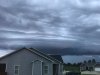
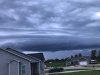
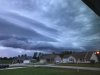
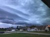
Here is a picture I took after I got ahead of it on 40 in Burlington.
View attachment 21838
And here is a picture of a car that ran through a roll of toilet paper that I was able to avoid. When you gotta go, you gotta go, I guess.
View attachment 21839
Clouds are moving in all directions! Its windy.Good lord radar looks good up your way
Sent from my SM-G975U using Tapatalk
When did you move to southern Wake?

Im sitting the over under at .12Looks like a marginal to slight risk of severe for most of the area today.
HrrrrRR shows most of the activity to the north and northeast.
View attachment 21860
3K NAMit brings the activity farther south:
View attachment 21861
View attachment 21862
Looks like a marginal to slight risk of severe for most of the area today.
HrrrrRR shows most of the activity to the north and northeast.
View attachment 21860
3K NAMit brings the activity farther south:
View attachment 21861
View attachment 21862

Going to foolishly go with short term persistence and take the over. Your location can serve as the official measuring station, since my guesstamator is only accurate to the nearest tenth of an inch.Im sitting the over under at .12
Sent from my SM-G975U using Tapatalk
Honestly wouldn't be surprised to see a slight expansion of the slight risk area to the south.They probably have the marginal more SE for more isolated pulse convection, altho some storms may show weak organization from increasing 0-3km shear, 3000 jkg of SBcape, lots of LLVL moisture with some drying around 700mb and 700-900 jkg of DCAPE is what’s making this threat today, idk tho profiles look soggy near CLT altho storms will likely try to find a way to get severe View attachment 21864
I expect it will expand south some and I'm going to set the over under up here at 1".... I'm on a rollHonestly wouldn't be surprised to see a slight expansion of the slight risk area to the south.
I expect it will expand south some and I'm going to set the over under up here at 1".... I'm on a roll
Sent from my SM-G950U using Tapatalk
The HRRR seems to be downplaying the storm coverage lately.
Sent from my iPhone using Tapatalk
It's humid as a myfro here. Full sun!Already full sun and no clouds on sight, could allow a few pockets of near 4500-5000 jkg of SBcape later
Doesn't look as if they it expanded it any in their morning update... Wake Co. still the ever present dividing lineHonestly wouldn't be surprised to see a slight expansion of the slight risk area to the south.
Should be a fun afternoon regardless. With the outflow moving south and the mid level flow SW to W we should see storms develop from N to S but cells generally move W to E which should lead to some nice rain totals. It also looks like somewhere either side of I40 may be a convergent axis for storms to fire ahead of the main showDoesn't look as if they it expanded it any in their morning update... Wake Co. still the ever present dividing line
Yeah I'm actually thinking you guys might be in that sweet spot today..... good luck and may the fro be with you.Should be a fun afternoon regardless. With the outflow moving south and the mid level flow SW to W we should see storms develop from N to S but cells generally move W to E which should lead to some nice rain totals. It also looks like somewhere either side of I40 may be a convergent axis for storms to fire ahead of the main show
Sent from my SM-G975U using Tapatalk
I'm actually thinking the 2 maximums are at the borders between 40/Va and 74/SC with the minimum in the middle. I wouldn't be at all surprised to get 0, the front is slowing just enough that we are really relying on the outflow as the main driver. If that doesn't kick things off around or shortly after dark the front timing will be terribly badYeah I'm actually thinking you guys might be in that sweet spot today..... good luck and may the fro be with you.
I'm actually thinking the 2 maximums are at the borders between 40/Va and 74/SC with the minimum in the middle. I wouldn't be at all surprised to get 0, the front is slowing just enough that we are really relying on the outflow as the main driver. If that doesn't kick things off around or shortly after dark the front timing will be terribly bad
Sent from my SM-G975U using Tapatalk

CAPE is up to 3000 jkg already here. We were only supposed to be around 1000 at this time.


We see what you did there....It's humid as a myfro here. Full sun!
It still dry as Howie MandelIt's humid as a myfro here. Full sun!
It still dry as Howie Mandel