JHS
Member
Had a 70% chance of storms in upstate SC today and there is very little on the radar over this area. I sure wish Barry was taking the track hurricane Francis took in 2004. Maybe it would finally rain around here.
Looking good!Had a 70% chance of storms in upstate SC today and there is very little on the radar over this area. I sure wish Barry was taking the track hurricane Francis took in 2004. Maybe it would finally rain around here.

Already up to 1.5 here now. It just keeps coming.
I'm going to be watching again tonight to see if another sort of band sets up anywhere nearby and does this again. It just came out of nowhere and exploded.I need to put up a range gauge, finally got in on the action last night as well, definitely a lot.


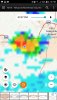
I win, decent amount of rain here View attachment 21068View attachment 21069

Don’t worry. Rain will pick back up when I pull back into the 864While Mack loses ?


Don't count your blessings yet, Thursday through Sunday of next week could all be near 100. Couple of ways this can go #1 we see a lingering low/mid level trough from Barry hang on if a weakness on the east side of the developing central us ridge can form over the area increasing rain chances and keeping us more in the mid 90s. 2nd we see Barry quickly pushed out to sea and the ridge builds in far enough east warm 850s are affected in on the NW flow and we get a bunch of days near 100 with dews mixing into the 50s and 60s.No 100 degree days in the forecast, but plenty of mid 90s. I guess that is the norm now. Instead of two or three days of triple digits we just get a whole month of mid 90s heat.
Weatherflow updated since it is still "learning" total was 2.68.1.77
Sent from my SM-G975U using Tapatalk
Don't count your blessings yet, Thursday through Sunday of next week could all be near 100. Couple of ways this can go #1 we see a lingering low/mid level trough from Barry hang on if a weakness on the east side of the developing central us ridge can form over the area increasing rain chances and keeping us more in the mid 90s. 2nd we see Barry quickly pushed out to sea and the ridge builds in far enough east warm 850s are affected in on the NW flow and we get a bunch of days near 100 with dews mixing into the 50s and 60s.
Sent from my SM-G975U using Tapatalk

Storms are all around me.... just a matter of time since I just finished cutting the grass.
.... nevermind
Sent from my iPhone using Tapatalk
Fell asleep and then woke up to a deluge outside with some rumbles of thunder.
We saw 3 observations of 89*F, so will have to wait until later to see if there was an intra-hour 90*F.

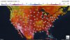
I feel like this has been the same D10+ model image since 5/1 and every time we have ended up with a trough in the NW and big heights over the SE. It would certainly be nice to get into a long period of western ridge east trough to end the month
Sent from my SM-G975U using Tapatalk
Welcome to winter in the SE!I feel like this has been the same D10+ model image since 5/1 and every time we have ended up with a trough in the NW and big heights over the SE. It would certainly be nice to get into a long period of western ridge east trough to end the month
Sent from my SM-G975U using Tapatalk


12z Euro is crazy hot Saturday and Sunday. Really getting on board with 100+ both days next weekend. Interestingly enough the heat may be centered more toward the mid Atlantic where areas could push 105
Sent from my SM-G975U using Tapatalk
Just had a couple of gravity waves go thru and a cool wind whipped up while I was picking blue berries, and that was the best feeling 82 I've experienced in a whileThe good news is that the Euro was 8-10 degrees too hot on several runs with the late May heatwave. I mean it had way beyond stupid heat values of absurdly hot at 18Z/2 PM of 108-111 in parts of S GA and N FL.! The culprit apparently was too low dewpoints making it heat up faster than reality. OTOH, the old GFS had higher dewpoints and consequently lower 18Z temps. Is that happening this time? I don't know.
") It's the odd things on a hot summer's day that makes it bearable sometimes.
It's the odd things on a hot summer's day that makes it bearable sometimes.Yeah I'm wondering if the Euro may be too hot again at 2m. The one thing that makes me think we might inch closer to 100 is the 850mb temps around 25c which seems to be a benchmark around here too push or exceed 100.The good news is that the Euro was 8-10 degrees too hot on several runs with the late May heatwave. I mean it had way beyond stupid heat values of absurdly hot at 18Z/2 PM of 108-111 in parts of S GA and N FL.! The culprit apparently was too low dewpoints making it heat up faster than reality. OTOH, the old GFS had higher dewpoints and consequently lower 18Z temps. Is that happening this time? I don't know.
Just one in 365 would be a miracle of sorts ...Ill take a 33 degree rain day over this crap any day of the week
Last couple of days have been miserable and only going downhill from here.... rough stretch coming up. Man I hope this is it for the summer, the extreme stuff anywaysGoing to be a 7+ day stretch of 95+ coming up. Think saturday or Sunday goes 100-102 at rdu
Sent from my SM-G975U using Tapatalk
Going to be a 7+ day stretch of 95+ coming up. Think saturday or Sunday goes 100-102 at rdu
Sent from my SM-G975U using Tapatalk