Snowflowxxl
Member
Indicates cellular movement imo

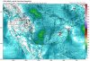
Euro has some ridiculous CAPE values in south Alabama on Sunday.
That was a nasty day..The Euro is absolutely nasty across AL and GA. Moisture continues to increase with dew points 65-68 across the area and any less convection and that 2000+ cape gets north.
I'm gonna throw 3/15/2008 as my analog at this point.


I definitely want to forget that day. It was horrible and probably one of the few times I've seen quarter sized hail actually fall in addition to having 2 tornado warnings in an hour.
I got near golf ball size hail that day, grandpa that passed away from cancer replaced almost all parts of his roof after those storms


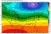
ICON looks quite menacing and has some sharp temp differentials in NC as well. This is definitely looking like a severe threat if things hold.
View attachment 16830
Probably some high helicity along that wedge front

Birmingham AFD
View attachment 16831
Wish we could get him back with us.Matt about to bring the wood.
Im interested do you have this map for South Carolina Webb?I personally wouldn't mind a little teeny wedge right along the blue ridge escarpment to enhance local baroclinicity and horizontal shear in the central-western piedmont. This is actually largely why there's a secondary local max in tornado track density over Charlotte and Winston-Salem w/ the main corridor being my old stomping grounds in Fayetteville and areas along/just east of I-95.
View attachment 16797
Im interested do you have this map for South Carolina Webb?
Probably some high helicity along that wedge front
ICON still looks nasty, NAM was also looked like it was setting up some juicy temps/dp's at the end of the run.

Model trends are now giving clearer indications of a potential
severe weather event on Sunday. With the upper-level vortex over
southern Canada becoming less suppressive, a powerful channeled
upper-level may take on a more cyclonic shape by Sunday afternoon
as it races eastward across Texas toward the Lower Mississippi
Valley. Operational and ensemble model guidance are strongly
supportive of cyclogenesis near the Ark-La-Tex on Sunday morning,
causing a warm front to move northward with mid to upper 60s
dewpoints spreading inland through the late morning hours. This
will occur beneath relatively low 500mb to 300mb heights and
temperatures, resulting in the potential for an expansive area of
SBCAPE of 1000-2500 J/kg. However, the northward extent of the
warm sector remains in question and may not move inland as
efficiently as suggested by current model guidance. An upstream
EML would help the warm front advance northward, but there is
little to no indication of an EML at this time. Currently, it
appears that an effective warm front could become hung up near the
I-20 corridor. A deepening surface low should track toward Middle
Tennessee and continue moving northeastward Sunday afternoon with
strong height and pressure falls occurring across Alabama. If a
quality warm sector can become established, wind profiles could
become supportive of severe storms and tornadoes as suggested by
the ECMWF. Development could occur anytime from the late morning
through the afternoon hours as the nose of a diffluent 300mb jet
overspreads the region. The ECMWF has been leading the way with
this scenario for several runs and continues to explicitly depict
multiple long-track supercells impacting Alabama as storms become
organized just ahead of the cold front during the afternoon. A
tornado threat could become maximized near any boundaries from
morning convection or near an effective warm front. This is a very
bullish idea from the ECMWF and will need to be confirmed by
other models before sounding the alarms. Forecast confidence is
low regarding critical details, but a threat for severe storms and
tornadoes will be added to the HWO


.gif")
.gif")


