-
Hello, please take a minute to check out our awesome content, contributed by the wonderful members of our community. We hope you'll add your own thoughts and opinions by making a free account!
You are using an out of date browser. It may not display this or other websites correctly.
You should upgrade or use an alternative browser.
You should upgrade or use an alternative browser.
packfan98
Moderator
Heck of a run for the NE. This should give us a good snowpack to funnel the cold on down:Fans of dry cold will like the 12Z Euro, which is much colder than the 0Z and threatens a freeze for ATL as early as 2/27.

Webberweather53
Meteorologist
Beautiful -EPO is showing up on most guidance beginning next week esp this afternoon's ECMWF run, really can't be too upset with a pattern like this.
.png")
A feature like this would also provide some confluence for locking in a high, although I do see what looks to be our friend, the Lakes Low, showing up....but it's not always a bad thing:Beautiful -EPO is showing up on most guidance beginning next week esp this afternoon's ECMWF run, really can't be too upset with a pattern like this.
View attachment 16004
.jpg")
Webberweather53
Meteorologist
A feature like this would also provide some confluence for locking in a high, although I do see what looks to be our friend, the Lakes Low, showing up....but it's not always a bad thing:
View attachment 16006
Right because there are cases (like the awesome Jan 20 2009 storm) where having a Lakes low doesn't mean it can't be cold enough to snow, it's also important to know the evolutionary stage of said low because a very strong, low undergoing occlusion will actually aid in cold air advection well to its southeast where a warm conveyor belt is typically located
accu35
Member
For the first time in a while, I'm feeling good about first week in March. At some point in winter, a legitimate storm will happen for the deep southeast and I believe with current strong signals it could happen around March 2/3/4 time frame.
Many folks will probably not like the 12Z EPS for Mar 1-3 since those days are warmer than the prior run though 3/4 is colder.
Edit: The SE is still on the edge of the battle zone between cold to our NW and warmth near us and to our SE thus meaning a wet setup with a Gulf low or two likely in the pic. But we need the cold to push more and make it cold enough for wintry for more than mainly just TN and WNC or else it is liable to mean mainly just lots of cold rain for places like ATL, Birm, and GSP.
Edit: The SE is still on the edge of the battle zone between cold to our NW and warmth near us and to our SE thus meaning a wet setup with a Gulf low or two likely in the pic. But we need the cold to push more and make it cold enough for wintry for more than mainly just TN and WNC or else it is liable to mean mainly just lots of cold rain for places like ATL, Birm, and GSP.
Last edited:
1 thing I can count on is with all the models and there ensembles showing different looks each run is that a pattern change is coming.
pcbjr
Member
Pardon the brevity ... on a break ...
This is a positive sign (SER gets shunted) ...


This looks OK ... not much red except in someone's back yard ...


short term though, this is a "no like" ...

PNA and NAO are both also disheartening for a while ...
We'll see; sorry for the lack of analysis, but the bell is ringing again in 5 ...
This is a positive sign (SER gets shunted) ...
This looks OK ... not much red except in someone's back yard ...
short term though, this is a "no like" ...
PNA and NAO are both also disheartening for a while ...
We'll see; sorry for the lack of analysis, but the bell is ringing again in 5 ...
Last edited:
ForsythSnow
Moderator
Only if they show up in the ensembles or several days of runs. I'll only believe it if it's falling.You know what’s not disheartening... consistent fantasy storms to drool over
B
Brick Tamland
Guest
You know what’s not disheartening... consistent fantasy storms to drool over
GFS is all about that March 5th storm today.
B
Brick Tamland
Guest
Only if they show up in the ensembles or several days of runs. I'll only believe it if it's falling.
Needs to show up in both for several days of runs and inside 5 days. Don't forget how the ensembles were showing fantasy storms, too.
NBAcentel
Member
This is by hour 240... , nice -EPO, weak -NAO/-AO, weak +PNA, pv lobe displaced but I would want it little more further south, still decent looking pattern here, models will probably begin to show some type of storm around this time soon 
Webberweather53
Meteorologist
It's going to snow in Las Vegas for the 3rd time in about 2 weeks whose snowfall climo is significantly worse than both Atlanta, GA & Columbia, SC
We suck.
We suck.
Euro has just about every block you need ... and only day 8 ... seeming how the euro is consistent and has seen the warm pattern so well .. I’m assuming it knows the cold pattern too... I bet it shows a storm at the end of the run .... feast your eyes... +PNA/ -NAO/ -AO/ -EPO .... this is just screaming east coast fun
Attachments

NBAcentel
Member
Fwiw, feast your eyes on this 0Z Euro 240 hour map, folks: yes, that's a 1055 mb high!
View attachment 16050
I may be wrong and probably will, but I’m getting a feeling there will probably be a winter storm somewhere in the southeast around this timeframe, lol I sound dumb
ATLwxfan
Member
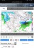
Fantasy storm went poof. Lock the thread. 00z GFS was hideous beginning to end. Bad look here. Hopefully no ensemble support..
View attachment 16045
GFS verification scores are so terrible we should stop talking about it. Euro is the established leader. It shows promise for once.
Sent from my iPhone using Tapatalk
packfan98
Moderator
Looks to be a pretty strong storm signal for a SE storm for the first week in March on the GEFS:

0z Eps takes shape and starts looking Good/ or better starting this Tuesday onward: We should all see a 24 hr torch Sun or Mon, not sure if it will be a dry one. Heres Tuesday from the EPS

Last edited:
Yep with a few big dogs sprinkled in for good measure.... EPS doesn't look bad just not that storm signal like the gefs (yet)Looks to be a pretty strong storm signal for a SE storm for the first week in March on the GEFS:
View attachment 16051

Just one ens suite of course but I think I'd rather all the members show something but as it is looks like an all or nothing on the 0z gefs I posted above.
Yet another 10 day+ storm. Still, good to see a storm signal. Maybe we can finally reel one in. A few of those are major hitsYep with a few big dogs sprinkled in for good measure.... EPS doesn't look bad just not that storm signal like the gefs (yet)
Storm5
Member
Yep with a few big dogs sprinkled in for good measure.... EPS doesn't look bad just not that storm signal like the gefs (yet)
The gefs has been showing a storm signal for the last two months . It needs to be fixed , it clearly has a cold snowy bias
With that said , there are a few members in there that I’d loan the wife out for
Sent from my iPhone using Tapatalk
ATLwxfan
Member
The gefs has been showing a storm signal for the last two months . It needs to be fixed , it clearly has a cold snowy bias
With that said , there are a few members in there that I’d loan the wife out for
Sent from my iPhone using Tapatalk
Stick to sodomizing pigs (no not really). EPS also has some solid members for NGa. I think it’s huge that both ensembles are sniffing it out. Truthfully the GEFS may sniff out legit threats but it can’t navigate teleconnections.
Sent from my iPhone using Tapatalk
Fountainguy97
Member
During pattern watching I normally just lurk, but here are my two cents.
First step: GET A +PNA
If we cant manage that then forget any chances of snow into March.

The good news is that we have a solid signal of atleast a weak +PNA event.
The flip from -pna to + is only 5-7 days out so this isn't in la la land.
here is the EURO progression from -PNA to +PNA.

For now we want to MAKE SURE that this +PNA is actually going to happen. I would lock it in before even considering a winter storm for us.
The good news is the +PNA signal on models is fairly strong. EPS is trending stronger as well as the EURO.
For me I want to verify this pattern change before looking at storms. We all know how crazy models get during big time flips like this.
I'm not extremely pumped up about this flip but hey its better than no chance at all.
First step: GET A +PNA
If we cant manage that then forget any chances of snow into March.
The good news is that we have a solid signal of atleast a weak +PNA event.
The flip from -pna to + is only 5-7 days out so this isn't in la la land.
here is the EURO progression from -PNA to +PNA.
For now we want to MAKE SURE that this +PNA is actually going to happen. I would lock it in before even considering a winter storm for us.
The good news is the +PNA signal on models is fairly strong. EPS is trending stronger as well as the EURO.
For me I want to verify this pattern change before looking at storms. We all know how crazy models get during big time flips like this.
I'm not extremely pumped up about this flip but hey its better than no chance at all.
B
Brick Tamland
Guest
Yep with a few big dogs sprinkled in for good measure.... EPS doesn't look bad just not that storm signal like the gefs (yet)
Wow, great mean and five big dogs in there for NC. Looks like it's mostly the big dogs or nothing, though.
GFS and GEFS look good. And seems the Euro is trying to get there.
The GFS and Euro are in fairly good alignment for once about the MJO. Neither one now ties it up in P8 and both propagate it into P1-3. We're seeing a good response in the atmosphere also.


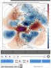
Here is the 240 hr EPS and GEFS mean H5. You can see that both are in very good agreement with the overall pattern. Nice Omega block out west. Someone correct me if I'm wrong here, but I think that type of configuration is a fairly stable configuration. So hopefully, this one will last at least a little while.
You can see the big AK block with troughing in the central and eastern US and the STJ undercutting. Still going to be quite active, with plenty of rain. But now, we have growing confidence in what appears to be one last legitimate window for a big winter storm in the SE.


The daily SOI is ~ -30. So, we're still seeing big drops there. The typhoon is also still a question mark. Some of the EPS members recurve it (more do not). All of the GEFS do. The GEFS progs for the AO and NAO are generally positive longer term and the PNA varies + to - to +. The EPO looks strongly negative.
I still think the time frame just beyond D10 holds the best window for a storm. I don't think there's a lot of accuracy with with predictions beyond 7 days, really, but we have pretty good agreement, at least right now, about the overall evolution of the pattern into one that could support a real storm. By D10, we should be there. Fingers crossed....
Here is the 240 hr EPS and GEFS mean H5. You can see that both are in very good agreement with the overall pattern. Nice Omega block out west. Someone correct me if I'm wrong here, but I think that type of configuration is a fairly stable configuration. So hopefully, this one will last at least a little while.
You can see the big AK block with troughing in the central and eastern US and the STJ undercutting. Still going to be quite active, with plenty of rain. But now, we have growing confidence in what appears to be one last legitimate window for a big winter storm in the SE.
The daily SOI is ~ -30. So, we're still seeing big drops there. The typhoon is also still a question mark. Some of the EPS members recurve it (more do not). All of the GEFS do. The GEFS progs for the AO and NAO are generally positive longer term and the PNA varies + to - to +. The EPO looks strongly negative.
I still think the time frame just beyond D10 holds the best window for a storm. I don't think there's a lot of accuracy with with predictions beyond 7 days, really, but we have pretty good agreement, at least right now, about the overall evolution of the pattern into one that could support a real storm. By D10, we should be there. Fingers crossed....
Fountainguy97
Member
The GFS and Euro are in fairly good alignment for once about the MJO. Neither one now ties it up in P8 and both propagate it into P1-3. We're seeing a good response in the atmosphere also.
View attachment 16055
View attachment 16056
Here is the 240 hr EPS and GEFS mean H5. You can see that both are in very good agreement with the overall pattern. Nice Omega block out west. Someone correct me if I'm wrong here, but I think that type of configuration is a fairly stable configuration. So hopefully, this one will last at least a little while.
You can see the big AK block with troughing in the central and eastern US and the STJ undercutting. Still going to be quite active, with plenty of rain. But now, we have growing confidence in what appears to be one last legitimate window for a big winter storm in the SE.
View attachment 16058
View attachment 16059
The daily SOI is ~ -30. So, we're still seeing big drops there. The typhoon is also still a question mark. Some of the EPS members recurve it (more do not). All of the GEFS do. The GEFS progs for the AO and NAO are generally positive longer term and the PNA varies + to - to +. The EPO looks strongly negative.
I still think the time frame just beyond D10 holds the best window for a storm. I don't think there's a lot of accuracy with with predictions beyond 7 days, really, but we have pretty good agreement, at least right now, about the overall evolution of the pattern into one that could support a real storm. By D10, we should be there. Fingers crossed....
Great post.
IMO this really is a great time to get a winter pattern. It takes perfection like always but the increased sun angle can actually really juice up some of these storms on top of the fact we have some spring time forcing in the mix as well.
A lot of our big storms have happened late in the season. The problem is the cold source. We will have plenty of rain and moisture.
Too me this +PNA ridge that will form won’t be very long lasting but even 7-10 days of decent west coast ridge and east coast trough can give us 2-3 legit storms to consider.
For now we just have to wait it out. Models are focusing in on the beginning of our pattern change but the meat of the pattern is still off in la la land.
Honestly this is not a bad look at all. Maybe one of the most promising patterns since the early December setup for the southeast. Just have to get it to verify.
How about how crappy the GFS based MJO was..... lmao remember when it was trying to drive it off the scale in P7? What a joke
Great points. And as far as “stable” goes I believe a -EPO has as much staying power as. +EPO. AK ridge is a must if we want resultsThe GFS and Euro are in fairly good alignment for once about the MJO. Neither one now ties it up in P8 and both propagate it into P1-3. We're seeing a good response in the atmosphere also.
View attachment 16055
View attachment 16056
Here is the 240 hr EPS and GEFS mean H5. You can see that both are in very good agreement with the overall pattern. Nice Omega block out west. Someone correct me if I'm wrong here, but I think that type of configuration is a fairly stable configuration. So hopefully, this one will last at least a little while.
You can see the big AK block with troughing in the central and eastern US and the STJ undercutting. Still going to be quite active, with plenty of rain. But now, we have growing confidence in what appears to be one last legitimate window for a big winter storm in the SE.
View attachment 16058
View attachment 16059
The daily SOI is ~ -30. So, we're still seeing big drops there. The typhoon is also still a question mark. Some of the EPS members recurve it (more do not). All of the GEFS do. The GEFS progs for the AO and NAO are generally positive longer term and the PNA varies + to - to +. The EPO looks strongly negative.
I still think the time frame just beyond D10 holds the best window for a storm. I don't think there's a lot of accuracy with with predictions beyond 7 days, really, but we have pretty good agreement, at least right now, about the overall evolution of the pattern into one that could support a real storm. By D10, we should be there. Fingers crossed....
Holy Moses, 1060+ mb high SW Canada 12Z GFS moving south hour 222. But will SE get much of this or will it mostly slide to our north? Will know soon. May stay north. Tough to get cold down into the SE these days.
Just to reiterate GFS past day 6 or so is basically useless. 30 degree+ difference 

FV also has a high dropping down, 1043Holy Moses, 1060+ mb high SW Canada 12Z GFS moving south hour 222. But will SE get much of this or will it mostly slide to our north? Will know soon. May stay north. Tough to get cold down into the SE these days.
Here is my take based on observations. Last nights event and a previous small event has turned much snowier for western NC compared to previous icing systems. I believe the ice pattern has finally eased up to a snowier pattern into March. But this new pattern will battle some moisture issues during times of CAD. No change to my late winter outlook. I expect no big dogs over 6” but a more pronounced snow vs rain setup could put more areas in play instead of the usual ice cad only crap.
accu35
Member
Just a 1055 H coming down, nothin major

ATLwxfan
Member
Just a 1055 H coming down, nothin major
Coming down and skirting east, unfortunately. Though enough of a glancing blow to make the rain especially chilly.
Sent from my iPhone using Tapatalk
Looking at the ensembles I could see the Raleigh/Greensboro camp being included with some snow mix for March. With an increasingly more snow potential further north and west. I don’t however like the Charlotte to Atlanta corridor in this new pattern...I think it’s going to favor the northern corridor so to speak but with some eastward potential.
Coming down and skirting east, unfortunately.
Sent from my iPhone using Tapatalk
A 1060 high and KATL still can't even go below 32!