I just don't think this has large bust potential on the upper end at least not yet anyways, I will be shocked if anyone east of the mountains tops out over 2-3". The selling point for me to go conservatively on the snowfall totals east of the mountains is the fact we'll have to erode a very stout +5-7C warm nose. Even w/ robust low-level cold air advection and melting hydrometeors cooling the low-levels on the backside of the low, once the CAA sets in and the mid-level warm nose begins to erode, turbulent mixing will offset these cooling processes as the entire low-mid level layer becomes effectively homogenized, keeping the low levels from getting too much colder than they would otherwise and the propensity for sleet mixing in (which will have ratios of ~2-3:1) will further hamper any snow accumulation.
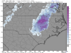
Just accounting for melting, the snow accumulations are heavily dampened w/ only a few isolated spots getting 1-2". This map doesn't consider mixing w/ sleet (but does consider melting & compaction) and if you do so, these accumulations shown below will be cut by at least half or two-thirds.
View attachment 4440
View attachment 4441

.png")


