Round Oak Weather
Member
JB got the hurricane and the cold shot coming up and he’s got a lot of back up to make his forecast for the winter a very real possibility. Maybe to intense but it may be close!!!


UK Seasonal. I don't recall a UK seasonal run being this BN for winter months. Will go check 13/14 and 14/15.
So, that DJF forecast is essentially 1-2 F colder than normal, which is other than that area south of S America the coldest area on the entire globe! Definitely encouraging but I’d like to know their track record. Does anyone have a link to past years’ DJF forecasts?
Can't show it yet but both the 51 member ensemble mean EURO and CPC latest run show Oct/Nov/Dec as being well above normal for the SE
They both are NOAA products with the CFS-V2 being the monthly prediction (which runs every day) and the CPC seasonal model which is a seasonal prediction model which runs once a month around mid month. It uses a percentage bases for the upcoming season and you often see it depicted as an above, below, or equal chance of colder or warmer than normal. I show it here:I have the latest Euro monthlies and Nov is AN for SE. Dec-Feb are solidly BN.
What is CPC? CFSv2?


Cohen not enthused about the snow cover extent. Seems like past few winters we have had expansive snow cover where he wants and haven't seen the blocking. Hopefully we can get some blocking this winter even with low SAI/SCE.
 Don’t know if y’all have seen Accuweathers forecast yet
As accurate as there 60 days forecast.View attachment 6980 Don’t know if y’all have seen Accuweathers forecast yet
Didn’t BHAM and West GA score a few times last year, east ATL- SC people need some this year, I’m getting tired of .1 to 1in a year when I can drive 45min and see 4-6. Hopefully it’s our turn this year.Accuweather is VERY NE/Mid-Atl biased....I don't take their forecasts for the SE very seriously. Weather.com at least is HQ'd in Atlanta so they put a little more time and effort into our neck of the woods.
That being said, I have a feeling the lower MS valley is going to have a great winter with troughs centered on MS/ARK. Cities like Jackson/Birmingham/Memphis could really score.
Some places in Ga had the snowstorm of a lifetime last December....We’ve already had the hurricane of a lifetime. What about the snowstorm of a lifetime? Dream big or go home
We didn’t get it here just some cold rainSome places in Ga had the snowstorm of a lifetime last December....
12” here, no power for over a daySome places in Ga had the snowstorm of a lifetime last December....

Southern slider is our best bet. Don’t hold your breathWe just need a board wide snowstorm.
I agree. Based on what I see with the factors already mentioned, including possible weak El Nino, low sunspots, etc., I feel that this may be a great winter for my neck of the woods. Even with last winter, which was overall slightly warmer than average, we saw two snow events. February basically shut down winter for us across the SE. My point is that even if an average winter were forecast, I'd be more interested in the magnitude of cold periods when they come than the overall trend of temps and precip for the 3 month winter as a whole.Accuweather is VERY NE/Mid-Atl biased....I don't take their forecasts for the SE very seriously. Weather.com at least is HQ'd in Atlanta so they put a little more time and effort into our neck of the woods.
That being said, I have a feeling the lower MS valley is going to have a great winter with troughs centered on MS/ARK. Cities like Jackson/Birmingham/Memphis could really score.
Some places in Ga had the snowstorm of a lifetime last December....
Yes it is and last year was not one but 3 snows for me. If we can get our El NINO to kick in and our low riders than we good.Southern slider is our best bet. Don’t hold your breath
We just need a board wide snowstorm.
 Last year was horrendous to watch
I would think that highs in the 40s in Dallas in Mid October is nearly unheard of.yes and include us this time
Meanwhile I got to Chicago this afternoon and wow... these temps are like winter in October
The irony is Dallas will be close to this on Monday/Tuesday and worse, with rain and wind...
I would think that highs in the 40s in Dallas in Mid October is nearly unheard of.
It's going to be very hard to top last winter for many areas of the south. You just don't get that kind of snowstorm very often. Maybe once every 30 years.

The Nuns drilled it into the noggin years ago ... Hit the nail on the head, don't batter the board ... You sunk that nail squarely ...Great.... Joe Bosardi says the word "Antilog" gulp!
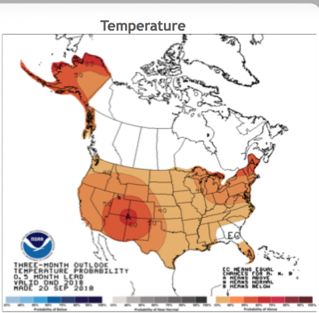
If I'm looking at the map right, it looks like this winter will be hot in Canada and the northern US and cold in the south which makes me wonder where all the cool air is coming from if the areas further North are so warm.Take a big gulp of 90 proof, burp, take another and then proceed to read ...
~~~~~~~~~~~~~~~~
View attachment 6996
Relative to normal, if you trust the map ... but God works in mysterious ways, I suppose ...If I'm looking at the map right, it looks like this winter will be hot in Canada and the northern US and cold in the south which makes me wonder where all the cool air is coming from if the areas further North are so warm.
... (maybe we were all good children this year ... although Charlie's pig gives me significant pause on that thought ...)"hot" in Canada is still plenty cold for snow hereIf I'm looking at the map right, it looks like this winter will be hot in Canada and the northern US and cold in the south which makes me wonder where all the cool air is coming from if the areas further North are so warm.
If I'm looking at the map right, it looks like this winter will be hot in Canada and the northern US and cold in the south which makes me wonder where all the cool air is coming from if the areas further North are so warm.