Jon
Member
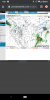
NOAA uses arbitrarily defined thresholds for ENSO criteria and only uses ERSSTv5 for their analyses (my ENS ONI is a lot better). There's definitely a pretty clear NINO lean to this winter that's not normally present even in "official" events & I've stated my case on here many times and on twitter and I certainly don't feel like repeating myself again.
You don't get extreme tropical +AAM spikes like this when ENSO is "neutral" (which it's clearly not this year), in fact the tropical +AAM was so strong that it was westerly in the means for the first time ever in the satellite era.
Nor do you see incessant dateline westerly wind bursts for several months in a row when ENSO is "neutral", the base state has to be advanced enough towards El Nino to do this, which it is this year.
View attachment 31685
As for a previous post where it was claimed 1939-40, 1951-52 2008-09, & 1979-80 were "neutral" ENSO winters
1951-52 was a weak-moderate NINO winter, 2008-09 was a La Nina winter, 1939-40 was a late blooming moderate El Nino, 1979-80 by some metrics was also an El Nino.
This is taken from my webpage & research on the Oceanic Nino Index which uses twenty six SST reconstructions and reanalysis datasets. The values derived here are more robust & meaningful than NOAA's which uses only ERRSTv5 (w/ no quality control of the data):
https://www.webberweather.com/ensemble-oceanic-nino-index.html
It's in really close agreement w/ NOAA's index over the latter portions of the record, only differences emerging from the fact that I use a lot more datasets and filter out bad/potentially spurious data.
View attachment 31682
View attachment 31686
View attachment 31684
View attachment 31683
I asked nicely, if you don't feel like repeating yourself then don't do so. Thanks anyway.