Lol yes, that’s devastating. Half a foot of snow.So frustrating. I'm where the little yellow dot is. I know theres no way the model nails that gradient that closely but its frustrating being that close to it.
-
Hello, please take a minute to check out our awesome content, contributed by the wonderful members of our community. We hope you'll add your own thoughts and opinions by making a free account!
You are using an out of date browser. It may not display this or other websites correctly.
You should upgrade or use an alternative browser.
You should upgrade or use an alternative browser.
Misc Winter Whamby 2020, a New Decade
- Thread starter ForsythSnow
- Start date
- Status
- Not open for further replies.
Dang I definitely don't won't no Mc'Donalds Is the I hop good and are they 24 hours
Yes they are on both.
Not going to stay away. Just turning the notifications off so my phone isn’t blowing up every second while I’m at work.
Sent from my iPhone using Tapatalk
Oh, okay! Gotcha! So, you won't be tempted to look, right? I guess that's kinda what I meant.
Ilovesnow28
Member
Ok I appreciate thatYes they are on both.
Ok I appreciate that
Quite welcome.
WeatherGirl205
Member
Best wishes @Ilovesnow28, enjoy it for your fellow Alabama friends and post pictures!
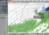
After looking at the 18z suite, I feel pretty confident on the snow on this map east of GSO. However, I’m thinking I might have to raise totals around areas like CLT and GSP.

Definitely, not Becuase I live here but Becuase that frontogenic band of snow could really lay down some quick accumulation, and there’s been signs that the snow may linger a bitAfter looking at the 18z suite, I feel pretty confident on the snow on this map east of GSO. However, I’m thinking I might have to raise totals around areas like CLT and GSP.
View attachment 35785
tucker
Member
After looking at the 18z suite, I feel pretty confident on the snow on this map east of GSO. However, I’m thinking I might have to raise totals around areas like CLT and GSP.
View attachment 35785
Interesting... The reasoning for the 1-3 for Chattanooga? dusting to a cold rain is my take.
Over the past 24hrs, the overrunning setup has boosted precip and snow over eastern TN. Though tbh, I didn’t take much thought into the TN side of the Map due to lack of geographical knowledge of the region. If this map goes against what others are saying, go with the others.Interesting... The reasoning for the 1-3 for Chattanooga? dusting to a cold rain is my take.
tucker
Member
Over the past 24hrs, the overrunning setup has boosted precip and snow over eastern TN. Though tbh, I didn’t take much thought into the TN side of the Map due to lack of geographical knowledge of the region. If this map goes against what others are saying, go with the others.
Understandable! I think we are already seeing more returns than models predicted which could bring in colder air earlier. I really was just looking for hope lol
Ilovesnow28
Member
@WeatherGirl205 thank you I will do my best to share pics and represent the Alabama wayBest wishes @Ilovesnow28, enjoy it for your fellow Alabama friends and post pictures!
After looking at the 18z suite, I feel pretty confident on the snow on this map east of GSO. However, I’m thinking I might have to raise totals around areas like CLT and GSP.
View attachment 35785
Snapshot THIS..... And compare to @Webberweather53 final map Friday. I’m digging (No Pun) this call! Thanks, Ollie.
where tf is the winter storm watch nws.
If you showed your location perhaps we’d empathize. Just saying.. ?

WHO DID THAT TO MY AVATAR
Shaggy
Member
So some of the models have it snowing over me from hr 24 to 36 so a total of 12 hours but I only get 3 inches?
MNGR NOW
Melting. Low rates at times. Delayed transition. Mixing. Warm ground. I’m sure there is sound reasoning somewhere to look at.So some of the models have it snowing over me from hr 24 to 36 so a total of 12 hours but I only get 3 inches?
- Status
- Not open for further replies.