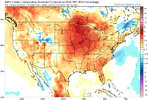
Question is who am I going to see at the bottom? Who's already jumped? @weatherfide @Stevo24 @SnowNiner @Jimmy Hypocracy @JHSFebruary 5th. That's the day I guess it's still at least a glimmer of hope of maybe a flake or two. More importantly it's also the day Feb 20th will be in view on the ensembles, and if it still looks like this I'm at least walking to the cliff and most likely jumping. There is simply still no cold air showing up. Fab Feb is quickly going down the shitter
View attachment 144128
-
Hello, please take a minute to check out our awesome content, contributed by the wonderful members of our community. We hope you'll add your own thoughts and opinions by making a free account!
You are using an out of date browser. It may not display this or other websites correctly.
You should upgrade or use an alternative browser.
You should upgrade or use an alternative browser.
Misc Winter Weather Support Group
- Thread starter RBR71
- Start date
- Joined
- Jan 5, 2017
- Messages
- 3,773
- Reaction score
- 5,983
Yep...busy working on my hurricane bunker at the base of the cliff. I hear it's gonna be rock'n this year...Question is who am I going to see at the bottom? Who's already jumped? @weatherfide @Stevo24 @SnowNiner @Jimmy Hypocracy @JHS
Iv jumped but it seems to be an endless loop where every time I jump I end up back on top of the cliff again. It’s a weird setup.Question is who am I going to see at the bottom? Who's already jumped? @weatherfide @Stevo24 @SnowNiner @Jimmy Hypocracy @JHS
- Joined
- Jan 5, 2017
- Messages
- 3,773
- Reaction score
- 5,983
It's cause you keep jumping into the thermals...you got to time it right.Iv jumped but it seems to be an endless loop where every time I jump I end up back on top of the cliff again. It’s a weird setup.
Teach Lesley
Member
It doesn’t work like it used to.Iv jumped but it seems to be an endless loop where every time I jump I end up back on top of the cliff again. It’s a weird setup.
75%…that’s very optimistic. I’m like 90% for Raleigh. We are still in the mode of week 3 things looks better and that puts us at mid Feb.Hate to say it, but I am approaching 75% confidence in no substantial Winter weather for my back yard this season.
I hate to be missing out since this was the highest chance since 2010/2014.
I am going to resend my proposal to the weather governments to stop running sensible weather models past 5 days.
It's just a drain on computer resources that can be used to figure out a more accurate global pattern first.
It's just a drain on computer resources that can be used to figure out a more accurate global pattern first.
I can almost guarantee your area sees snowfall before the season end. It might even be in March, but it's coming!75%…that’s very optimistic. I’m like 90% for Raleigh. We are still in the mode of week 3 things looks better and that puts us at mid Feb.
They should stop printing precip/snow maps day 7 and beyond.I am going to resend my proposal to the weather governments to stop running sensible weather models past 5 days.
It's just a drain on computer resources that can be used to figure out a more accurate global pattern first.
- Joined
- Jan 5, 2017
- Messages
- 3,773
- Reaction score
- 5,983
Nothing should be running past 144 hours. That would save everyone's reputation.They should stop printing precip/snow maps day 7 and beyond.
SnowNiner
Member
Question is who am I going to see at the bottom? Who's already jumped? @weatherfide @Stevo24 @SnowNiner @Jimmy Hypocracy @JHS
No, I haven't jumped yet. Holding out a sliver of hope for mid February against my better judgement. But if the ensembles look like they do now next week, yeah, it'll probably be time to acknowledge this Feb is going to be like the last 8.

Models should run past D5, next post day 16 map
Well we need hemispheric modeled data past day 5 but not surface crap that we get know.Nothing should be running past 144 hours. That would save everyone's reputation.
YesHow many runs in a row can the NE press keep trending worse?
View attachment 144137
Heelyes
Member
Stevo has a parachute, he jumps dailyQuestion is who am I going to see at the bottom? Who's already jumped? @weatherfide @Stevo24 @SnowNiner @Jimmy Hypocracy @JHS
This is the way
I’m jumping as we speakStevo has a parachute, he jumps daily
I am having fun watching which model is the first to truly cut the system. We are getting closer every run!
I mean technically, the ICON probably would have yesterday... but of course it's showing snow today so it's wrong.
I mean technically, the ICON probably would have yesterday... but of course it's showing snow today so it's wrong.
Probably the canadianI am having fun watching which model is the first to truly cut the system. We are getting closer every run!
Heelyes
Member
Wen severe thread?
It can't cut into such a strong block!!1!I am having fun watching which model is the first to truly cut the system. We are getting closer every run!
I mean technically, the ICON probably would have yesterday... but of course it's showing snow today so it's wrong.
Well, I am satisfied now. It looks like the GFS has the initial/messy low placement close to where Canadian and ICON had the idea yesterday.
I am vindicated.
Good night everyone.
I am vindicated.
Good night everyone.
- Joined
- Jan 23, 2021
- Messages
- 4,602
- Reaction score
- 15,197
- Location
- Lebanon Township, Durham County NC
we need to be sure we know what terms mean when we use them.
They're just being prophetic a couple days in advance of the inevitable.we need to be sure we know what terms mean when we use them.
I don't even know whats really going on with the low. It's like a hybrid between a miller a and b.
Someone please help me learn my ABCs so I can get all these miller people's names right!
Someone please help me learn my ABCs so I can get all these miller people's names right!
Ilovesnow28
Member
I might as well buy me a snow machine for my front and back yard since I want be seeing any real snow for the foreseeable future
Flotown
Member
this is gonna slam high elevation in nc...i think thats a given
not cold enough. Won’t workI might as well buy me a snow machine for my front and back yard since I want be seeing any real snow for the foreseeable future
NBAcentel
Member
This isn’t close to life support yet, this is like being in the hospital with a 104 fever and shittingon yourself with Ebola, and the meds are keeping you stable at the moment
rburrel2
Member
2.5 inch snow mean for Charlotte and counting.... whew.
Ilovesnow28
Member
Well that sucks even morenot cold enough. Won’t work
It'll be cold enough for you to make some in March when the eastern trough settles in thru May.Well that sucks even more
It'll be cold enough for you to make some in March when the eastern trough settles in thru May.
it will be snowing at 5,000 feet all spring.
I’m here til the wheels fall off, boys. Only problem is all 4 tires have one lug left and they’re all cross threaded
Don't let the GEFS suck ya in boys! I wish I would have saved some of those awesome skewed means I've had over the years that resulted in zilch. Hell even had a 7 inch EPS mean 4 days out back in Jan 19 or Jan 20, can't remember, but I do remember getting skunked! Sorry boys but they are worthless


