B
Brick Tamland
Guest
Looks like half the members have snow here, with a couple nice hits. I'd take that.
Lol same. This run says there is a 75% chance of seeing measurable snow here, which I am completely fine with.I’ll take e14. They look good.
Enough to keep me interested. Would like to euro to give me a nice run to really keep me into the threat. E14 and I’m good for the winter hah.
We all say we'd be happy but I bet you the next storm that rolls around we all still want more snow. It's like eating a bag of potato chips. In the northern US after seeing snowstorms for months on end it's akin to leaving the bag open for a few months, after a while they go stale, soggy, and just quite frankly get annoying. Here it happens often enough to where we get one or two and it just makes us hungrier and wish we had more. The old saying of "I betcha can't eat just one" rings true in the south when it comes to winter storms

A chance of snow has been added for the Northern Midlands from KCAE. This is going to come down to how close, and how much moisture can be lingering around as the cold air sweeps through. Yeah, there could be a bigger surprise for some, but I'd like to see a lot more members from both the GEFS and EPS showing a bigger event to feel confident about it for my SC friends.

Since yesterday, FFC added Thursday night, Friday night, and Saturday to a chance of rain/snow showers here. Their confidence in the first good chance of seeing something is increasing it seems.A chance of snow has been added for the Northern Midlands from KCAE. This is going to come down to how close, and how much moisture can be lingering around as the cold air sweeps through. Yeah, there could be a bigger surprise for some, but I'd like to see a lot more members from both the GEFS and EPS showing a bigger event to feel confident about it for my SC friends.


Which area?Even the met down here said they may have to monitor the potential for a brief wintry mix. Honestly surprised that he said it.
A chance of snow has been added for the Northern Midlands from KCAE. This is going to come down to how close, and how much moisture can be lingering around as the cold air sweeps through. Yeah, there could be a bigger surprise for some, but I'd like to see a lot more members from both the GEFS and EPS showing a bigger event to feel confident about it for my SC friends.
Since yesterday, FFC added Thursday night, Friday night, and Saturday to a chance of rain/snow showers here. Their confidence in the first good chance of seeing something is increasing it seems.
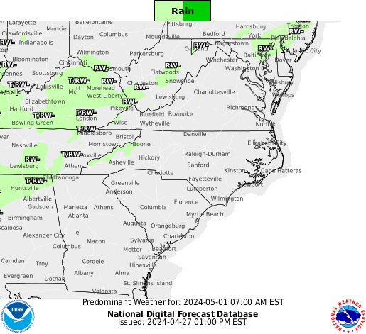
Here is what most of the offices in the SE believe.
12z GEFS 24 accumulated precip much drier and southeast at 00z Sat than many prior runs. Not sure the NW trend is going to happen this time.
After last years 1/6/17 storm, don’t put too much stock in the GEFS. Had all members giving me atleast 3 inches of snow. Ended up with a goose egg.
Even the met down here said they may have to monitor the potential for a brief wintry mix. Honestly surprised that he said it.
Lol. Theres one spot north of Camden where the None, Mix, and Rain all come together.It is a start
Do you have a UKMET map Webb? ThanksHere comes the 12z Euro... Hopefully it looks similar to the CMC/UKMET
Which area?
Thanks for the pbp, Webber! Hopefully the Euro holds. My gut feeling is it will when considering the rest of the 12z suite.No real noticeable changes just yet on the Euro out thru 24-36 hours w/ the southwestern US disturbance

Is that good or bad?Our parent disturbance looks a little bit more amped up already over Arizona by 42 hours
View attachment 1789
Is that good or bad?
Does the Euro still have a bias of holding energy in the SW too long?The entire trough base to the north of our disturbance is hanging back more over the plains and the Rockies, definitely looks closer to what the CMC was advertising
Does the Euro still have a bias of holding energy in the SW too long?

It's very possible that could be the case however given that the changes have been actually in association w/ the longwave centered further NE over the Lakes and the Plains and that the slowing of the southern piece has been evident in all suites, plus we're inside 72 hours I think it's a legit solution
Isn't the "sw bias" due to higher resolution problems? If so, the Canadian has been tweaked around 4dVAR or something along those lines and very well could be suffering from the same thing, if the idea is even true at all.