• Hello, please take a minute to check out our awesome content, contributed by the wonderful members of our community. We hope you'll add your own thoughts and opinions by making a free account!

Wintry Winter Mischief For Upper SE 3/12/18

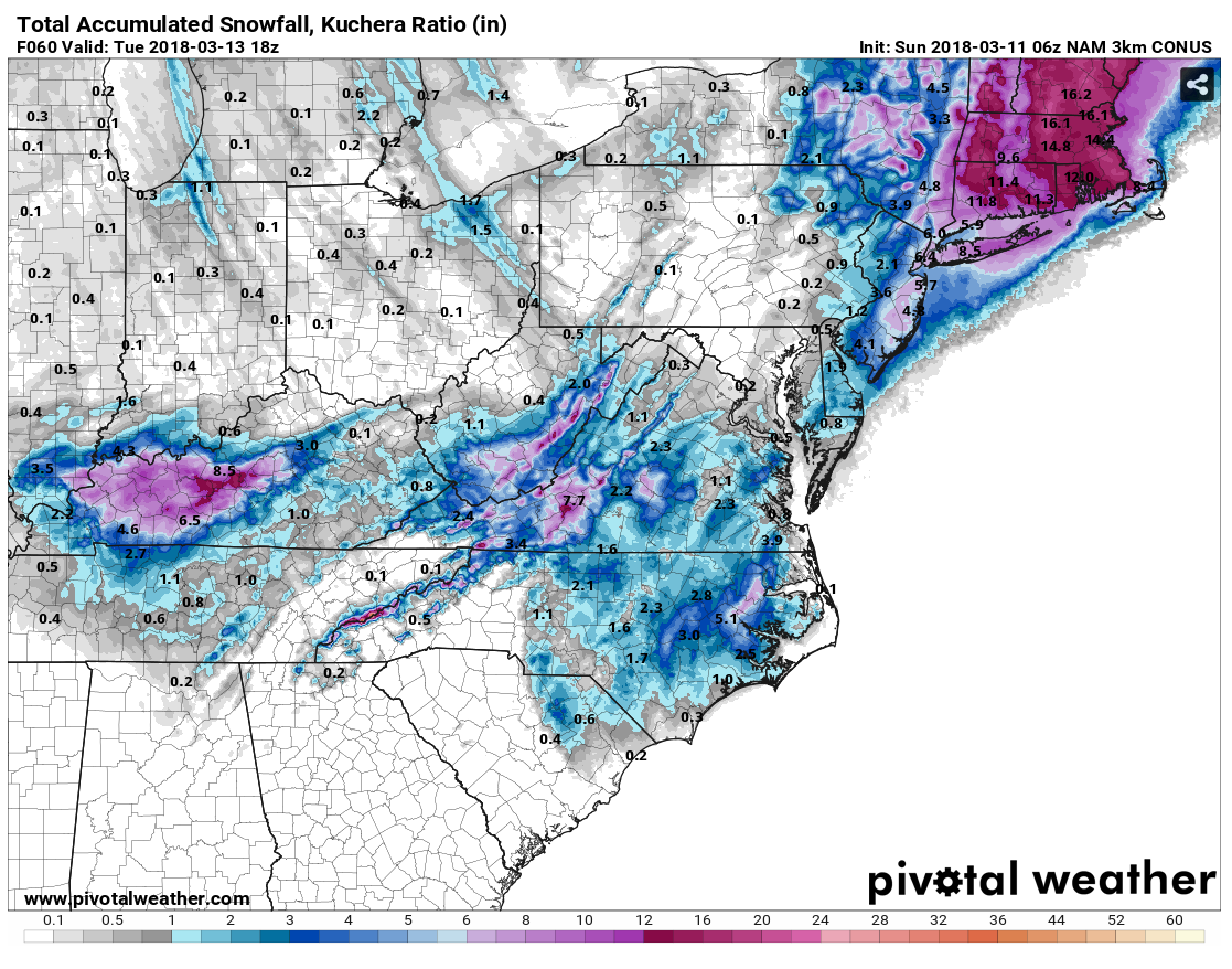
Wow these recent model runs have really got me wondering if accumulating snow is possible here tomorrow night. I bet there's going to be some surprises with this one. Of all my years living here I still haven't got that surprise snow storm. The kind where they are predicting a half inch or maybe one and you end up with 4 or more. It's gotta happen sometime so maybe this is the one. I saw the local news mentioning snow and possibly up to a half an inch in north and northeast Tennessee.
:D
Good luck!
It sure looks possible ... :p
 
Allan Huffman's call map, I would be thrilled to see this verify
0fe7de90c34af312ad2f45843a5bbad3.jpg


Sent from my SM-G920V using Tapatalk
Looks like he just included all of Raleigh just because to me. It's either the whole area or just a little bit I think. Looks too slow for any chance of even a flake here now, so I hope the MA doesn't get anything. Maybe some in NC and TN can.
 
Have heard a lot of talk about the mid atlantic but havent heard anyone mention Kentucky. Kentucky may be the big winners.
 
Look at the difference between both total precip and total snow on 18z NAM12k and 3k WTH???
Yep. I've never seen such a discrepancy. The 12k has the system flat and out to sea. The 3k goes up the coast and nails VA on up. Still a lot to iron out with this one. Personally, I think the 3k nam is the best hi res model to go with. I'm interested in seeing what the RGEM spits out too.
 
Look at the difference between both total precip and total snow on 18z NAM12k and 3k WTH???

It all really boils down to upscale growth of cyclonic potential vorticity and lowering MSLP from convection, the 3km NAM is able to resolve this however it has multiple competing low pressure centers (probably spurious). On the other hand, the 12km NAM parameterizes convection and has a singular, much stronger low just east of Hatteras but may be missing out on intense convection offshore that's important to the growth of the surface low. The diabatic contribution to this storm is certainly not as large as it was during the January 3-4 event wherein RDU was shafted w/ a mesoscale dry slot but it's still important here nonetheless.
 
A slushy inch maybe 2 NW of the triad, trace-dusting SE of there on the 12z Euro. The northern mountains are likely going to be the big winners here w/ 3-7"+ seeming probable
index.php.png
 
Gosh here's hoping some get a dream come true for March ... ;)
Good luck, my Folks on the other side of the neighborhood!
Enjoying your posts!
Think of us warmies ... :cool:
Best!
Your Curmudgeon
 
It's crazy how the NW trend just came out of nowhere after trending more suppressed a few days ago up until now. Wow hahaha
You're kidding right?! If I had a dollar for every time a system trended NW I could retire now.o_O
 
Wow, 5 inches on the NAM. Hope it is o to something. The ahort range models did a lot better with the big storm we had here in January.
 
The bulk of it is IP even out to GSO. Going to be an excellent example of why you can't depend on model snowfall maps without analyzing the boundary layer and soundings first.

nam3km_2018031018_fh46_sounding_KGSO.png


nam3km_2018031018_fh49_sounding_KGSO.png


nam3km_2018031018_fh51_sounding_KGSO.png
I do not trust most snow maps most times but especially in mid March so when I say I like our chances I should have been clearer, I like my chances of seeing something frozen fall. Earlier I posted Huffman's map which has me barely in the some snow, less than an inch zone which I stated I would be thrilled if that happened. In other words I'm not expecting a winter storm ;)
 
Well, things are changing as we get closer. Not saying it will snow 5 inches here, but we have seem before that when things slowly progress as we get closer to the zero hour is when we usually have the best storms.

Heck, even an inch of snow in March would be awesome.
 
This looks like a snow sounding to me at KRDU before the precipitation lets up, but at this rate Im grasping at straws tbh all we'd really have to deal w/ is token flakes and of course Im not sure how long it would take the warm nose to erode (usually takes longer than forecast). Meh.
nam3km_2018031018_fh54_sounding_KRDU.png
nam3km_mslp_pcpn_frzn_seus_55.png
 
Last edited:
This may not seem like a cold air damming wedge in the most classical early-mid winter sense of the definition with a strong, cold surface high over New England capping a weak surface trough towards the south but the result here is going to be largely the same to a first approximation and only lends more credence to the solutions calling for more sleet rather than snow (if there was to be significant wintry precipitation in the first place) over most of NC minus the northern mountains and foothills. Anytime you have a strong southward directed pressure gradient force (high to low) parallel to the Appalachian Mountains, you kickstart a geostrophic adjustment process that involves the coriolis force damming mass against the Atlantic side of the Apps leading to surface pressure rises and accumulation of cold air over the Carolinas and VA and vis versa on the westward side in extreme eastern TN.

namconus_mslpaNorm_eus_38.png


Yeah this is a strong CAD dome about as classic of a sounding as you'll ever see

nam3km_2018031018_fh41_sounding_KRDU.png
 
NWS 1st guess forecast thru 60 hours
indexNWS snow forecasts.php.png

12z EPS. Worth reiterating this doesn't account for lower ratios due to temps being above freezing in this event, warm ground temps, mixing w/ sleet, etc so these numbers are very generous to say the least in NC east of the mountains. We'll need to see a very intense deformation band on the back end of this storm to get anything more than a slushy inch south of the VA border in areas like RDU
index.php.png
 
9401940ae8ed7fe57747f519ad9e81eb.png

3k NAM gives us some decent backside snow as the low cranks up off the coast. Best part about this map: the big MA snowhole.
 
From my AFD;
NEAR TERM /THROUGH TONIGHT/...
"As of 500 AM EDT Sunday...

Complicated forecast with significant potential to go ary, but
decisions had to be made in order to gain necessary lead time
for potential winter storm. In essence, this upcoming winter
storm has the potential to be our biggest snowfall producer of
this entire winter so far, or it may end up being very little
and mostly rain."

The way this winter has been, I am expecting little. Good news is the fertilizer i put down a few weeks ago should finally get worked in!
 
9401940ae8ed7fe57747f519ad9e81eb.png

3k NAM gives us some decent backside snow as the low cranks up off the coast. Best part about this map: the big MA snowhole.
That is a decent hit. Maybe this will be a situation where things get better as we get closer to the storm arriving.
 
Back
Top