-
Hello, please take a minute to check out our awesome content, contributed by the wonderful members of our community. We hope you'll add your own thoughts and opinions by making a free account!
You are using an out of date browser. It may not display this or other websites correctly.
You should upgrade or use an alternative browser.
You should upgrade or use an alternative browser.
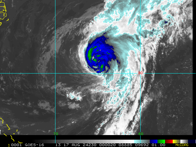
Tropical Hurricane Ernesto
- Thread starter SD
- Start date
Belle Lechat
Member
- Joined
- Aug 29, 2021
- Messages
- 715
- Reaction score
- 527

| 1 | 08/11 5:00 PM | 13.6N | 48.0W | 30MPH | 1010mb | Wnw at 21 MPH | Ptnl | Five | 08/11 4:57 PM | Hagen/cangialosi |
| 1A | 08/11 8:00 PM | 13.9N | 49.1W | 30MPH | 1009mb | Wnw at 23 MPH | Ptnl | Five | 08/11 7:45 PM | Pasch |
| 2 | 08/11 11:00 PM | 14.1N | 50.1W | 30MPH | 1009mb | Wnw at 23 MPH | Ptnl | Five | 08/11 10:45 PM | Pasch |
| 2A | 08/12 2:00 AM | 14.3N | 51.4W | 30MPH | 1009mb | Wnw at 23 MPH | Ptnl | Five | 08/12 1:36 AM | Beven |
| 3 | 08/12 5:00 AM | 14.4N | 52.5W | 30MPH | 1009mb | W at 25 MPH | Ptnl | Five | 08/12 4:54 AM | Beven |
Belle Lechat
Member
- Joined
- Aug 29, 2021
- Messages
- 715
- Reaction score
- 527


Henry2326
Member
5 am NHC.....Interpretation: they don't have confidence in the track yet.
"While the model
guidance is generally in good agreement with this scenario, there
is still uncertainty on where the predominant center will
eventually form, and this will affect where the system may track
with respect to the Leeward Islands, the Virgin Islands, and Puerto
Rico. The new forecast track has only minor adjustments from the
previous forecast."
Henry2326
Member
00z ICON (948) and HWRF (953) in agreement on a major although ICON (Sunday) a bit later than HWRF (Friday).


Belle Lechat
Member
- Joined
- Aug 29, 2021
- Messages
- 715
- Reaction score
- 527


Belle Lechat
Member
- Joined
- Aug 29, 2021
- Messages
- 715
- Reaction score
- 527

Belle Lechat
Member
- Joined
- Aug 29, 2021
- Messages
- 715
- Reaction score
- 527
| 1 | 08/11 5:00 PM | 13.6N | 48.0W | 30MPH | 1010mb | Wnw at 21 MPH | Ptnl | Five | 08/11 4:57 PM | Hagen/cangialosi |
| 1A | 08/11 8:00 PM | 13.9N | 49.1W | 30MPH | 1009mb | Wnw at 23 MPH | Ptnl | Five | 08/11 7:45 PM | Pasch |
| 2 | 08/11 11:00 PM | 14.1N | 50.1W | 30MPH | 1009mb | Wnw at 23 MPH | Ptnl | Five | 08/11 10:45 PM | Pasch |
| 2A | 08/12 2:00 AM | 14.3N | 51.4W | 30MPH | 1009mb | Wnw at 23 MPH | Ptnl | Five | 08/12 1:36 AM | Beven |
| 3 | 08/12 5:00 AM | 14.4N | 52.5W | 30MPH | 1009mb | W at 25 MPH | Ptnl | Five | 08/12 4:54 AM | Beven |
| 3A | 08/12 8:00 AM | 14.6N | 54.3W | 30MPH | 1009mb | W at 26 MPH | Ptnl | Five | 08/12 8:00 AM | Reinhart |
Belle Lechat
Member
- Joined
- Aug 29, 2021
- Messages
- 715
- Reaction score
- 527
122330 1558N 05458W 9781 00320 0138 +250 +244 089028 029 040 001 00
7:23 CDT
40 kts=46 mph Peak 10-second average surface wind speed
7:23 CDT
40 kts=46 mph Peak 10-second average surface wind speed
Drscottsmith
Member
Thanks for doing this - I like the summary table!
1 08/11 5:00 PM 13.6N 48.0W 30MPH 1010mb Wnw at 21 MPH Ptnl Five 08/11 4:57 PM Hagen/cangialosi 1A 08/11 8:00 PM 13.9N 49.1W 30MPH 1009mb Wnw at 23 MPH Ptnl Five 08/11 7:45 PM Pasch 2 08/11 11:00 PM 14.1N 50.1W 30MPH 1009mb Wnw at 23 MPH Ptnl Five 08/11 10:45 PM Pasch 2A 08/12 2:00 AM 14.3N 51.4W 30MPH 1009mb Wnw at 23 MPH Ptnl Five 08/12 1:36 AM Beven 3 08/12 5:00 AM 14.4N 52.5W 30MPH 1009mb W at 25 MPH Ptnl Five 08/12 4:54 AM Beven 3A 08/12 8:00 AM 14.6N 54.3W 30MPH 1009mb W at 26 MPH Ptnl Five 08/12 8:00 AM Reinhart
Belle Lechat
Member
- Joined
- Aug 29, 2021
- Messages
- 715
- Reaction score
- 527
Highlighting this line0Z UKMET: similar to 12Z run
NEW TROPICAL CYCLONE FORECAST TO DEVELOP AFTER 84 HOURS
FORECAST POSITION AT T+ 84 : 22.7N 71.1W
LEAD CENTRAL MAXIMUM WIND
VERIFYING TIME TIME POSITION PRESSURE (MB) SPEED (KNOTS)
-------------- ---- -------- ------------- -------------
1200UTC 15.08.2024 84 22.7N 71.1W 1006 43
0000UTC 16.08.2024 96 24.1N 71.2W 1004 47
1200UTC 16.08.2024 108 26.1N 70.1W 1000 48
0000UTC 17.08.2024 120 27.7N 69.8W 998 43
1200UTC 17.08.2024 132 28.8N 69.9W 997 50
0000UTC 18.08.2024 144 30.2N 70.1W 995 52
1200UTC 18.08.2024 156 32.8N 69.3W 993 50
0000UTC 19.08.2024 168 36.4N 68.2W 982 63
1200UTC 15.08.2024 84 22.7N 71.1W 1006 43
43 kts=49.48 mph
Let's see how long it really takes to go up 3 knots.
Belle Lechat
Member
- Joined
- Aug 29, 2021
- Messages
- 715
- Reaction score
- 527
Glad you like it.Thanks for doing this - I like the summary table!
") If anybody else wants to beat me to it, I copy and paste from the bottom of
If anybody else wants to beat me to it, I copy and paste from the bottom of Ptnl Five Spotlight (2024) - FLHurricane.com
flhurricane is a Website focused on the tracking, data, and discussion of Atlantic Hurricanes with a focus on Florida.
Belle Lechat
Member
- Joined
- Aug 29, 2021
- Messages
- 715
- Reaction score
- 527
Intermediate Advisory Number 3A
NWS National Hurricane Center Miami FL AL052024
800 AM AST Mon Aug 12 2024
DISCUSSION AND OUTLOOK
Some strengthening is forecast during the next couple of days, and
the disturbance is expected to become a tropical depression later
today or tonight and become a tropical storm as it nears the Leeward
Islands.
Belle Lechat
Member
- Joined
- Aug 29, 2021
- Messages
- 715
- Reaction score
- 527
Shaggy
Member
Still hauling butt and still no clear area of circulation for the models to latch onto
Belle Lechat
Member
- Joined
- Aug 29, 2021
- Messages
- 715
- Reaction score
- 527
Second plane is up.
Belle Lechat
Member
- Joined
- Aug 29, 2021
- Messages
- 715
- Reaction score
- 527
If I am correct, I think I can see it in the large map in #27. It looks like the center lower down lags the center above.Still hauling butt and still no clear area of circulation for the models to latch onto
I have a feeling a weaker storm and running into land/islands will result in a further west track that could hammer New England or Canada
Belle Lechat
Member
- Joined
- Aug 29, 2021
- Messages
- 715
- Reaction score
- 527

Belle Lechat
Member
- Joined
- Aug 29, 2021
- Messages
- 715
- Reaction score
- 527
