Henry2326
Member
18z runs should clear alot of things up thenNHC 2:00 pm....hurricane hunters investigated this afternoon.
But it's shifting toward more of a Euro look. Although a weaker system than past runs, it's picking it up a full 2 days sooner then the Euro. I think still much to worked out as a center gets identified in the next 2 days.out to sea on the 18z run

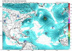
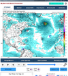
Little bit of spread in eps but yeah most likely otsGoing nowhere fast but yeah most of the models are out to seaView attachment 121208
All show hitting a wall and turning.Going nowhere fast but yeah most of the models are out to seaView attachment 121208