Brent
Member
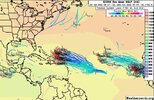
Let's go... Could be our first legit threat
KODLet's go... Could be our first legit threat
KOD?
Yikes.Kiss of death I think. I mean given how the season has been so far.... ?
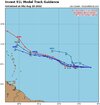
Yeah I feel this is the one. Both the Euro and the GFS are showing something and when the Euro is onboard, I think this maybe a legit threat


Dorian comes to mind with the stall near the Bahamas of course not expecting the same intensity thoughIm getting an Andrew vibe. If it can survive alot of really bad conditions it may end up in a sweet spot.
Long way to go with this one. Way too early to rule out impacts to the USA