-
Hello, please take a minute to check out our awesome content, contributed by the wonderful members of our community. We hope you'll add your own thoughts and opinions by making a free account!
You are using an out of date browser. It may not display this or other websites correctly.
You should upgrade or use an alternative browser.
You should upgrade or use an alternative browser.
Tropical Tropical Storm Beryl 2024
- Thread starter SD
- Start date
Brent
Member
Despite weakening, it’s putting up a fight.
This storm has consistently defied expectations
Now things may change with the Yucatan ahead but like Texas better be alert
Yeah this is still a beast and just raking Jamaica

Henry2326
Member
Another tweak north toward TX....
.png")
From NHC at 5 PM:
Hurricane-force winds extend outward up to 45 miles (75 km) from the
center and tropical-storm-force winds extend outward up to 185 miles
(295 km). Kingston, Jamaica, recently reported sustained winds of
48 mph (78 km/h) and a wind gust of 81 mph (130 km/h).
Hurricane-force winds extend outward up to 45 miles (75 km) from the
center and tropical-storm-force winds extend outward up to 185 miles
(295 km). Kingston, Jamaica, recently reported sustained winds of
48 mph (78 km/h) and a wind gust of 81 mph (130 km/h).
Weakening at a very substantial pace right now.
Brent
Member
Weakening at a very substantial pace right now.
Still near Cat 4 per recon. This is about the weirdest storm I've ever seen. Any other storm would have fallen apart by now
Still near Cat 4 per recon. This is about the weirdest storm I've ever seen. Any other storm would have fallen apart by now
Indeed. Here was the NHC update from 2 hours ago, down only a little from the 140 of 5PM:
BULLETIN
Hurricane Beryl Intermediate Advisory Number 21A
NWS National Hurricane Center Miami FL AL022024
800 PM EDT Wed Jul 03 2024
...EYEWALL OF EXTREMELY DANGEROUS CATEGORY 4 BERYL MOVING NEAR
SOUTHWESTERN JAMAICA...
...EXPECTED TO APPROACH THE CAYMAN ISLANDS LATER TONIGHT...
SUMMARY OF 800 PM EDT...0000 UTC...INFORMATION
----------------------------------------------
LOCATION...17.8N 78.3W
ABOUT 100 MI...160 KM W OF KINGSTON JAMAICA
ABOUT 215 MI...350 KM ESE OF GRAND CAYMAN
MAXIMUM SUSTAINED WINDS...130 MPH...215 KM/H
PRESENT MOVEMENT...WNW OR 285 DEGREES AT 20 MPH...31 KM/H
MINIMUM CENTRAL PRESSURE...960 MB...28.35 INCHES
————————
If you had told me that before the season started that on July 3rd we’d have a hurricane that weakened to 130 mph, I would have thought you were nuts!
Last edited:
Well, the Energizer Bunny is still a cat 4 at 11PM!
Hurricane Beryl Advisory Number 22
NWS National Hurricane Center Miami FL AL022024
1100 PM EDT Wed Jul 03 2024
...CATEGORY 4 HURRICANE BERYL PULLING AWAY FROM JAMAICA...
...EXPECTED TO PASS JUST SOUTH OF THE CAYMAN ISLANDS OVERNIGHT...
SUMMARY OF 1100 PM EDT...0300 UTC...INFORMATION
-----------------------------------------------
LOCATION...18.0N 79.2W
ABOUT 160 MI...255 KM SE OF GRAND CAYMAN
ABOUT 560 MI...905 KM ESE OF TULUM MEXICO
MAXIMUM SUSTAINED WINDS...130 MPH...215 KM/H
PRESENT MOVEMENT...WNW OR 290 DEGREES AT 21 MPH...33 KM/H
MINIMUM CENTRAL PRESSURE...961 MB...28.38 INCHES
Brent
Member
Storm just refuses to fall apart
The crews on board also reported that there was significant
turbulence in the northern eyewall.
The crews on board also reported that there was significant
turbulence in the northern eyewall.
Belle Lechat
Member
- Joined
- Aug 29, 2021
- Messages
- 1,547
- Reaction score
- 1,224
Storm just refuses to fall apart
The crews on board also reported that there was significant
turbulence in the northern eyewall.
Speed bumps up ahead.
lexxnchloe
Member
For the 3rd run of the last 5 and the 2nd in a row, the ICON has a major H hit on Galveston.

Belle Lechat
Member
- Joined
- Aug 29, 2021
- Messages
- 1,547
- Reaction score
- 1,224

Last edited:
Belle Lechat
Member
- Joined
- Aug 29, 2021
- Messages
- 1,547
- Reaction score
- 1,224
Recon stopped updating for 20 minutes. Normally it updates every 30 seconds.
041200 1917N 07828W 6968 03199 //// +080 //// 123054 057 039 007 01
041230 1915N 07829W 6970 03195 //// +080 //// 122054 054 042 005 01
041300 1914N 07831W 6967 03198 //// +078 //// 124053 054 042 005 01
043330 1821N 07923W 6968 03127 //// +066 //// 129071 072 050 029 01
043400 1819N 07925W 6972 03110 //// +063 //// 133079 082 058 078 01
043430 1818N 07926W 7010 03048 //// +063 //// 131084 086 070 059 05
There are a lot of blanks in the Extrapolated surface pressure column. The lowest that was shown after the above is 970.8 mb.
044530 1803N 07943W 6976 02964 9708 +213 +125 274070 073 054 000 00

The highest Peak 10-second average surface wind speed sampled since the period in which 118 kts was recorded
043830 1810N 07933W 6971 02982 //// +104 //// 172103 106 098 002 01
98 kts at 11:38 CDT, 113 mph.
Previous high at 9:45 CDT, 136 mph.
024530 1809N 07913W 6969 02915 9678 +129 //// 068076 088 118 004 01
041200 1917N 07828W 6968 03199 //// +080 //// 123054 057 039 007 01
041230 1915N 07829W 6970 03195 //// +080 //// 122054 054 042 005 01
041300 1914N 07831W 6967 03198 //// +078 //// 124053 054 042 005 01
043330 1821N 07923W 6968 03127 //// +066 //// 129071 072 050 029 01
043400 1819N 07925W 6972 03110 //// +063 //// 133079 082 058 078 01
043430 1818N 07926W 7010 03048 //// +063 //// 131084 086 070 059 05
There are a lot of blanks in the Extrapolated surface pressure column. The lowest that was shown after the above is 970.8 mb.
044530 1803N 07943W 6976 02964 9708 +213 +125 274070 073 054 000 00
The highest Peak 10-second average surface wind speed sampled since the period in which 118 kts was recorded
043830 1810N 07933W 6971 02982 //// +104 //// 172103 106 098 002 01
98 kts at 11:38 CDT, 113 mph.
Previous high at 9:45 CDT, 136 mph.
024530 1809N 07913W 6969 02915 9678 +129 //// 068076 088 118 004 01
Last edited:
Belle Lechat
Member
- Joined
- Aug 29, 2021
- Messages
- 1,547
- Reaction score
- 1,224
I know the speed has gone down and pressure has gone up, but compared to a few hours ago it looks like the core of Beryl is shaping up.
Beryl has finally fallen below cat 4 as it is now a strong cat 3. It appears that SW Jamaica may have been the hardest hit of that island based on that tweet I just posted.
Get ready Caymans, especially Grand Cayman!
Hurricane Beryl Intermediate Advisory Number 22A
NWS National Hurricane Center Miami FL AL022024
200 AM EDT Thu Jul 04 2024
...STRONG WINDS, DANGEROUS STORM SURGE AND DAMAGING WAVES EXPECTED
ACROSS THE CAYMAN ISLANDS OVERNIGHT...
SUMMARY OF 200 AM EDT...0600 UTC...INFORMATION
----------------------------------------------
LOCATION...18.3N 80.1W
ABOUT 110 MI...175 KM SE OF GRAND CAYMAN
ABOUT 500 MI...800 KM ESE OF TULUM MEXICO
MAXIMUM SUSTAINED WINDS...125 MPH...205 KM/H
PRESENT MOVEMENT...WNW OR 285 DEGREES AT 21 MPH...33 KM/H
MINIMUM CENTRAL PRESSURE...965 MB...28.50 INCHES
Belle Lechat
Member
- Joined
- Aug 29, 2021
- Messages
- 1,547
- Reaction score
- 1,224
Two planes in the air.


Belle Lechat
Member
- Joined
- Aug 29, 2021
- Messages
- 1,547
- Reaction score
- 1,224
Looks like it's no longer a Major.
Belle Lechat
Member
- Joined
- Aug 29, 2021
- Messages
- 1,547
- Reaction score
- 1,224
Still a Category 3. 120 mph, 968 mb.


Henry2326
Member
Hurricane Beryl Discussion Number 23
NWS National Hurricane Center Miami FL AL022024
500 AM EDT Thu Jul 04 2024
Satellite images indicate that Beryl continues to have a large area
of strong convection near the center, although the overall cloud
pattern has become less symmetric. This matches the radar imagery
from Grand Cayman which shows a well-defined eyewall on the
northern side but remains open on the southern side. There isn't
much reason to believe that the gradual filling seen in the last
aircraft mission has stopped, and the initial wind speed is set to
105 kt, a bit lower than what the last aircraft data supported.
The NOAA and Air Force Hurricane Hunters should be in the cyclone
within a few hours for a better intensity estimate.
Beryl appears to be moving west-northwestward or 285/17 kt.
Overall, there are no significant changes to the track forecast. A
large ridge centered over the southeastern U.S. should cause Beryl
to move westward or west-northwestward during the next couple of
days. Model guidance is tightly clustered on a course toward the
Yucatan Peninsula early Friday and emerging into the southern Gulf
of Mexico early Saturday. The western periphery of the ridge is
forecast to weaken due to a series of shortwaves moving over the
Central Plains, causing Beryl to slow down and turn northwestward
this weekend. While there isn't an atypical amount of track spread
by the time Beryl impacts the western Gulf Coast early next week,
the average error at day 4 is about 150 miles, so it is too early to
pinpoint a specific region for the worst hazards. The new NHC
forecast is close to the model consensus and the previous forecast.
Water vapor images show a upper-level trough moving west-
southwestward over the southern Gulf of Mexico, helping to impart
moderate-to-strong shear over Beryl. While the hurricane has been
an over-performer so far, this magnitude of shear should cause
notable weakening over the next day or so, but Beryl is expected to
still be a hurricane near the Yucatan tomorrow. After emerging into
the Gulf of Mexico, Beryl will likely have a couple of days to
re-strengthen over warm waters with light or moderate shear. Almost
all of the model guidance show the system near hurricane strength as
Beryl approaches the western Gulf Coast, and so does the official
forecast. The NHC intensity forecast is basically the same as the
previous one, but should be considered of low confidence due to the
inherent uncertainties of intensity forecasts in moderate shear.
Key Messages:
1. Strong winds, dangerous storm surge, damaging waves, and areas of
flooding are expected to occur in the Cayman Islands today where a
Hurricane Warning remains in effect.
2. Hurricane-force winds, dangerous storm surge, and heavy rainfall
are expected over portions of the Yucatan Peninsula and Belize
beginning tonight as Beryl approaches that area as a hurricane.
Hurricane and Tropical Storm Warnings are now in effect
for portions of that area.
3. There remains uncertainty in the track and intensity forecast of
Beryl over the western Gulf of Mexico this weekend. Interests in
eastern Mexico and southern Texas should monitor the progress of
Beryl. Regardless of the exact track, rip currents could cause
life-threatening beach conditions beginning late Friday and
continuing through the weekend across much of the Gulf coast.
FORECAST POSITIONS AND MAX WINDS
INIT 04/0900Z 18.5N 81.0W 105 KT 120 MPH
12H 04/1800Z 19.0N 83.6W 95 KT 110 MPH
24H 05/0600Z 19.5N 86.7W 80 KT 90 MPH
36H 05/1800Z 20.3N 89.2W 50 KT 60 MPH...INLAND
48H 06/0600Z 21.2N 91.5W 50 KT 60 MPH...OVER WATER
60H 06/1800Z 22.3N 93.6W 55 KT 65 MPH
72H 07/0600Z 23.3N 95.3W 60 KT 70 MPH
96H 08/0600Z 25.2N 97.6W 65 KT 75 MPH...NEAR COAST
120H 09/0600Z 27.0N 99.3W 35 KT 40 MPH...INLAND
Belle Lechat
Member
- Joined
- Aug 29, 2021
- Messages
- 1,547
- Reaction score
- 1,224
100600 1839N 08107W 6951 02932 9640 +201 +203 144029 036 075 001 01
5:06 CDT
100430 1845N 08107W 6936 02978 9754 +135 +147 108078 087 101 011 01
5:04 CDT
101 kts = 116 mph
5:06 CDT
100430 1845N 08107W 6936 02978 9754 +135 +147 108078 087 101 011 01
5:04 CDT
101 kts = 116 mph
accu35
Member
Beryl took a good north wobble, it’s north of the 6z eps suits.
accu35
Member

NHC 11AM forecast yesterday:
36H 05/0000Z 19.0N 85.5W 90 KT 105 MPH
NHC 5AM forecast today:
12H 04/1800Z 19.0N 83.6W 95 KT 110 MPH
NHC 11AM actual location:
INIT 04/1500Z 19.0N 82.6W 100 KT 115 MPH
By comparing these 3, one can see the trend that she gets as far N as 19.0N at a further E longitude: note that current location of 19.0N is with longitude of 82.6W vs 85.5W on yesterday’s 11AM forecast and 83.6W on today’s 5AM forecast. The implications are that this may mean a further N landfall in the W Gulf than earlier forecasted.
MichaelAndrews
Member
How the heck is this storm still alive let alone a cat3 after all it’s gone through???
What a beast
What a beast
accu35
Member
Yeah, and if it tips the Yucatán and stays north with less land reaction than things will be different for sureHow the heck is this storm still alive let alone a cat3 after all it’s gone through???
What a beast
Brent
Member
The weakening is not going well again
12Z Euro: slightly N of its 0Z run and near yesterday’s 12Z run; it is ~90 miles S of TX border, which is where 12Z UKMET is and is between 12Z GFS and 12Z CMC
So, from N to S for 12Z global runs:
ICON (Matagorda)
GFS (60 miles S of TX border)
Euro/UKMET (90 miles S of TX border)
CMC (125 miles S of TX border)
So, from N to S for 12Z global runs:
ICON (Matagorda)
GFS (60 miles S of TX border)
Euro/UKMET (90 miles S of TX border)
CMC (125 miles S of TX border)
Downeastnc
Member
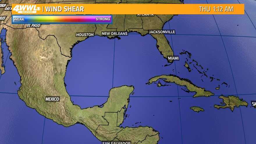
The weakening is not going well againView attachment 148325
While it has interacted with land its got a well established core that has never been really disrupted...lucky for the Yucatan there is shear otherwise yeeesh.....next recon will probably find lowering pressures
Finally just below major H status:
BULLETIN
Hurricane Beryl Intermediate Advisory Number 24A
NWS National Hurricane Center Miami FL AL022024
200 PM EDT Thu Jul 04 2024
...CENTER OF BERYL MOVING ACROSS THE NORTHWESTERN CARIBBEAN SEA...
...STRONG WINDS, DANGEROUS STORM SURGE, AND DAMAGING WAVES EXPECTED
ON THE COAST OF THE YUCATAN PENINSULA OF MEXICO BY EARLY FRIDAY...
SUMMARY OF 200 PM EDT...1800 UTC...INFORMATION
----------------------------------------------
LOCATION...19.2N 83.4W
ABOUT 135 MI...215 KM W OF GRAND CAYMAN
ABOUT 275 MI...445 KM ESE OF TULUM MEXICO
MAXIMUM SUSTAINED WINDS...110 MPH...175 KM/H
PRESENT MOVEMENT...WNW OR 285 DEGREES AT 18 MPH...30 KM/H
MINIMUM CENTRAL PRESSURE...974 MB...28.76 INCHES
Henry2326
Member
12Z HWRF.....at the TX/MX border at 958.....Looks like NHC likes that spot too since they put the "H" on it (center of their cone). LOL

accu35
Member
I just don’t understood why models have it going there with this north trend happening? Icon seems more realistic12Z HWRF.....at the TX/MX border at 958.....Looks like NHC likes that spot too since they put the "H" on it (center of their cone). LOL
View attachment 148326
Henry2326
Member
It will be more realistic when the path shows how far south it crosses the peninsula. NHC is indicating speed is a key input.I just don’t understood why models have it going there with this north trend happening? Icon seems more realistic
NHC 11:00 am discussion -
"While the guidance has come into better agreement, there is a spread in the guidance landfall points from northeastern Mexico to the middle Texas coast, and users are reminded that the average error at day 4 is about 150 miles. Thus, it is still too early to pinpoint a specific region
for the worst hazards. The new official forecast is similar to, but a touch slower than, the previous forecast and it lies close to the
consensus models."
Hurricane Beryl Advisory Number 25
NWS National Hurricane Center Miami FL AL022024
500 PM EDT Thu Jul 04 2024
...CENTER OF BERYL HEADING FOR THE YUCATAN PENINSULA OF MEXICO...
...STRONG WINDS, DANGEROUS STORM SURGE, AND DAMAGING WAVES EXPECTED
ON THE COAST OF THE YUCATAN PENINSULA BY EARLY FRIDAY...
SUMMARY OF 500 PM EDT...2100 UTC...INFORMATION
----------------------------------------------
LOCATION...19.5N 84.3W
ABOUT 215 MI...345 KM ESE OF TULUM MEXICO
ABOUT 200 MI...325 KM W OF GRAND CAYMAN
MAXIMUM SUSTAINED WINDS...110 MPH...175 KM/H
PRESENT MOVEMENT...WNW OR 285 DEGREES AT 20 MPH...31 KM/H
MINIMUM CENTRAL PRESSURE...974 MB...28.77 INCHES
DISCUSSION AND OUTLOOK
----------------------
At 500 PM EDT (2100 UTC), the center of Hurricane Beryl was located
near latitude 19.5 North, longitude 84.3 West. Beryl is moving
toward the west-northwest near 20 mph (31 km/h). A westward to west-
northwestward motion is expected during the next day or so, with
the center expected to make landfall on the Yucatan Peninsula of
Mexico early Friday. Beryl is expected to emerge over the
southwestern Gulf of Mexico Friday night and move northwestward
across the southwestern Gulf of Mexico on Saturday and Saturday
night.
Maximum sustained winds are near 110 mph (175 km/h) with higher
gusts. Slow weakening is forecast before the center makes
landfall, with additional weakening expected while Beryl crosses
the Yucatan Peninsula. Slow re-intensification is expected when
Beryl moves over the Gulf of Mexico.