That would be pretty much unheard of lol
It did happen at least twice before way back in 1973 and 1906.
And there have been several years (most notably, 1992, which we all know what happened that year) where there was only one 100*F+ day.
That would be pretty much unheard of lol
That would be pretty much unheard of lol
Only 1906 and 1973 recorded none
I'd be surprised if there's not at least a couple by August
Ur even more crazy than a bird lizard mix ??I'm going to make a bold prediction and say that DFW won't see a single 100*F+ day this year (the average is 20 days).
I hope I'm wrong.
I’m not sure I remember what happened in 1992, but I gotta believe that DFW manages to get a few 100+ degree days before the end of August. I do see what your saying though about how it just appears that certain things in the pattern are overall going to seem to prevail this summer.It did happen at least twice before way back in 1973 and 1906.
And there have been several years (most notably, 1992, which we all know what happened that year) where there was only one 100*F+ day.
I’m not sure I remember what happened in 1992, but I gotta believe that DFW manages to get a few 100+ degree days before the end of August. I do see what your saying though about how it just appears that certain things in the pattern are overall going to seem to prevail this summer.

 stateclimatologist.web.illinois.edu

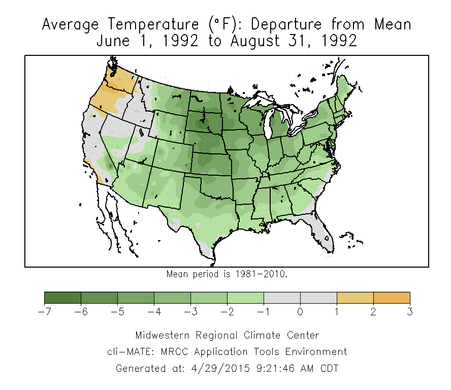
I had completely forgotten about that. The eruption was also believed to have caused the very slow hurricane season in the Atlantic that year. Unfortunately that was the year Andrew hit south Florida1992 was our modern day "year without a Summer," in part thanks to the volcanic eruption of Mount Pinatubo.
Granted, the brunt of it was in the Midwest and NE. The Pacific NW though also had one of its hottest and driest summers that year.

year without a summer | Illinois State Climatologist
stateclimatologist.web.illinois.edu

Uhh that’s almost a spring look wrt severe wx View attachment 85804View attachment 85805View attachment 85806View attachment 85807
1992 was our modern day "year without a Summer," in part thanks to the volcanic eruption of Mount Pinatubo.
Granted, the brunt of it was in the Midwest and NE. The Pacific NW though also had one of its hottest and driest summers that year.

year without a summer | Illinois State Climatologist
stateclimatologist.web.illinois.edu

Its not July.
The one thing that might put a bit of a cap on those temps is this tropical wave moving west towards the Carolinas and GA coast. Even if it doesn’t develop, I think it could definitely make the afternoon storms more widespread. The humidity is definitely going to be there thoughBeen raining a lot in eastern wake . Rain yesterday , overnight , then random downpours throughout the day today . Also the 10 day went from 82-84 to 88-90 . I told y’all as we got closer it would warm up.
Day not over yet. Still a few hours leftDidn't get a drop here today
Wow… that’s a look that you would expect to see in late March or in April.That’s some impressive wind energy for July, almost absurd for July standards outside a TC View attachment 85809View attachment 85810View attachment 85811
If/where the front stalls, probably be a weekend washout.Wow… that’s a look that you would expect to see in late March or in April.
Couple that with the tropical wave that moving towards the GA/SC coast and things could be very wet indeedIf/where the front stalls, probably be a weekend washout.
Michigan would be difficult simply because the effects the cooler water of the Great Lakes have on air temperatures. I do seem to remember Chicago getting near 105 during the 1995 heat wave. The you gotta keep in mind is the temperatures that Portland and Seattle are experiencing have never occurred there since records started.What would it take to have the same type heat (110-115) occur at the same latitude in the east, such as the UP of Michigan or Northern Maine ? Is it even possible?
If it's going to be 115 in portland we should be getting snow here right?
Brother in law rented a hotel room so they'd have ac. Like when we seek hotels with power after ice storms or hurricanes.Speaking of Portland, they officially broke their all-time high temps of 107 today. Hit 108. Tomorrow it's going to be 115. That's so insane to me. Even Seattle, which has an average high of 75 in peak Summer might equal or break Atlanta's all-time high of 106. Unbelievable. They don't even have AC there so I can't imagine what those folks in the PNW must be going through.
I’m watching if anywhere ends up hitting 120 in Canada , Ashcroft has 122 on google weather . Almost certainly too high but I hope it happens!Today and likely tomorrow are looking to be historically hot in parts of Washington, Oregon, and British Columbia as mentioned in the GW thread. Also, Tue in BC. Looking at 10AM PDT readings vs 24 hours ago:
Portland, Walla Walla, Pendleton, and Yakima are 6 F warmer.
Spokane area is 4-5 F warmer. SeaTac is 3 F warmer.
Keep in mind that June records were already obliterated yesterday in Portland and Seattle-Tac!
If nothing else big time rain event inbound, prefrontal trough on Friday front on Saturday will give us back to back days with high percentage chances.This might be a legit thread worthy severe weather threat View attachment 85827View attachment 85828View attachment 85829
