ForsythSnow
Moderator
I have never seen so much hype for a cold front before. Please don't get hyped up for this. There is nothing to see.
I have never seen so much hype for a cold front before. Please don't get hyped up for this. There is nothing to see.
I have never seen so much hype for a cold front before. Please don't get hyped up for this. There is nothing to see.
 on this. I’d get it if the FV3 or the Euro were putting out several inches of snow like the one in November, but we have nothing. Unless we get another December 2017 storm, Anafronts are dead to me. Lol.
I maybe wrong, but I believe the ICON has terrible predicted temp. profiles. The placement of moisture is ideal though, it's in the snow-zone that I drew on my map that I posted up earlier. If it was cold on that run, that would be a lot of snow on tonight's ICON run. The main front passes through, moisture builds back in as the STJ kicks in gear starting at 06z Tuesday.
I think the mountains would have the best shot at anything this early in the game. If this were a situation where snow pack was abundant to our north and a stalled arctic front that would be much different. If for any reason what you highlight works out for this area I will be the first to buy you a beer lol.I maybe wrong, but I believe the ICON has terrible predicted temp. profiles. The placement of moisture is ideal though, it's in the snow-zone that I drew on my map that I posted up earlier. If it was cold on that run, that would be a lot of snow on tonight's ICON run. The main front passes through, moisture builds back in as the STJ kicks in gear starting a 06z Tuesday.
It doesn't matter. . People are just telling him he is likely wrong. Why does that matter to you?Why does it matter if people get hyped or not? He is putting out what he thinks could happen and why. Everyone so quick to shoot it down.
It doesn't matter. . People are just telling him he is likely wrong. Why does that matter to you?


It’s still 6-7 days away. Plenty of time for models to catch on to somethingThe players are at least on the field I’ll give you that much. But if this things gonna happen models need to start showing it.
Sent from my iPhone using Tapatalk
I have never seen so much hype for a cold front before. Please don't get hyped up for this. There is nothing to see.
on this. I’d get it if the FV3 or the Euro were putting out several inches of snow like the one in November, but we have nothing. Unless we get another December 2017 storm, Anafronts are dead to me. Lol.
Sent from my iPhone using Tapatalk


I think a lot of us would cash out in E5... Good times ahead.

.png")
Aren't we in the first part of December now? I had to scrape ice off my windshield again this morning....Even the cold biased GFS is line w/ the thinking that we're actually going to be pretty mild the first portion of December. Most of the SE US will be at par for the course vs the last 8 Decembers being about 3-4F above average.
This takes us thru December 11th, hopefully that big arctic outbreak can put a dent in this.
View attachment 26950
You aren't the SEAren't we in the first part of December now? I had to scrape ice off my windshield again this morning....
Once again...... wrong threadYou aren't the SE
Sent from my SM-G975U using Tapatalk
You do recognize that those "shooting it down" are doing so with sound reasoning right? But sure why does it matter if one gets hyped, go for it, get hyped all you want just don't complain or call it a failure if/when it doesn't happen. Fact is I could point out the possibilities with any approaching storm system (if the trough would dig more, if it was just colder, if the low would slow down, if the energy would speed up, if we had divine intervention), any system and get hyped all day long, ride the hype train with caution and don't get heartbroken when those systems that aren't really systems to begin with, fail.Why does it matter if people get hyped or not? He is putting out what he thinks could happen and why. Everyone so quick to shoot it down.
But I thought we had a winter storm bearing down on us in a weekThe last couple of days have felt very fall like to me. I honestly don't care if nighttime lows are +10 AN. 40s to mid 50s for highs through Sunday. Then up for a few days, then back down. Since we're not in a winter storm pattern or staring down the barrel of a prolonged December torch, a few degrees either side of normal feels like fall and fall feels good. Who can complain about that?
But I thought we had a winter storm bearing down on us in a week


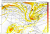
TablesetterYeah, I'm still not really seeing it. I mean, what we'd want is a low developing and moving as shown below, along with the high in the Plains moving eastward just ahead of or in tandem with it. I don't see that showing up right now. But it's fine. I'm happy to let the Midwest and Northeast get cold and snow and hopefully get a good snow pack laid down north and west of here.
View attachment 26951
The first one to post the day 10 GFS from today gets a bag of coal for CHristmas!")
We always get cold first, we need a storm to match with itStrong cold front certainly looking likely this time next week. Maybe not Winter weather, but hey, we need the cold first right?!
You do recognize that those "shooting it down" are doing so with sound reasoning right? But sure why does it matter if one gets hyped, go for it, get hyped all you want just don't complain or call it a failure if/when it doesn't happen. Fact is I could point out the possibilities with any approaching storm system (if the trough would dig more, if it was just colder, if the low would slow down, if the energy would speed up, if we had divine intervention), any system and get hyped all day long, ride the hype train with caution and don't get heartbroken when those systems that aren't really systems to begin with, fail.