Gonna need more high pressure, but the fact it’s been on 4-5 runs now, in some fashion, is encouragingNice looking Miller A storm track on the 12z GFS for the 12/21 period. It's a little warm for a massive winter storm verbatim, but the signal is there.

-
Hello, please take a minute to check out our awesome content, contributed by the wonderful members of our community. We hope you'll add your own thoughts and opinions by making a free account!
You are using an out of date browser. It may not display this or other websites correctly.
You should upgrade or use an alternative browser.
You should upgrade or use an alternative browser.
Pattern The Great December Dump
- Thread starter Rain Cold
- Start date

You can’t ask for a better low track! Need that high in Canada to be 1040ish, maybe the 50/50 low will happen and keep this South and trend colder.
SnowNiner
Member
Nice looking Miller A storm track on the 12z GFS for the 12/21 period. It's a little warm for a massive winter storm verbatim, but the signal is there.
Nice track location. That high is just too far north and not strong enough. Perhaps that trends better in time and the 50/50 gets further south. With an -NAO modeled maybe we get a SE trend this year? lol.
I could get behind the 21st but it's a timing deal as always
Sent from my SM-G975U using Tapatalk
Sent from my SM-G975U using Tapatalk
Idk bout y’all but I would still be clueless in the 6-7 day range to speculate on much. I really don’t see much at the moment in this pattern.Yeah, that storm system that some keep talking about on the GFS around the 20th/21st does have my attention as well, but it's too far out to speculate on anything for my liking. Should be able to get a better understanding of what could turn out as we head into the weekend, since by then it would be in the 6-7 day window.
Sent from my SM-A102U using Tapatalk
NoSnowATL
Member
Idk bout y’all but I would still be clueless in the 6-7 day range to speculate on much. I really don’t see much at the moment in this pattern.
I agree, one key to winter storms down here is having the cold in place before the storm arrives. I don’t see it and we haven’t seen it yet this winter. I do like the active pattern so it’s a chicken or egg kinda a thing.
Sent from my iPhone using Tapatalk
You could go a number of ways from here. A little more -nao and a little more Pacific ridge and you got something

Sent from my SM-G975U using Tapatalk

Sent from my SM-G975U using Tapatalk
You could go a number of ways from here. A little more -nao and a little more Pacific ridge and you got something
Sent from my SM-G975U using Tapatalk
The Euro is still cutting the system here as well, but it won’t take much to completely change it.
I'm not 100% sure, but the netrual ENSO may be effecting the calculations of the upper air pattern on the models. I'm not NOAA's model engineer, so I don't know, but it's a thought that came to mind that could be possible.Idk bout y’all but I would still be clueless in the 6-7 day range to speculate on much. I really don’t see much at the moment in this pattern.
Sent from my SM-A102U using Tapatalk
Gotta like that even though the euro cuts the 17/18 system that cutting enhances the west based -nao which digs another trough across the NE and into 50/50 position. Only thing that's sucks is the fact it's ugly across the us into the PacificThe Euro is still cutting the system here as well, but it won’t take much to completely change it.
Sent from my SM-G975U using Tapatalk
Gotta like that even though the euro cuts the 17/18 system that cutting enhances the west based -nao which digs another trough across the NE and into 50/50 position. Only thing that's sucks is the fact it's ugly across the us into the Pacific
Sent from my SM-G975U using Tapatalk
I think the Pacific will look better as we get closer.
Attachments
Webberweather53
Meteorologist
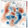
The 50-50 low has been getting much stronger on the GEFS the last several runs & digging further south. The corresponding west coast ridge is also intensifying in successive runs (increasing +PNA). Verbatim as I see it, this is a mid-Atlantic centric pattern that favors Miller B events & "fringe" snow/ice in the Carolinas, but this is definitely not a terrible pattern by any means.


Marginal cold to begin with. And we know the GFS is going to have the entire height field too far to the south nearly 10 days out 9 times out of 10.
The main way I could see this trending toward a widespread winter storm (outside of some slop in the CAD regions) is to see more robust blocking develop. Seeing that would give credence to a suppressed height field. As is, you have nearly an ideal track with a small batch of wintry precip. And that's with the bias baked in. Needs quite a bit of work.
The main way I could see this trending toward a widespread winter storm (outside of some slop in the CAD regions) is to see more robust blocking develop. Seeing that would give credence to a suppressed height field. As is, you have nearly an ideal track with a small batch of wintry precip. And that's with the bias baked in. Needs quite a bit of work.
gotta like the trend to more blocking tho on the GEFS, and that big cyclone in the pacific is trending south, which may help out a bit, and that 50/50 is trending south, also that's a nice -AO
That blocking trend is going to be critical for this time period, if we are going to see a winter storm in the 8-10 day frame.gotta like the trend to more blocking tho on the GEFS, and that big cyclone in the pacific is trending south, which may help out a bit, and that 50/50 is trending south, also that's a nice -AOView attachment 27784
i wonder what will happen if blocking remains and the MJO becomes favorable again, if it would it would be after christmas
Euro continues to strengthen blocking. The Euro now shows the first low forming off the east coast with the trough more disjointed with the second s/w hanging back. That look could work with more tweaks.
Too late to go negative this run, low forms deep in the GOM and then moves off FL and temps are beautiful. Blocking up top is amazing.
Game on. Trends suggest possibly first substantial threat board wide.
Game on. Trends suggest possibly first substantial threat board wide.
What time period you looking at?Too late to go negative this run, low forms deep in the GOM and then moves off FL and temps are beautiful. Blocking up top is amazing.
Game on. Trends suggest possibly first substantial threat board wide.